History of Porter County, 1912County history published by The Lewis Publishing Company . . . .
Source Citation:
The Lewis Publishing Company. 1912.
History of Porter County, Indiana: A
Narrative Account of its Historical Progress, its People and its Principal
Interests.
Volume I. Chicago, Illinois: The Lewis Publishing Company. 357 p.
HISTORY OF PORTER COUNTY
158
CHAPTER VIII
TOWNSHIP HISTORY - Continued
PINE TOWNSHIP - HISTORICAL SKETCH
OF IN COURT-HOUSE CORNER-STONE - SCHOOLS - RAILROADS - POPULATION - PLEASS4NT
TOWNSHIP - LOCATION AND BOUNDSRIES - EARLY SETTLERS - SCHOOLS - RAILROADS - TOWN
OF KOUTS - CRIMES AND CASUALTIES - CENSUS REPORTS - PORTAGE TOWNSHIP - PHYSICAL
FEATURES - PIONEERS - SCHOOLS - POSTOFFICES AND VILLAGES - TRANSPORTATION
FACILITIES - HIGHWAYS - POPULATION - PORTER TOWNSHIP - LOCATION AND BOUNDARIES -
FORMERLY FISH LAKE - SETTLERS - PHYSICAL CHARACTERISTICS - SCHOOLS - POSTOFFICES
AND VILLAGES - RAILROADS - HIGHWAYS - POPULATION - UNION TOWNSHIP - LOCATION AND
BOUNDARIES - PHYSICAL FEATURES - SETTLERS - EARLY ELECTIONS - PIONEER LIFE
-"HOOSIER'S NEST" - FINLEY'S POEM - SCHOOLS - HIGHWAYS - RAILROADS - TOWN OF
WHEELER - CENSUS - WASHINGTON TOWNSHIP - LOCATION AND BOUNDARIES - FIRST
SETTLERS - SCHOOLS - RAILROADS AND VILLAGES - PRATTVILLE - WESTCHESTER TOWNSHIP
- CHANGES IN BOUNDARIES - RESOURCES - PIONEERS - SCHOOLS - TOWNS AND VILLAGES -
CHESTERTON - PORTER - RAILROADS - CENSUS REPORTS, ETC.
In the preceding chapter have been presented historical accounts of the
settlement and progress of Boone, Center, Jackson, Liberty and Morgan townships.
As it is the aim to present the township histories in alphabetical order, the
first in this chapter will be:
159
PINE TOWNSHIP
The following historical sketch of
this township was written by William Lewry, at that time trustee, for deposit in
the corner-stone of the court-house, in October, 1883:
"Pine township was organized on the 13th of August, 1853, by D. S. Steves, John
Reader, David Poor and Elias Taylor. By order of this board George Porter was
duly appointed treasurer and the township was divided into two road districts.
The civil township of Pine received its name from the growth of pine trees that
cover the northern part. The surface and physical features vary. At the north
there are high sandhills, partly covered with pine, juniper, cherries, yellow
oak and grapes. The fertility increases as you journey southward and wheat,
oats, barley, corn and hay grow in abundance. The whole township was heavily
timbered at one time. The north abounded in pine, white and red oak, cherry, elm
and white wood. The south and center abounded in beech, maple, hickory, white
ash, and other varieties. Much of the timber was sold for railroad wood and
ties, and for building cars, boats, docks and sewers at Chicago. Deer, wild
turkey, and all kinds of game were abundant up to 1860; about this time the last
Indian left the township.
"This township has been backward in settlement, many coming here to work in the
woods in the winter and leaving it in the spring. A few have been industrious
and determined to build a home, and to all appearances are doing well. In the
central part of the township there is a colony of Poles, who are
determined to build homes and cultivate land that would otherwise remain wild.
They have large families and all work with a will, from the wife down to the
six-year-old child. The children are bright, but almost wholly ignorant of the
English language.
"Owing to the tardy growth of this township, its history is rather meager. The
timber and wood business has been the main dependence of the people. Sawmills
were established at an early day in various places, but after using up the
timber in the vicinity were moved away
160
or allowed to decay, till but one remains. Charcoal and cheese wagons are the
only articles of importance manufactured in the township. The cheese factory is
in the southern part and was established by Younger Frame in 1881 and is still
run by him. Samuel C. Hacket has three charcoal kilns in the southern part. One
is about one mile west of the Laporte county line; the other two are about two
miles farther to the southwest. Mr. Hacket believes he has produced more
charcoal than any other man in Indiana. He has held all the township offices, is
a prominent leader in politics, and a most respected and honored citizen.
"The blacksmith and wagon factory of William Lewry & Son is in the northern part
of the township, at Furnessville, and has a large patronage in Pine and
Westchester townships.
"The first school house erected in the township was built on the county line
between Laporte and Porter counties thirty years ago. It was an octagon
structure, built of narrow, thick boards, placed one upon another, lapping at
the corners, and making a wall about as thick as an ordinary brick wall
nowadays. Isaac Weston sawed the lumber for this house and John Frame and Elias
Dresden were prominent among those who constructed the building and organized
the school. The second school house on the north side, District No. 2, was built
in April, 1854. The building was 14 x 20 feet, and Roman Henry received $160 for
building it. The board of trustees was composed of Theodore D. Roberts, D. S.
Steves, and John Reader. This house has passed away. A new one was built by
George Shanner in 1871 - John Frame being the trustee. The school house in
District No. 3, was built on the 16th of October, 1874; Henry Hacket trustee.
All of these school houses are of wood. School houses in District No. 4, center
of township, was built in July, 1883, by William Lewry, trustee. This is a
substantial brick structure and the first of the kind in the township.
"The roads of the township are divided into two districts - John Bayless
supervisor of the north half and William Goodwin of the south half, as follows:
Commencing at the southwest corner of section 21, thence east to the northwest
corner of section 26, thence south and east to the
161
county line. Our roads have been in bad condition. Being new and cut through
timber, it has been impossible to plow or ditch them. As the timber decays we
turnpike them, giving us roads equal to the older townships."
The above sketch by Mr. Lewry gives a fairly succinct account of the development
of the township. Since it was written an additional school district has been
established. In the school year 1911-12 the teachers in the several districts
were as follows: No. 1(Smoky Row), Mildred Carver; No. 2 (Frame), Florence
Frame; No. 3 (Brick), Ada Purdy; No. 4 (Carver), Emma Goodwin; No. 5 (Bayles),
Martita Furness. Although Pine township is well supplied with railroads, there
are no towns or villages within its borders. In the northern portion the
Michigan Central, the Pere Marquette, and the Chicago, Lake Shore & South Bend
(the last named an electric road), cross the township in a north-easterly
direction, almost parallel to the shore of Lake Michigan, and the Lake Shore &
Michigan Southern crosses the southeast corner. There are about twelve miles of
macadamized road in the township.
During the last thirty years the population has been fluctuating in character.
In 1880, three years before Mr. Lewry's account was written, 138 votes were cast
at the presidential election in November. This would indicate a total population
of about 550. In 1890, according to the United States census, the population was
596. Ten years it had increased to 634. Then came a falling off, and in 1910 it
was only 564.
PLEASANT TOWNSHIP
Pleasant township, established by
the board of county commissioners on April 12, 1836, is situated in the
southeast corner of the county, and is the largest township in the county. It is
bounded on the east by Laporte county; on the south by the Kankakee river, which
separates it from Jasper county; on the west by Boone township, and on the north
by the township of Morgan. Its area is about fifty-six square miles. Crooked
creek flows southward through the center of the township and
162
Sandy Hook creek along the western border, both emptying into the Kankakee
river. The name Pleasant was conferred upon the township on account of the
natural beauty of its location. For years before the advent of the white man,
the groves and marshes along the Kankakee river formed a favorite hunting ground
for the Indians. Game of all kinds abounded there, fur-bearing animals were
plentiful, and pleasant sites for encampments or villages could easily be found
on the higher grounds along the river. Southwest of Kouts, at a point where two
Indian trails crossed the Kankakee, the early settlers found the outlines of an
ancient fortification - so old that trees two feet or more in diameter were
growing on the embankments - indicating that the spot had been a resort for the
aborigines for years, perhaps for centuries.
John Sherwood was the first white settler in the township, coming there with his
family in 1834. During the next two years William Trinkle, John Jones, Henry
Adams, William Billings, John and Joseph Bartholomew, Enoch Billings, Martin
Reed, Morris and James Witham, Lewis Comer, John Adams, Charles Allen, Luke
Asher, Hisel Coghill, Oliver Coles and several others were added to the
population. The first election for township officers - a justice of the peace
only - was held at the house of Henry Adams on April 30, 1836, when eleven votes
were polled. The judges of election were William Billings, who acted as
inspector, Enoch Billings and Morris Witham. Lewis Comer received the unanimous
vote of the electors and became the first justice of the peace. At an election
on December 24, 1836, for justice of the peace and to fill a vacancy in the
office of associate judge, only nine votes were cast. Seneca Ball received nine
votes for judge, and John Adams the same number for justice of the peace. The
first birth was that of Henry, son of William and Gillie Ann Trinkle, December
2, 1835. The first marriage was that of Alexander Wright to a Miss Jones about
1839, and the first death was that of Jeremiah, son of John Sherwood.
As most of the early settlers located in the eastern part, between the county
line and Crooked creek, it was a natural sequence that the first school should
be taught in that section. In 1838 a small log school
163
house was erected on section 13, township 33, range 5, a short distance south of
where the Panhandle railroad now enters Porter county. It was built by the
patrons of the school and had the customary clay fireplace and greased paper
windows. A pioneer teacher says that these windows possessed a great advantage
over glass ones, as they admitted the light but prevented lazy pupils from
gazing out of the window instead of studying their lessons. A larger school
house was erected upon the same section a little later. Several years later the
first frame school house in the township was built near the same site. In the
school year 1911-12 there were five district schools in Pleasant township, in
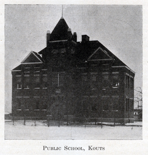
addition to the commissioned high school at Kouts. In these schools thirteen
teachers were employed, to wit: High school, E. E. Wright, superintendent;
Bertha Tofte, principal; Katherine Kring, Jeannette Anderson, Lulu M. Benkie,
Grace Jones, Frederica Witham and Hattie Felton; District No. 1 (Marshal Grove),
Claire Hannon; No. 4 (Five Points), Marie Beckwith; No. 5 (Morrison), Marguerite
Tofte; No. 7 (Lauer), Grace Gay; No. 8 (Stowell), Clara Young.
Agriculture has always been the leading industry of the people. The soil is
fertile and well adapted to hay, grain, corn and potatoes. A considerable
portion of the land lies in the Kankakee marshes and has to be drained before it
can be successfully cultivated. Several large ditches have been constructed
through the township, and where the land has been thus reclaimed it yields large
profits to the owner. The Pittsburgh, Cincinnati, Chicago & St. Louis railroad,
commonly called the Panhandle, runs east and west, two miles south of the
northern boundary; the Chicago & Erie railroad crosses the eastern boundary a
little south of the center and runs in a northwesterly direction, crossing the
Panhandle at Kouts, and a line of the Chicago b Eastern Illinois system crosses
the southeast corner. These lines afford good transportation facilities for
practically all parts of the township. Very little macadamized road has been
built in Pleasant, but in the summer of 1912 there were some sixteen miles under
construction.
Kouts is the only village of importance. It is situated about two miles
164
northwest of the center, at the junction of the Erie and Panhandle railroads as
already mentioned. This town was laid out by Bernard Kouts, from whom it took
its name, about the time the railroad was completed. A postoffice was
established there in 1865, with H. A. Wright as postmaster. Mr. Kouts built the
first business building in the town, and the second was built by Brown & Dilley.
When the Erie railroad was built
in 1881, Kouts began to grow more rapidly and
now has a population of about 500. Very few attempts have been made to establish
manufacturing enterprises, and with one exception these attempts have been made
at Kouts. Joseph Hackman erected a sawmill on the bank of the Kankakee river
some years ago, but sold it to James M. Pugh, who converted it into a portable
mill and used it in various parts of the township. H. A. Wright started a cheese
factory about 1877, but after a short time aban-
165
doned the undertaking. In 1887 Jerry Ryan started an ax-handle factory which
employed five or six men for a while, but the lack of suitable timber led him to
discontinue the business. On June 21, 1912, the Kouts creamery was opened for
business. It is of a cooperative nature, the stock being owned by sixty-seven
persons, all residents of the immediate neighborhood. Kouts also has a wholesale
and retail bakery, and a saw and feed mill operated by the Betterton Milling
Company. The Porter County Bank is located here. The oldest church in the town
is the Evangelical Lutheran, of which Rev. Hicks Hicken is pastor. A Christian
church has recently been organized. There are six general stores, a hardware and
implement store, insurance agencies representing all the leading companies,
Adams and Wells Fargo express offices, and a money order postoffice with one
rural route emanating from it. The secret orders are represented by the Odd
Fellows, the Foresters of America and the Modern Woodmen. Considerable shipping
is done from Kouts, which is the only railroad station of consequence in the
township. Clanricard is a small station on the Erie, one mile from the east line
of the county, and there is a flag station called Burke's on the Chicago &
Eastern Illinois, not far from the Kankakee river.
Pleasant township has had its share of crimes and casualties. In the fall of
1873, while James M. Pugh was plowing near his residence, he found some dry
marsh grass somewhat annoying. He asked his daughter, Sarah, to get some fire
and burn the dead grass. Scarcely had she ignited the grass when a sudden change
in the direction of the wind blew the flames toward her, setting fire to her
clothing. The accident occurred about two o'clock in the afternoon, and after
intense suffering the girl died at four o'clock the following morning. In 1873 a
man named Swett was shot and killed by Charles Chase. Two murders occurred in
the year 1879, when Charles Askam was killed by John McIntosh and John Dutton
was killed by Brainard Taft. On Thursday, March 23, 1882, David Ramsey, an old
hunter and trapper was found dead in a swamp about three miles southeast of
Kouts. The day previous he had been seen in
166
Kouts, where he was drinking heavily, and was warned by Robert Hall to be
careful, not drink any more and to go home. It is supposed that he started home
and either lost his way, or deliberately wandered into the swamp, where he died
from exposure.
Census reports for the last twenty years show a steady and healthy increase in
the number of inhabitants. In 1890 the population of the township was 984, ten
years later it was 1,209, and in 1910 it was 1,424.
PORTAGE TOWNSHIP
This township was created by the
general order of the board of county commissioners, April 12, 1836, which
divided the county into ten civil townships, but the present boundaries are
materially different from the ones originally defined by that order. It is
situated in the northwest corner of the county, and is said to have been named
after Portage county, Ohio. It is bounded on the north by Lake Michigan; on the
east by the townships of Westchester and Liberty; on the south by Union
township, and on the west by Lake county. It is four miles wide from east to
west on the northern boundary, and five miles in width on the southern. Its
greatest length from north to south is a little over eight miles and its area is
about thirty-six square miles. In the northern part are the sandhills common to
the shore of Lake Michigan in that region. South of the sandhills lies the
valley of the Little Calumet river, which contains some swamp lands, and still
farther south is a level prairie, with a rich soil, well adapted to agriculture.
This prairie is watered by Salt creek and its numerous small tributaries. Salt
creek crosses the southern boundary near the southeast corner, flows northward
until it enters Liberty township near the northwest corner of section 33,
township 35, range 6, and reenters Portage township near the northeast corner of
section 20 of the same township and range. Large quantities of sand have been
shipped from this township to Chicago, and near Crisman there is a fine-grained
clay that has been used quite extensively for
167
molding, calking boilers, etc. Some bog iron ore has been found, but the
deposits are small and have never been developed.
In the spring of 1834 Jacob Wolf, Berrett Dorr and Reuben Hurlburt brought their
families and located claims in Portage township. They were the first settlers.
Jacob Wolf had three grown sons; Mr. Dorr had two sons of age, and Mr. Hurlburt
had five sons, three of whom were then in their "teens." Later in the year
George and James Spurlock and Wilford Parrott joined the settlement. During the
next two years a number of immigrants settled in the vicinity, among whom may be
mentioned Benjamin James and his son Allen, S. P. Robbins, Walker McCool, Thomas
J. Field, Henry Herold, Griffin and William Holbert, Daniel Whitaker, Francis
Spencer, J. G. Herring, George Hume, William Frame, John Hageman, Jacob Blake,
Henry Battan, John Lyons and James Connet. An old tally sheet of the election
held in April, 1836, shows that most of the above voted at that time, and at the
election in August following twenty-nine votes were cast. Henry Battan was an
old revolutionary soldier. The life and customs of these early settlers did not
differ much from those of other pioneers. The first dwellings were log cabins,
erected without nails, with greased paper windows or no windows at all, the huge
clay fireplace and the same rude furniture. There were the same dreary trips
through the forests and across the bleak prairies to Michigan City for supplies,
the same plain food and homespun clothing.
The first birth is not known. The first marriage is believed to have been that
of Henry Herold to a Miss Dorr, and the first death was that of a man named
Ashton in 1837. In that year a man named Carley opened a tavern at Willow creek,
on the old stage line running from Chicago to Detroit. Two women, whose names
seem to have been forgotten, later opened a house of entertainment for travelers
at the same place. The first school house was built in 1840 on section 20, about
a mile and a half southeast of the present village of McCool, and not long
afterward a second school house was erected in the southwest part of the
township. Among the early teachers were N. E. Yost, M. L. Ferris, W. E. Haw-
168
thorne, Lottie Hewitt, Minnie Spencer, Rose Mitchell, Cyrus Sales, Christina
Fry, Emily Gerhart, Chancey Gaylord and a Baptist minister named Bartlett. In
the school year of 1911-12 there was a certified high school at Crisman and four
district schools. The teachers in the high school were W. A. Briggs, Minnie I.
Hyde, Glen Kinne, Mary Rice and Camilla Babcock. In the district schools the
teachers were: No. 1 (Peak), Goldie Johnson; No. 6 (Dombey), L. Clyde Bay; No. 8
(McCool), Bertha Sweet; No. 9 (Wolfe), Rudolph Mahns. The absence of numbers 2,
3, 4, 5 and 7 is owing to the consolidation of districts or the absorption of
some of them by the Crisman high school.
Portage township has three postoffices, located at Crisman, Dune Park and
McCool. The first two are money order offices. Crisman was laid out by B. G.
Crisman, after which it was named. It is located on the Michigan Central
railroad in the eastern part. The postoffice was established there in 1871 and
the first postmaster was Isaac Crisman, who was also the proprietor of the first
store in the place. After a short time he sold out to Charles Seydel, who in
turn was succeeded by Joseph Bender and Joseph White. For many years this was
the only store in the township. The town has never grown to any considerable
proportions and in 1910 had a population of about 75. McCool, named after the
pioneer family, is located in the triangle between the Baltimore & Ohio, the
Elgin, Joliet & Eastern, and the Wabash railways, and apparently, like Topsy in
Uncle Tom's Cabin, it "just growed." The railroad junction attracted a few small
business enterprises, whose proprietors built dwellings in the immediate
neighborhood, others followed, and in 1910 McCool and Crisman were about the
same size. Dune Park is a small station on the Lake Shore & Michigan Southern
railroad, about a mile and a half south of Lake Michigan. It takes its name from
the sand dunes in the vicinity. In October, 1891, Frank A. Turner, of
Valparaiso, filed in the recorder's office a plat of a town named Fairview,
located on section 34, township 37, range 7, in the extreme northwest corner of
the county. The plat is rather pretentious in character, showing some six
169
hundred lots, with streets and alleys, but there was never a house built upon
the site.
About thirty-five years ago a few Swedes settled in the northern part. They were
soon followed by others of their countrymen until a large number of them came.
These people are industrial and generally make good citizens. One of their first
acts was to establish a church, which is still in existence. Presbyterian and
Methodist churches had been founded in the township many years before.
Portage township is a network of railroads. In the northern part are the Lake
Shore & Michigan Southern, and the Chicago, Lake Shore & South Bend, the latter
an electric line. Through the central part, radiating in various directions, are
the Michigan Central, the Wabash, the Elgin, Joliet & Eastern, and the Baltimore
& Ohio, and the Pittsburgh, Fort Wayne & Chicago crosses the extreme southwest
corner. The great manufacturing enterprises of Chicago have worked their way
gradually southward and eastward around the head of Lake Michigan, building up
successively the cities of Hammond, South Chicago, East Chicago, Gary and
Hobart, and the excellent transportation facilities offered in Portage township
lead many to believe that this portion of Porter county will in the near future
become a great manufacturing district.
Probably no township in the county, unless it be Center, can show a better
system of public highways than Portage. More than thirty miles of fine
macadamized roads traverse all portions of the township, and good bridges span
the streams. Like some of the other townships of Porter county, the population
of Portage has been rather variable during the last twenty years. In 1890 it was
954. Ten years later it had increased to 1,014, but in 1910 it was but 959.
PORTER TOWNSHIP
Lying southwest of Valparaiso is
the township of Porter, which is the second largest in the county, containing
forty-five square miles. It is
170
bounded on the north by Union and Center townships; on the east by Morgan; on
the south by Boone, and on the west by Lake county. When the original division
of the county into ten townships was made by the county commissioners on April
12, 1836, the territory now included in Porter township was made a part of
Boone. In March, 1838, the northern part of Boone - that portion lying north of
the line dividing townships 33 and 34 - was erected into a township called Fish
Lake, from the little body of water known as Lake Eliza, but then called Fish
Lake. In June, 1841, in response to a petition of the inhabitants, who did not
like the name of Fish Lake, the commissioners changed the name of the township
to Porter. The first settlements in what is now Porter township were made during
the years 1834-35, when Samuel and Isaac Campbell, Newton Frame, David Hurlburt,
Isaac Edwards, and a few others located in that part of Porter county. Others
who came during the next few years were the Sheffields, William McCoy, Ezra
Reeves, Morris Carman, Dr. L. A. Cass, William A. Nichols, J. C. Hathaway,
William Frakes, Alpheus French, Henry M. Wilson, A. M. Bartel, Jonathan Hough,
William C. Shreve, Edmund Hatch, David Dinwiddie, Moses and Horatio Gates,
William Robinson, Richard Jones, Asa Cobb, and a few others who became
prominently identified with the township's industries and affairs. Alpheus
French was a Baptist minister and preached the first sermon in the township.
Owing to the fact that most of Porter township is prairie land, the early
settlers were not annoyed as much by Indians as those who settled in the
timbered parts of the county. Occasionally an Indian hunting party would pass
through the settlement, but the members of it were nearly always friendly, and
there were always a few who would maintain peace and order among their fellows.
Game was plentiful and the pioneer who was a good marksman was never in fear of
a meat famine until the encroachment of civilization drove off the deer and
other game animals, and by that time the farms were so well developed that the
settler could depend upon domestic animals for his supply. For several years
after the first settlement was made, Michigan City was the nearest
171
point where supplies could be obtained, and occasional trips were made to that
port for salt, sugar and other things that could not he grown or manufactured at
home. Matches were scarce and commanded a price much higher than at the present
time, hence the fire was never allowed to go out, a little being kept at all
times "for seed." Wolves roamed over the prairie and carried off lambs and pigs
occasionally, but aside from this the losses and hardships of the early settlers
were not great.
Children belonging to the families that settled in the western part of the
township attended a school on Eagle creek, just across the line in Lake county.
The first school in the township is believed to be the one taught by Mrs.
Humphrey at her home about 1837 or 1838. This school was patronized by the
Sheffields, the Stauntons, and a few other families. One by one school houses
were erected as the population increased until there were ten districts in the
township. Two of these - Numbers 3 and 6 - have been consolidated with other
schools, and in the school year 1911-12 there were eight district schools and a
three years' high school at Boone Grove. The teachers in the high school were J.
E. Worthington, C. Marguerite De Marchus and Lillie Dorsey. In the district
schools the teachers were as follows: No. 1 (the Cobb school), Miss Myra E.
Jones; No. 2 (Gates Corners), Grace Mains; No. 4 (Kenworthy), Maud Williams; No.
5 (Merriman), Bessie Love; No. 7 (Porter Cross-roads), Marie Benedict; No. 8
(the Beach school), Neva Doyle; No. 9 (Hurlburt), Rhoda Bates; No. 10 (the
Skinner school), Gertrude Albertson. The schools of Porter township have always
maintained a high reputation for their efficiency.
In 1844 a postoffice was established at Porter Cross-roads, and was known by
that name. It was probably the first postoffice in the township. The next year a
postoffice was established at Hickory Point, just across the line in Lake
county, and the inhabitants of the western part of the township received their
mail at that office. Jeremy Hickson, the postmaster, carried the mail from Crown
Point. He was succeeded by Henry Nichols and his father, William A. Nichols, who
between them kept the office for about six years, when it was moved across the
line into Porter
172
township and a man named Porter became postmaster. At his death a few years
later the office was discontinued. The Porter Cross-roads office continued in
existence until about the close of the Civil war. The postoffices in the
township at the present time (1912) are Boone Grove and Hurlburt. Boone Grove is
an old settlement, and the postoffice there was established a few years before
the war. About 1857 Joseph Janes opened a store at Boone Grove, with a small
stock of goods, and continued in business for several years, when he closed out
his stock. With the building of the Chicago & Erie railroad, which passes
through Boone Grove, the village began to grow, and in 1910 had a population of
about 150. There is a local telephone exchange, and in 1912 the principal
business enterprises were the general stores of Dye Brothers, F. Wittenberg, and
J. B. Woods, the last named being the postmaster. For a time Boone Grove was
known as Baltimore. Hurlburt is a comparatively new place, having been made a
postoffice after the completion of the Chicago & Erie railroad, on which it is a
station about two and a half miles northwest of Boone Grove. It was named for
one of the pioneer settlers who located in that part of the township, and in
1910 had a population of over 100. It has two general stores, kept by S. H.
Adams and W. F. French, and is a shipping point for a rich agricultural
district. The Hickory Point above mentioned was on the line between Lake and
Porter counties, and was once a trading point and social center of some
importance. Shortly after the postoffice was started there in 1844 Alfred
Nichols opened a store on the Porter county side, but some years later removed
to Crown Point. A man named Wallace then conducted a store there for several
years, and when he went out of business a Mr. Carson, who had recently come from
Ohio, engaged in the mercantile business there. The discontinuance of the
postoffice, and the competition of Boone Grove, influenced Mr. Carson to close
out his stock, and with the building of the railroad Hickory Point sunk into
insignificance. It is now little more than a memory.
About two miles northwest of Hurlburt, and a short distance north of the Erie
railroad, the old Salem church was erected at an early date.
173
Before the church was built the members of the congregation held their meetings
in the homes of the settlers. Just about a mile north of this church the Old
School Presbyterians, or Scotch Covenanters, built a church. Christian and
Methodist churches were later established at Boone Grove. A more complete
account of these pioneer religious organizations will be found in the chapter
relating to Religious History.
Owing to a lack of vital statistics, it is impossible to learn at this
late date
of the first birth, the first marriage or the first death in the township. One
of the early deaths was that of a young man named Robinson, a son of John
Robinson, his death resulting from a cut in the thigh with an axe.
Porter township has been from the first an agricultural community. No
manufacturing establishments of consequence have ever been located within its
borders. About the time the Civil war commenced a Mr. Sheffield started a
sawmill in the northern part of the township,
174
where there was some timber, but no one seems to know what became of it. The
people are progressive, and some of the best improved farms in the county are to
be found in Porter township. There are about sixteen miles of macadamized road
and a number of large ditches in the township, which is crossed by two lines of
railroad. The Chicago & Erie enters the township about two and a half miles west
of the southeast corner, runs northwest through Boone Grove and Hurlburt, and
crosses the western boundary of the county not far from Salem church. About four
miles north of this road and almost parallel to it runs the Chesapeake & Ohio
(formerly the Chicago, Cincinnati & Louisville) railroad. Beatrice, in the
extreme northwest corner of the township, is the only station on this road
within the limits of Porter. Beatrice is a small place and has grown up since
the railroad was built.
The population of the township in 1890 was 1,121; in 1900 it was 1,075, and in
1910 it had decreased to 1,000. Notwithstanding this slight decrease in
population, the township has increased in wealth, and in 1911 the property of
the township was assessed for tax purposes at $1,439,590.
UNION TOWNSHIP
This township, one of the western
tier, was created by order of the board of county commissioners on April 12,
1836. In extent it is five miles from east to west and six miles from north to
south, and contains thirty square miles. It was named Union to commemorate the
federation of states in the American Republic, and has been called the "Peaceful
Township," on account of its natural beauty. Being located chiefly in the
morainic belt of the county, the surface is rolling, and, next to Jackson
township, presents a greater diversity of physical features than any other
township in Porter county. The entire area, however, can be cultivated, and
agriculture is the principal occupation of the inhabitants. Salt creek crosses
the northeast corner, and a branch of that stream flows northward through the
eastern tier of sections, uniting with the main
175
stream about half a mile south of the northern boundary. Taylor creek rises in
Hollister's lake, in the southern part, and flows northwesterly course into Lake
county. Hollister's lake is about six or seven acres in extent and is the only
lake in the township worthy of the name. Originally there was some marsh land,
but the greater portion of this has been drained and brought under cultivation.
Twenty-mile prairie extends into the northern part. Charles S. Hyde says: "This
was so named because, as an old settler facetiously said, it was 'twenty miles
from any-where' - meaning of course, that it was twenty miles (or some multiple
of twenty) from the nearest trading post, being twenty miles from Michigan City
and Laporte, and forty miles from Chicago." In the central portion the soil is
generally sandy, though there is some loam. The hard clay found in all parts of
the township makes it unprofitable to try corn growing, but wheat, oats and rye
are raised in large quantities, and the township is well adapted to grazing. The
hills, ravines and forests combined to render this part of the county an ideal
haunt for game animals, when the first white men located there they found plenty
of deer, a few bear, the lynx, the badger, the otter and other fur-bearing
animals, and a horde of prairie and gray wolves, the latter species being by far
the most numerous. There is some question as to who was the first settler.
William B. Blachly, Benjamin McCarty, James Walton, John G. Forbes, Sylvester
Forbes, Andrew and Joseph Wilson, Joseph Willey, George W. Turner, E. W. and
Noah Fowts, Lewis Walton and a few others had settled in the township by the
spring of 1836. At the election for justice of the peace on April 30, of that
year, James Walton was inspector; George W. Turner and B. Bunnell, judges; E. W.
Fowts and Joseph Willey, clerks. Fifteen votes were cast, Joseph Willey
receiving the unanimous vote for the office of justice of the peace. The
election was held at the residence of George W. Turner. "Squire" Willey was
evidently not a highly educated individual, as may be seen by the grammar and
orthography in the following entry from his docket in December after his
election:
176
"State of Indiana,
Union Township.
Porter county,
"John Burge, James Burge and Orson Strong was brought before me, Joseph Willey,
a Justice of the Peace, for trial for killen sum hogs, on or about the first day
of December, 1836, and I proceeded on the 8th day aforesaid to hear the proofs
and allegations, and the defendants was acquitted for the above offense.
Nicholas Mount, tried for profane swearing, committed, and paid his fine.
JOSEPH WILLEY, J. P."
In the pioneer days Union township was farther from the institutions of
civilization than the settlements farther north and east. It was thirty miles to
the nearest grist mill, and it was a custom for one of the settlers to make up a
wagon load of grain among the neighbors and make the three day trip with an
ox-team, distributing the flour or corn meal among the owners of the grain upon
his return. When this supply ran out another man would take his turn in going to
the mill. The miller's toll was heavy, and some of the settlers overcame the
difficulty by burning a hollow in the top of a large stump for a mortar, and
pounding their corn therein with a hard-wood pestle. The meal produced by this
method was coarse, but it was wholesome, and frequently the only supper served
was a bowl of mush made of this meal and a generous portion of fresh milk. The
implements used by the pioneer farmers were of the most primitive character. The
first plow used in the township was of the old "bull-tongue" pattern, and
harrows were made by selecting a V-shaped fork of a tree, boring holes at
regular distances through each branch of the fork and driving into them hard
wood pegs for teeth. Wheat was cut with the cradle and bound by hand. In some
cases the sickle, or "reap-hook," was used, especially if the grain was rank and
tangled by the wind. The grain was threshed with the flail, tramped out by
driving horses or cattle over it on a piece of ground smoothed off for the
purpose, or in some instances the "ground-hog" threshing machine was used. This
would
177
loosen the grain from the chaff, but did not separate them. The farmer must
accomplish that by winnowing the grain - that is by tossing it into the air -
the wind blowing the chaff away and the grain falling upon a sheet. Occasionally
there was a farmer who was the proud possessor of a "fanning mill," in which the
wheat and chaff were poured into a hopper at the top, and by turning a crank
were shaken down through the mill, a revolving fan blowing the chaff out at the
rear end while the wheat poured out of a spout at the bottom of the machine.
Many a boy has blistered his hands while turning one of these fans, no doubt
muttering meanwhile mental maledictions upon the inventor. Now, the farmer
frequently rides as he plows, his grain is harvested with the twine binder, the
Gum of the steam thresher is heard instead of the "thud, thud" of the
old-fashioned flail, and the fanning mill has gone, never to return.
Not far from the western boundary, on the old Sauk trail, James or Thomas Snow
(authorities differ as to the name), in 1833, erected the first frame house in
the township. The lumber was hauled from Laporte, and when the building was
completed Mr. Snow put in a small stock of goods, thus becoming Union township's
first merchant. Two years later he sold out to Oliver Shepard, a Yankee, who put
up a sign bearing the legend "The Hoosier's Nest," and in a short time the place
became known far and wide. The fame of this place has been perpetuated in verse
by John Finley, and as his poem is really a part of Porter county's history, it
is here reproduced.
THE HOOSIER'S
NEST
I'm told, in
riding somewhere West,
A stranger
found a Hoosier's Nest;
In other
words, a Buckeye cabin
Just big
enough to hold Queen Mab in.
Its situation
low, but airy,
Was on the
borders of a prairie;
And fearing
he might be benighted,
He hailed the
house, and then alighted.
178
The Hoosier
met him at the door;
Their
salutations soon were o'er.
He took the
stranger's horse aside,
And to a
sturdy sapling tied;
Then, having
stripped the saddle off,
He fed him in
a sugar trough.
The stranger
stooped to enter in,
The entrance
closing with a pin;
And
manifested strong desire
To sit down
by the log-heap fire,
Where half a
dozen Hoosieroons,
With mush and
milk, tin-cups and spoons,
White heads,
bare feet, and dirty faces,
Seemed much
inclined to keep their places;
But madam,
anxious to display
Her rough but
undisputed sway,
Her offspring
to the ladder led
And cuffed
the youngsters up to bed.
Invited
shortly to partake
Of venison,
milk and Johnny-cake,
The stranger
made a hearty meal,
And glances
round the room would steal.
One side was
lined with divers garments,
The other
spread with skins of varmints;
Dried
pumpkins overhead were strung,
Where venison
hams in plenty hung.
Two rifles
hung above the door,
Three dogs
lay stretched upon the floor --
In short, the
domicile was rife
With
specimens of Hoosier life.
The host, who
centered his affections
179
On game, and
range and quarter sections,
Discoursed
his weary guest for hours
'Till Somnus'
all composing powers,
Of sublunary
cares bereft 'em,
An then I
came away and left 'em.
It is claimed by some that this poem first called attention to the use of the
word "Hoosier" to designate an inhabitant of the state of Indiana. The first
school house in Union township was a log structure, 18 by 20 feet, located near
the "Hoosier's Nest," but the date of its erection is uncertain, and the name of
the first teacher cannot be learned. In October, 1883, when the corner-stone of
the court house was laid, Isaiah B. McGinley, at that time trustee of the
township, prepared a historical sketch, in which he stated that there were 447
children of school age and ten school districts in the township. Since then a
commissioned high school has been established at Wheeler, and the number of
districts has been reduced to seven. The teachers in the Wheeler high school for
the year 1911-12 were :Thurman B. Rice, Helen Whitlock, Ruth R. Matthews, Vera
S. Bradley, Flora Cobb, Ethel O. Ruth and Irene Paddock. The teachers in the
district schools were as follows: No. 2 (the Blachly school), Frank Peregrine;
No. 4 (the Peck school), Mary Conrick; No. 5 (Graves), Martha Marquart; No. 6
(Foster), Mary Cronacan; No. 7 (Gordon), Elsie Ditlow; No. 8 (Cherry Glen), Lura
Conrick; No. 10 (Spafford), Anna Ehlers.
A Sunday school was started in Portage township, just across the line, in 1838,
Benson and Ira G. Harris, two residents of Union, being active participants in
its organization, and a majority of the attendants came from Union township.
Alpheus French, a Baptist minister, held services in a grove at Blachly's
Corners in the spring of 1836, and this was probably the first sermon preached
in the township. Rev. Jacob Colclasier, a Methodist missionary, also held
services in the township at an early date, and conducted the first quarterly
meeting in January, 1840. (See the chapter on Religious History.)
180
In the matter of public highways Union township is among the most progressive in
the county, having nearly thirty miles of fine, macadamized road. Several lines
of railroad cross the township in various directions. The Pittsburgh, Fort Wayne
& Chicago crosses the northeast corner, passing through Wheeler; the Grand Trunk
runs east and west through the central portion, and the Chesapeake & Ohio
touches the southwest corner. Wheeler is the only village of importance in the
township. It was laid out in 1858, when the railroad went through, by Thomas A.
E. Campbell, who owned the land upon which the village is situated. The first
business building was that afterward occupied by Siglar Bros. with a stock of
goods, the second was the hotel called the Wheeler House, and the third was used
as a saloon by Carroll and Harner. George Longshore was the first postmaster. At
the present time Wheeler has a population of about 200, ,three general stores, a
telephone exchange, a Methodist church, lodges of Odd Fellows and Foresters, a
feed mill, and a money order postoffice, the only postoffice in the township. On
the Grand Trunk is a small station called Sedley, which was formerly a
postoffice, but which was discontinued upon the introduction of the free rural
delivery system. Some of the maps show a place called Spriggsboro on the line
between Union and Center townships, but the name does not appear on the railroad
time-tables nor in the United States postoffice guide, and no official plat of
the town was ever recorded.
The population of Union has had its "ups and downs" almost from the organization
of the township. In 1860 it was 867; in 1870 it had increased to 1,057; ten
years later it was 1,054; in 1890 it had decreased to 985; a further decrease
followed during the next decade, the population in 1900 being only 938; then
came a substantial gain, and in 1910 it was 1,069, the highest in its history.
WASHINGTON TOWNSHIP
Washington township, in the middle
of the eastern tier, was created by the board of county commissioners on April
12, 1836. Several changes
181
have been made in the western boundary, but the township of the present day has
the original boundary lines as established when it was first erected. It is
bounded on the north by Jackson township; on the east by Laporte county; on the
south by the township of Morgan, and on the west by Center. Its area is thirty
square miles, being five miles in extent from east to west and six miles from
north to south. The surface of the township is affected by the great glacial
moraine which passes through the central portion of the county, and is generally
undulating in character. Crooked creek, which is the outlet of Flint lake,
enters near the northwest corner and flows southeast to section 23, township 35,
range 5, where it turns almost due south, crossing the southern border about two
miles west of the Laporte county line. This stream has two small tributaries in
the northeastern part, so that the township is well watered and well adapted to
grazing and stock raising. The soil is similar to that of the surrounding
townships, being composed principally of clay and loam sandy in places, and
marshy in a few localities. Some of the best farms in the county are upon the
Morgan prairie, where the first settlements in the county were made.
William Morgan is credited with being the first settler. He came from Wayne
county, Ohio in the spring of 1833, and located upon the northern part of the
prairie that still bears his family name. Before the close of the year, Adam S.
Campbell, Isaac Morgan, Rufus Van Pool and Reason Bell also settled upon the
prairie. Samuel Flint took up a claim where the village of Prattville was later
located, and Jacob Coleman settled about two miles south of Flint's place. In
1834 James Blair, Isaac Werninger, James Baum and a few others, among whom was
Ruel Starr, who afterward became prominently identified with the county's
political affairs. Other settlers were David S. Holland, Benjamin Saylor, Levi
Chamberton, Seth Winslow, W. B. Smith, Michael and Andrew Ault, George B. Cline,
Joseph Todd, Henry Rinker, Anthony Boggs, Robert Fleming, John Shinabarger,
Peter Cline, Joseph Brewer and Clark Babcock. All these men and a few others
voted at the first township election on April 30, 1836, when Henry Rinker was
elected justice
182
of the peace, receiving twenty-three votes. W. B. Smith received twenty votes
and Peter Cline, seventeen, making a total of sixty votes cast.
There were still a few Indians in Washington township when the first settlers
came. Near the place where Prattville was afterward laid out there was a
Pottawatomie village of 100 or more inhabitants, with a burying-ground near it.
While these Indians were of some annoyance to the whites, they did not commit
any serious depredations, and in 1836 they removed to another location near the
Kankakee river, in the southern part of the county, where they remained until
1842, when they were removed west of the Mississippi.
The first white child born in the township was Reason Bell, Jr., a son of Reason
and Sarah Bell, who had come from Wayne county, Ohio, in 1833. The date of birth
of their son, who was also the first white child born in Porter county, was
January 11, 1834. No record can be found to show the first death or the first
marriage. The first "big" house-raising was in 1834, when some thirty settlers
gathered to assist Isaac Morgan in raising a double log house on section 16, a
little north of the Laporte road. The first tavern was opened in this year by
David Oaks not far from Prattville. A year or so later John Shinabarger started
the second tavern about a mile north of Oak's place. The first store was opened
in the double log house of Isaac Morgan above referred to, late in 1834 or early
in 1835. In May, 1836, Andrew Ault opened a general store about three-fourths of
a mile west of Prattville. He also took out license to retail liquor, his
license costing him ten dollars per annum. The first shoe shop was established
in 1835 by Adam S. Campbell, who brought his leather and other materials from
the state of New York. The same year Russell opened the first blacksmith shop
near Prattville. The fist school was taught by Mary Hammond in the winter of
1835-36. The first school house was built the following year, and not long
afterward the Luther school house was erected. Among the early teachers were
Thomas Campbell, George Partial, Nancy Trim, Dr. Pagin and Lowry Hall. In
1911-12 Washington had a township high school and five district schools, in
which the teachers were as follows:
183
High school, Elmore Perry and Mary Trudelle; District No. 3 (the Luther school),
Bess Finney; No. 4 (Prattville), Gracia Green; No. 5 (Bryarly), Mariola Cornell;
No. 6 (Island), Lillian Burns; No. 7 (Blake), Maude Green.
No stirring events have ever occurred in Washington township, hence its history
differs very little from that of any agricultural community. The men who
redeemed the soil from its wild state and brought it under cultivation cared
little for the more exciting phases of life, and were content to pursue "the
even tenor of their way." Their life was one of toil, sometimes privation, but
it had its recompense. They saw the Indian and the wild beast disappear before
the march of civilization; many of them lived to see the railroads come and
place Porter county in communication with other portions of the country; their
social intercourse was usually without envy or jealousy and their friendships
were sincere, and they have handed down to their posterity an inheritance in
which their children and their children's children may feel a just pride. As in
other portions of the county, the early settlers were compelled to go to
Michigan City for their supplies or to market their surplus products. The
nearest grist mill was at Kingsbury, a little village about six miles southeast
of Laporte, and for several years grain had to be taken there to be ground. In a
few instances the pioneer farmers went nearly a hundred miles to obtain good
seed for planting, yet with all these difficulties to contend with the
courageous frontiersman persevered, and to him Porter county owes a debt that
can never be repaid.
Washington township is crossed by four miles of railroad, all running in an
easterly and westerly direction. Near the center of the township is the Grand
Trunk, but there is no station on this line in Washington. The Baltimore & Ohio
crosses the northeast corner. Coburg, near the northern boundary is a station on
this line and a trading center for the northern part of Washington and the
southern part of Jackson townships. The Pittsburgh, Fort Wayne & Chicago enters
at the southeast corner and runs a little north of west through Valparaiso, and
the New York,
HISTORY OF PORTER COUNTY
Chicago & St. Louis (Nickel Plate) crosses the southwest corner. The time-tables
of the last named road show a small station called Nickel two miles east of
Valparaiso and near the boundary line between the townships of Washington and
Morgan. There are about fifteen miles of macadamized road in Washington, and as
the distance to Valparaiso is not more than eight miles from any portion of the
township, the people depend chiefly upon that city for their supplies. There is
no postoffice in the township, but mail is distributed daily through the medium
of the rural free delivery routes that traverse all parts of the county. The
population in 1890 was 670; in 1900 it had fallen to 556, but during the next
decade there was a substantial gain, the population in 1910 being 610.
The old town of Prattville, mentioned several times in the above sketch of
Washington township, was laid out by Thomas Pratt, Wilson Malone and Lyman
Beach. It occupied the east half of the northwest quarter of section 21,
township 35, range 5, on the Laporte road, about two miles east of the city of
Valparaiso. The plat was recorded on November 11, 1856, and a few lots were
sold, but the town never became a substantial reality and the name is about all
that remains.
Wilson Malone, son of Lester Malone, was born in Ross county, Ohio, June 18,
1805, and in that county came to manhood. The death of his parents in his youth
left him to his own resources, and in 1826, when he was twenty-one years old, he
came west, stopping in Fountain and Montgomery counties, Indiana. . On February
22, 1832, he married Sarah Swank, born in Springfield, Ohio, October 15, 1811,
the daughter of Jacob Swank, an early settler in Montgomery county. In the same
year of his marriage he removed to La Porte county and later came to Porter
county, where he continued to reside until his death, December 22, 1876. His
first earnings were invested in Porter county land; he was one of the prosperous
men of his day and was the owner of more than 1,000 acres of land at the time of
his death.
185
WESTCHESTER TOWNSHIP
When the board of county
commissioners issued the order of April 12, 1836, dividing the county into ten
civil townships, the territory now comprising Westchester was included in the
townships of Lake, Liberty and Waverly. Two months later the citizens of Lake
and Waverly townships petitioned the board of county commissioners for the
consolidation of the two townships. The petition was granted and the new
township thus formed was called Westchester. As thus created, it included all
that portion of the county lying north of the line dividing township 36 and 37.
Subsequent changes were made by the erection of Pine township, and changes in
the boundaries of Liberty and Portage, until Westchester was reduced to its
present size. It is bounded on the north by Lake Michigan; on the east by Pine
and Jackson townships; on the south by the townships of Jackson, Liberty and
Portage, and on the west by Portage. Its area is about thirty-three square
miles. In the northern part are the sandhills so common along the shore of Lake
Michigan, but the central and southern portions have a more fertile soil and are
well adapted to agriculture. Originally the surface was covered with a heavy
forest growth, but the portable sawmills have used up practically all the native
timber suitable for lumber. A great deal of sand has been shipped to Chicago,
and in the vicinity of Chesterton are fine beds of clay which has been utilized
extensively in the manufacture of brick both common and pressed. These claybeds
and the sandhills are the only mineral deposits of commercial importance in the
township.
It was in Westchester township that the first white settler in Porter county
built his cabin. In 1822 Joseph Bailly located on the Calumet river, at the
place later known as Bailly Town. A more complete account of Mr. Bailly and his
frontier post will be found in Chapter III. In 1833 Jesse Morgan came with his
family and settled in what is now Westchester. His daughter Hannah, born in
February, 1834, was the first white child born in the township. In 1835 William
Thomas, Sr., William Gosset, Jacob Beck, John Hageman, John Foster, William
Frame and
186
Pressley Warnick brought their families and located in Westchester. Some of
these men settled in territory afterward added to other townships and their
names appear as pioneers therein. Other early settlers were Eli Hendricks,
Elhanan Ranks, William Coleman, Alfred Marvin, two men named Abbott and McCoy,
and a mulatto named Landy Gavin, who had purchased his freedom from slavery. The
first death in the township was a son of Joseph Bailly in 1827, and the first
marriage was that of Esther Bailly to Col. John H. Wistler, who came from
Detroit in 1803 and erected old Fort Dearborn near the mouth of the Chicago
river. Their marriage occurred in Chicago, but they later became residents of
the township. The second marriage was between Samuel Thomas and Lucille Hale.
In the winter of 1833-34 a private school was taught at the home of Jesse
Morgan, but the name of the teacher cannot be ascertained. Two years later a
school was taught in a vacant trading post on section 5, township 36, range 5,
about a mile and a half east of the present town of Chesterton. As the
population increased regular school districts were organized, school houses
erected and teachers employed under the public school system. In the year
1911-12 there were twenty-three teachers employed in the public schools of the
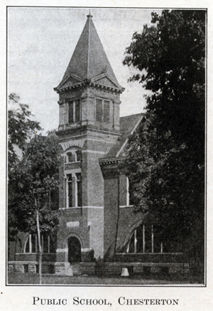
township and the incorporated towns of Chesterton and Porter. Eleven of these
teachers were in the commissioned high school at Chesterton, viz: F. M.
Goldsborough, superintendent, Galeman Dexter, principal, Matilda Swanson, Agnes
Long, Helen Miller, Etta Osborn, Jennie Crane, Dott Osborn, Agnes Morgan, Rose
Murphy and Mabel Pelham. E. E. Stultz was principal of the grammar school at
Porter, and his assistants were Emily Peterson, Tennia Osborn, Mary Bradt and
Anna Kossakowski. Of the ten school districts at one time, three have been
discontinued through consolidation, etc. The teachers in the district schools
for the year 1911-12 were as follows: No. 3 (Furnessville), Edith Lindstrom; No.
4 (Waverly), Edna Doyle; there are two schools in District No. 5, that at Bailly
Town taught by Emma Peterson, and the one at City West by Bertha Carlson; No. 6
(Old Porter), F. M. Wimple; No. 7 (Salt Creek), Mabel Brum-
187
mitt; No. 10 (Mosquito Town), oral Haslett. The school houses in all these
districts are modern in their design, well equipped with working apparatus,
etc., showing that the people of Westchester are not behind in their ideas
pertaining to the education of their children.
The first attempt to establish a town was in the spring of 1835, when
John
Foster, who was a surveyor, laid out the town of Waverly on land belonging to
William Gosset about two miles northwest of the present town of Chesterton.
Several thousand dollars were expended in making improvements, but in 1838 a
forest fire destroyed the work that had been done and the town was abandoned.
City West was started about a year after Waverly. It was located near the mouth
of Fort creek and for a time promised to become a town of considerable
proportions, but a change
188
in the main route of travel inflicted such an injury upon the town that it sank
into decay. Porter (afterward called Old Porter) was started when the Michigan
Central railroad was built in the early '50s. The first house there was erected
by John Richards and used for a store. The second and third were built by
Frederick Michael and used for a store and dwelling, respectively. A postoffice
was established at Porter soon after it came into existence and continued there
until 1872, when it was removed to Hageman, which was started in that year by
Henry Hageman. A new postoffice was established at Porter the following year.
The two offices being only a mile apart there was considerable confusion in the
distribution of mail, and the office at Hageman was officially discontinued. The
present town of Porter was incorporated early in the year 1908, with a
population of about 500. Furnessville, in the northeastern part, takes its name
from Edwin L. Furness, who was appointed postmaster when the postoffice was
established there in 1861. This place was formerly known as Murray's Side Track.
No regular plat of this place was ever recorded. A Mr. Morgan built the first
house there in 1853. Two years later Mr. Furness built a frame house and opened
a store.
Chesterton, the largest town in the township and second largest in the county,
was at first known as Coffee Creek, from the stream of that name. It is said
that the creek is so called because a teamster lost a bag of coffee in it while
trying to cross at a time of high water. A postoffice was established there as
early as 1833 and was kept by Jesse Morgan for nearly twenty years. It was first
located on section 6, southeast of the present town, and was called Coffee Creek
postoffice. After several years the people grew tired of the name Coffee Creek
and changed it to Calumet, after the river which flows just north of the town.
When the Lake Shore & Michigan Southern railroad was completed in 1852, the town
moved northward to the railroad and by the close of that year there were some
twenty or more houses in Calumet. The next year the postoffice was removed from
Coffee Creek and the name changed to correspond to that of the town. In the
meantime a postoffice had been established at New City West, about a mile south
of the old City West, and this
189
office was consolidated with the one at Calumet, with D. H. Hopkins as
postmaster. The first house in the present town of Chesterton was erected by
Luther French in 1852 and was used for a hotel under the name of the Sieger
House. The second was built by a man named Enoch. The first brick building was
erected by Young & Wolf in 1874. Just when the name was changed to Chesterton is
a matter of some difference of opinion. The adjutant-general's report of
enlistments for service in the Civil war shows a Porter county company, most of
the members of which came from Calumet, and it is probable that the name
Chesterton was not adopted until during or after the war. It is said that the
name was changed to avoid confusion with the town of the same name in the State
of Illinois. The present name was derived from that of the township. The
Northern Indiana House was built by Leroy Brown about 1855, and kept as a hotel
by him for several years. In the early '50s Mr. Hopkins removed the Central
Hotel from City West to Calumet, where it was remodeled and used as a house of
entertainment for many years. In the early days Calumet (or Chesterton) was
known as a "tough" town, having at one time nineteen saloons, though the
population numbered only about 300. That has all been changed, and the
Chesterton of the present is as orderly a town as there is in northern Indiana.
On March 31, 1899, a petition was filed with the board of county commissioners
asking for the incorporation of Chesterton. A census taken according to law,
showing 198 voters and a total population of 716. At a special meeting of the
commissioners on April 24th, an election was ordered for May 4, 1899, when the
people should vote on the question of incorporation. The proposition was carried
by a vote of three to one, and since then Chesterton has been an incorporated
town. Chesterton has a bank with a capital of $25, 000, an ice company, a
telephone exchange, a number of well appointed retail stores covering all lines
of merchandise, Catholic, Methodist, Lutheran and Swedish Methodist and Lutheran
churches, and lodges of a number of the leading secret and benevolent
organizations. The population was 1,400, an
190
increase of 612 during the preceding ten years. (See Chapters XII and XIII for
detailed accounts of fraternal organizations and churches.)
Some difficulty was encountered in the incorporation of the town of Porter. A
petition was first filed with the county commissioners on August 7, 1907, but
when it came for hearing on September 2nd, a number of citizens appeared and
asked for the exclusion of certain territory. The board dismissed the petition,
chiefly on the grounds that the petition had filed no bond. On October 7th a new
petition, accompanied by a satisfactory bond, was filed with the board, but
again the remonstrators appeared and succeeded in defeating the project to
incorporate. The petitioners then appealed to the circuit court, which tribunal
ordered an amended plat, excluding the territory in question, and the matter was
then referred back to the commissioners, who ordered an election to be held on
the last day of February, 1908, when the people might vote on the question of
incorporation. At that election eighty-three votes were cast in favor of the
proposition, and only eighteen in the negative. Porter has one Congregational
and three Lutheran churches, a commercial club, a large department store and
several other mercantile establishments, and in 1910 reported a population of
524.
Westchester township is well supplied with railroads. The Michigan Central, the
Lake Shore & Michigan Southern, the Elgin, Joliet & Eastern, and the Pere
Marquette all center at Chesterton and Porter, the Chicago, Lake Shore & South
Bend electric line passes through the northern part, and another electric line
connects Chesterton with Valparaiso. West of Chesterton there is a place marked
"Gilbertville" on some of the maps, but no official plat of the town was ever
filed in the office of the county recorder. There are about thirty miles of
macadamized road in the township.
In 1890 the population of the township was 2,669. During the next ten years it
decreased to 2,455, but since 1900 there has been a marked increase, and in 1910
it was 2,953, a gain of almost 500 during the decade.
NAVIGATION OF
1912 HISTORY OF PORTER COUNTY
PREFACE
CONTENTS
CHAPTER I - General Features
CHAPTER II - Aboriginal Inhabitants
CHAPTER III - Settlement and Organization
CHAPTER IV - Internal Improvements
CHAPTER V - Educational Developments
CHAPTER VI - Military History
CHAPTER VII - Township History
CHAPTER VIII - Township History (continued)
CHAPTER IX - The City of Valparaiso
CHAPTER X - Financial and Industrial
CHAPTER XI - The Professions
CHAPTER XII - Societies and Fraternities
CHAPTER XIII - Religious History
CHAPTER XIV - Miscellaneous History
CHAPTER XV - Statistical Review
Transcribed by Steven R. Shook, November 2011