History of Porter County, 1912County history published by The Lewis Publishing Company . . . .
Source Citation:
The Lewis Publishing Company. 1912.
History of Porter County, Indiana: A
Narrative Account of its Historical Progress, its People and its Principal
Interests.
Volume I. Chicago, Illinois: The Lewis Publishing Company. 357 p.
HISTORY OF PORTER COUNTY
50
CHAPTER IV
INTERNAL IMPROVEMENTS
COUNTY REVENUES - TREASURER'S
FIRST REPORT - LAKE COUNTY CUT OFF - NEED OF HIGHWAYS - -OLD TRAILS USED FOR
ROADS - TRADE WITH MICHIGAN CITY - FIRST ROADS ORDERED BY COUNTY COMMISSIONERS -
STATE ROADS - THREE PER CENT FUND - MICHIGAN CITY PLANK ROAD - ITS BANK -
VALPARAIS0 & LAPORTE PLANK ROAD - ACT OF 1877 - MACADAMIZED ROADS - FIRST
SESSION OF THE CIRCUIT COURT - NO COURT HOUSE - SUBSCRIPTION TO BUILD ONE -
SECOND COURT HOUSE - THE PRESENT BUILDING - JAIL - POOR FARM - THE COUNTY ASYLUM
- DITCHES - DIFFERENT SYSTEMS DESCRIBED - RAILROADS - TRUNK LINES - RESOLUTIONS
OF 1857 - ELECTRIC LINES - VALUE OF RAILROAD PROPERTY IN THE COUNTY.
As stated at the close of the preceding chapter, the organization of Porter
county was completed with the selection of a location for the county seat in
June, 1836. But the mere act of the state legislature, the report of a special
committee to locate a county seat, or the acts of a board of county
commissioners are small factors in the actual establishment of a county upon a
firm and permanent foundation. What the county needs first is an intelligent,
industrious, law-abiding population, numerically strong enough to produce a
revenue sufficient to make the necessary improvements and place the public
institutions upon a secure footing. In the beginning the population of Porter
county was sparse, only 260 votes being cast at the election in August, 1836.
And most of
51
these few citizens were in limited financial circumstances, unable to bear the
burden of heavy taxation.
In November, 1836, the county treasurer, William Walker, made a report for the
first three months of his incumbency, showing his receipts to have been during
that period $26.36 1/4, of which there was then a balance on hand of $6.48 3/4.
This report was not very encouraging, but the men who settled Porter county were
men of courage and energy - men who were not easily dismayed - and despite the
financial conditions they moved steadily forward in their efforts to build up a
community in this then frontier region that should be a source of pride to their
posterity. How well they succeeded the present conditions in the county bear
testimony. When the county was organized in 1836, all the territory between the
western boundary and the Illinois state line was attached to Porter, and the
people in this region were placed upon the tax rolls. This territory was erected
into a separate county by the act of the legislature, approved January 18, 1837,
the principal provision of which was as follows:
"Sec. 1. Be it enacted by the General Assembly of the State of Indiana,
That all that tract of country defined, bounded and designated the county of
Lake, agreeably to an act to organize Porter county, and for other purposes,
approved January 28, 1836, from and after the fifteenth day of February, 1837,
shall be entitled to all the privileges, powers and jurisdictions which belong
to other separate and independent counties of the state of Indiana; and that
John Sailor, of Porter county, John B. Niles, of Laporte county, Israel Rush, of
St. Joseph county, John Newell, of Elkhart county, and William Allen, of Laporte
county, be, and they are hereby, appointed commissioners to locate and establish
a seat of justice in said county, who shall meet for that purpose as hereinafter
pro- vided."
By this act Porter county lost the taxes from the territory now included in Lake
county, but at the same time was relieved from the expense of making
improvements therein, so that the gain was equal to, if not greater than the
loss. For some time the principal sources of rev-
52
enue were the $1,200 represented by the county seat bonds, and the proceeds
arising from the sale of the alternate lots donated by the proprietors of the
county seat. These lots were sold by an agent of the county, and in a majority
of cases were sold on time, interest bearing notes being taken in payment, hence
the proceeds were not always immediately available. Notwithstanding this
precarious condition of the county funds certain improvements were almost
absolutely necessary. One of the greatest of these needs was the opening and
construction of highways. At the time the organic act was passed the only
authorized road in the county was the government road from Detroit to Fort
Dearborn. This road, which was opened in 1831, has been described as a "wild,
rude pathway, fatiguing in its roughness, abounding in dangers, and often
uncertain in its course." Yet over this line the government opened a mail line,
the mail being carried in knapsacks on the backs of soldiers, and established a
stage line through contractors. The road ran through what are now Jackson,
Westchester and Portage townships, and therefore was of no practical benefit to
the inhabitants in the central and southern parts of the county. Aside from this
road the pioneers depended chiefly upon the old Indian trails for their
thoroughfares.
Before the establishment of highways the people depended to a large extent upon
the water-courses and the Great Lakes as avenues of travel and commerce.
Michigan City was the nearest lake port of importance to Porter county, and it
was to that port that the settlers went for their supplies or to market their
surplus produce. The roads leading to this port were inferior, and at some
seasons were almost impassable. The streams were crossed upon pole or log
bridges of the most primitive character. The longest of these bridges was over
the Calumet river. It was sixty-four feet in length and was divided into three
spans, two cribs having been built in the stream to support the ends of
"stringers."
To remedy this state of affairs and afford better facilities for travel, the
county commissioners at the June term in 1836, took the preliminary steps for
the establishment of a number of highways. The first petition presented to the
board at this session was for a county road "to extend
53
from Portersville by the best and nearest route to the new crossway between
Andrew Taylor's and James Blair's, thence to the county line, intersecting a
road leading via Cathcart's Grove to Laporte." In response to the petition the
board appointed Wilson Malone, Morris Witham and James W. Turner viewers. At the
same time Peter Ritter, Samuel Olinger and William Thomas were appointed to view
a proposed road from the northeast corner of section 24, township 36 north,
range 5 west, to the west line of the county via Casteel's mill on Coffee creek
and Gosset's mill on Salt creek. In July the board appointed Joseph Willey,
Samuel G. Jackson and Jesse Johnston to view a country road from the north line
of the southwest quarter of section 30, township 35, range 5, to Sherwood's
ferry on the Kankakee river. Several new roads were projected at the September
term of the commissioners court, though not all of them were built. Isaac
Morgan, Reason Bell and Andrew Taylor were appointed viewers for a road from
Portersville (Valparaiso) to the county line near the mouth of Taylor's run.
This became known as the Joliet road. Another road ran from the northeast corner
of section 22, township 33, range 7, to Portersville - Henry Rinker, Isaac
Morgan and John Shinabarger, viewers. Other roads ordered at this session were
those running from Portersville to Thomas Snow's store; from Portersville to
Elijah Casteel's mill; from Portersville to Athens, near Gosset's mill; from the
new bridge on the Calumet river at the mouth of Salt creek to Deep river, and
from Portersville to the county line in the direction of Michigan City. The last
named was intended to form a link in a road from Michigan City west to the state
line. Section 9 of an act relating to state roads, approved on February 6, 1837,
provided:
"That Daniel M. Leaming, of Laporte county, William Frakes, of Porter county,
and William Hatton, of Lake county, be, and they are hereby, appointed
commissioners to view, mark and locate a state road from the town of Laporte, in
Laporte county, on the nearest and best route to the town of Portersville
(Valparaiso), in Porter county, thence west by the way of the seat of justice of
Lake county to the Illinois state
54
line, in the direction of Joliet, in the state of Illinois; Provided, however,
That if the seat of justice in the said county of Lake shall not be located at
the time of the location of the said state road, the commissioners aforesaid
will proceed to locate said road on the nearest and best route from the town of
Portersville west to the state line, in the direction of Joliet, in the said
state of Illinois."
Some time prior to the organization of Porter county, the state established what
was known as the "three per cent fund," to be disbursed by an agent of the state
in making internal improvements, etc. The office of state agent was abolished in
1835, and the fund placed under the charge of the state treasurer. By the act of
February 6,1 837, "for the equal distribution of the three per cent fund," it
was provided "That the sum of two thousand dollars is hereby appropriated out of
the three per cent. fund to each of the organized and unorganized counties in
this state as may accrue, for the purposes of improvement of such state roads or
parts thereof, or to the construction or repairing of bridges in said county as
the said board may order and direct, unless otherwise provided by law."
The addition of $2,000 thus made to the local revenues proved to be a great
benefit to the people of Porter county, and it stimulated the building of state
roads. Pursuant to acts passed by the legislature of 1839, Philander A. Paine
and William C. Talcott were appointed commissioners to locate a state road
commencing at a point on the Valparaiso and Sherwood ferry road and running
north on the line between sections 19 and 20, township 35, range 5, to City
West; A. S. Campbell and William C. Talcott were appointed to lay out a state
road from Valparaiso west to intersect a certain state road at or near Preston
Blake's; William C. Talcott was selected and authorized to lay out a state road
from Valparaiso to City West via Thomas' mill, and Henry Rinker and William K.
Talbot were appointed viewers for a state road beginning in Laporte county and
running to City West, thence to Long lake to intersect a state road near the
head of the lake. Encouraged by the assistance of the state, through the
distribution of the three per cent fund,
55
the commissioners of Porter county levied as heavy a tax as the citizens could
bear for the purpose of building county roads. The construction of the early
highway was a comparatively simple matter. The greatest labor involved was in
the removal of the timber from the line of the road. Then the low places were
filled up, ditches excavated along the side of road in places that needed
draining, and crude bridges thrown over the streams. None of the early roads was
more than what are known as "dirt" roads. Gravel being scarce and macadamizing
too expensive for the treasury, it was several years before any attempt was made
to construct an improved highway in the county. Probably the first effort of
this nature was made in the fall of 1850. At a special session of the board of
county commissioners on November 16, 1850, the following petition was presented:
"To the Honorable, the Board of Commissioners of the County of Porter: Your
petitioners, the Board of Directors of the Valparaiso & Michigan City Plank Road
Company, would humbly represent to your honorable body that a company has been
organized for the purpose of constructing a plank road from Valparaiso to
Michigan City, making a point on the Buffalo & Mississippi railroad or near the
place where the line between Ranges 5 and 6 crosses the same. That the nearest
and best route for the construction of said road would probably be to run on the
road from Valparaiso to Michigan City between Valparaiso and the above named
point on the railroad, and thence running part or all the way to Michigan City
on the road that leads from the above point to Michigan City, as far as the
eastern line of the county of Porter, near Michigan City. Your petitioners,
therefore, ask your honorable board to grant to said company the right of way on
said road or roads from Valparaiso to the eastern line of the county of Porter,
near Michigan City aforesaid, or to so much or such part of said road or roads
as you may deem expedient and right."
This petition was signed by W. P. Ward, president of the board of directors, and
George W. Turner, secretary. Michigan City was still the leading supply and
receiving point for the people of Porter county, and,
56
remembering the impassable roads at certain seasons during the preceding fifteen
years, they gave an almost unanimous support to the plank road project, hoping
thereby to enjoy better transportation facilities. Consequently, upon the
presentation of the above petition, the board promptly ordered, "That the right
of way be granted to the Valparaiso & Michigan City Plank Road Company to
construct a plank road from Valparaiso to Michigan City on, over, along or
across any or all state or county roads which they may desire."
This order, broad and sweeping as it was in its provisions, was probably the
first franchise granted to a corporation by the authorities of Porter county.
Foremost among the promoters and stockholders of the plank road company were
Chauncey and Lyman Blair of Michigan City, where most of the stock was held. In
connection with the construction of the road, the company organized a private
bank and used bank bills of their own issue in paying for material and labor
used in building the road. At that time there were numerous private banks
scattered over the country, the issues of which were generally known as
"wild-cat" money, because of the uncertainty of its redemption in specie. The
plank road bank, however, maintained its circulation at par with gold, redeeming
the notes at any time upon demand. It is related that one man, having several
thousand dollars in plank road bills, became alarmed and made a trip to Michigan
City and demanded the redemption of the notes. The demand was promptly met and
he received gold, dollar for dollar. Finding that his paper money was good, he
asked to have it returned to him instead of the coin, but at the time the bank
was liquidating its business and was glad to redeem its notes, hence his request
was not granted and he had to carry his gold home with him.
With a company so strong financially, it would naturally be supposed that the
plank road would be promptly constructed, but such was not the case. Work was
commenced soon after the right of way was secured, most of the road between
Valparaiso and Chesterton was planked but between the latter place and Michigan
City there were stretches where a plank was never laid, the company depending
upon the compact
57
sandy soil to furnish a solid road bed without going to the expense of covering
the surface with planks. Toll was collected for a few years upon the road, when
the company ceased to exist and the much talked of plank road fell into decay.
A company was organized in 1851 for the purpose of building a plank road between
Valparaiso and Laporte. No difficulty was experienced in obtaining a right of
way over the public highways, and about seven miles of plank were laid, part of
which was in Porter county and part in Laporte. For a few years toll was
collected, but opposition among the patrons of the road developed because it had
not been completed according to the original plan, and the enterprise was
abandoned. For several years after this time no efforts were made to build roads
of an improved character. On March 3, 1877, Governor Williams approved an act
authorizing county commissioners "to lay out, construct or improve, by
straightening, or grading or draining, paving, graveling or macadamizing, any
state or county road, or any part thereof, within the limits of the county."
Five freeholders might petition the board for such road improvement, and if the
petition was granted bonds should be issued, the contract let, and an assessment
levied against the lands benefited by the improvement.
This act marks the actual beginning of the "good roads movement" in Indiana.
Since the original law was passed it has been repeatedly amended, but the act of
1877 still remains as the basis of the gravel road laws of the state. The first
macadamized road constructed in Porter county is that known as the Jones road in
Union township. It was built about 1897. In building this road the experiment
was tried of using iron slag as a paving material, but it was soon discovered
that the soil contained a sulphurous element that dissolved the iron. Since then
a little coarse gravel, shipped in from Illinois, has been used, though most of
the improved highways are laid with macadam, or finely broken stone, which has
been found to be the most durable, and in the end the cheapest material. About
the time the Jones road was built work was begun on the Flint Lake road, which
has been macadamized all the way
58
to Chesterton and is one of the finest roads in northern Indiana. In June, 1912,
there were about 250 miles of macadamized road completed in the county, and some
sixteen miles were then under construction. The auditor's report for the year
1911 shows that Porter county has issued gravel road bonds to the amount of
$948,580, of which $274,748.- 50 has been paid. Macadamized roads lead from
Valparaiso to Chesterton, Laporte, Wheeler, Hebron, and southwest to within one
mile of the village of Hurlburt on the Chicago & Erie railroad, and there is
also an improved road running west into Lake county. In Portage township,
between the Baltimore & Ohio and Pennsylvania railroads, nearly all the highways
are macadamized, and other portions of the county are rapidly "getting into
line." All the roads are built in the most substantial manner, and in a few
years more Porter county will stand among the leading counties of the state in
the character of her highways.
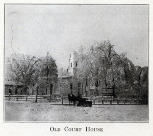
The first session of the circuit court in Porter county was held at the
residence of John Saylor in October, 1836, Judge Samuel C. Sample presiding.
When the time came for the jury to take up the consideration of a verdict, there
was no suitable room for their deliberations, and they conducted their "secret
session" under a large oak tree near the house. This showed the necessity for a
court house, but the condition of the county treasury was such that the erection
of a building commensurate with the needs of the county was out of the question.
In this emergency the citizens came to the rescue, and early in 1837 a
subscription paper was circulated to raise funds with which to erect a court
house and jail. The sum of $1,250 was soon realized and with this a frame court
house 20 by 48 feet was built on the west side of the square where the present
court house stands. A log jail was built in 1838 on Mechanic street (now Indiana
avenue), a short distance southeast of the public square. On December 17, 1870,
the county commissioners bought the lot on the southeast corner of Franklin
street and Indiana avenue for $2,200 and on March 8, 1871, let the contract for
the erection of a new jail to cost $24,325. Some twelve years later some new
cells were added and a heat-
59
ing plant installed at a cost of $4,500, giving Porter county one of the best
jail buildings in the state.
The old frame court house continued to do duty until 1850, although it was
inadequate to the county's needs, and for several years court was held in an
upper room over the postoflice. In 1850 a new court house was commenced. It was
finished in 1853, the delay having been caused by the use of unsuitable
material, a portion of the building having to be
torn down and rebuilt, yet when
completed it was considered one of the handsomest county buildings in the state.
It was 40 by 60 feet, built of brick, and cost the county $13,000. As the county
continued to grow, additions to this building became necessary, and by 1880 the
question of erecting a new building came up for consideration. In December,
1882, the board of county commissioners ordered the erection of a new court
house. The plans submitted by J. C. Cochrane, an architect of Chicago, were
accepted on April 10, 1883, and bids for the construction of the
60
building were opened at the June term following. On July 18, 1883, the board
issued the following order: "Whereupon, said proposals having been publicly
read, the Board, on due consideration of all the said proposals, do find that
John D. Wilson of Valparaiso, Indiana, is the lowest responsible bidder, and it
is therefore ordered by the board that the proposal of the said John D. Wilson
be, and the same is hereby accepted, and it is further ordered by by the Board
that the contract to build the said court house be, and the same is hereby
awarded to the said John D. Wilson for the sum of one hundred and twenty-five
thousand nine hundred and nine dollars ($125,909)."
The contract was signed on July 25, 1883, Mr. Wilson began work at once, and on
October 24, 1883, the corner-stone was laid with appropriate ceremonies, under
the auspices of Porter Lodge, No. 137, Free & Accepted Masons. The city was
gaily decorated and all business was suspended during the ceremonies. Seven
Masonic lodges, several commanderies of Knights Templars, the Grand Army of the
Republic, the Independent Order of Odd Fellows, the city fire department and a
number of brass bands participated in the proceedings. The corner-stone, 3 by 7
feet and about 22 inches thick, was laid by A. P. Charles, of Seymour, Deputy
Grand Master of the Indiana Grand Lodge. In the center of the stone is the
inscription: "Laid by the Masonic Fraternity, October 24, A. D. 1883, A. L.
5883." To the right of this are the names of the commissioners and the county
auditor, and to the left the names of the architect and contractor. Within the
stone were deposited samples of Porter county grain, a court calendar, copies of
the county newspapers, a catalogue of the Northern Indiana Normal School, a
roster of the Masonic bodies and the fire companies, historical and statistical
reports of the several townships, photographs of the county and city officials,
etc.
The dimensions of the court house are 128 feet from east to west, 98 feet from
north to south, and 168 feet to the top of the dome. It consists of two stories
and basement, the outer walls being constructed of
61
oolitic limestone from Elletsville, Indiana. On the last day of May, 1886, W. E.
Brown, then auditor of the county, made his final report as to the cost of the
building, which was $157,348.10. This was more than $30,000 in excess of the
original contract, but a number of things were included in the auditor's total
that were not a part of the contract, such as $1,451.88 for a clock and bell,
and some $10,000 for furniture and office fixtures. (See Frontispiece.)
Prior to 1855, the poor of the county were taken care of by such responsible
persons as were willing to undertake the charge, the commissioners paying from
one to two dollars per week for each indigent person. On June 7, 1855, the board
of commissioners bought from William C. Pennock, for $3,000, a tract of 120
acres of land in sections 26 and 27, township 35, range 6, for a poor farm. Soon
after the purchase was made, a contract was entered into with George C. Buel to
erect a frame house, 32 by 45 feet for a poor house, the consideration being
$2,482, of which $500 was to be paid on January 1, 1856, $1,000 on March 1,
1856, and the remainder in county bonds payable in one year and bearing six per
cent interest. The building was completed and ready for use at the time
specified in the contract - September 1, 1856, and, with several additions
continued to be the county poor house for nearly half a century. Eighty acres -
the west half of the southeast quarter of section 26 - were added to the farm in
1866, at a cost of $3,200, and in June, 1875, the commissioners purchased of W.
C. Hannah, for $1,200, "all that part of the northeast quarter of Section 35,
Township 35, Range 6, which lies north and east of Salt creek and south of a
line drawn parallel with the north line of said quarter, and distant seventy
rods and thirteen feet south therefrom; the same to be an addition to the poor
farm." Another addition was made on June 9, 1876, when the commissioners bought
for $1,200 the southeast quarter of the southwest quarter of section 27, except
ten acres off the south side.
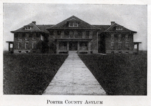
Early in 1905 the commissioners took the preliminary steps for the erection of
new buildings upon the farm by employing an architect to make plans for a
"county infirmary." The architect submitted plans
62
for a building to cost $35,000, but the county council reduced the amount to
$25,000. Consequently the plans were changed to bring the estimate within this
figure, and on August 7, 1905, bonds to the amount of $25,000, bearing four per
cent interest, were issued and the proceeds applied to the erection of the
building upon the tract of land hitherto known as the poor farm. A few citizens
were dissatisfied with the building on account of the changes in the plans to
bring the cost within the amount allowed by the county council, and there was
some talk of a
suit to enjoin the county from paying the bonds, but nothing came
of it. Since then a barn costing $4,000 has been erected on the farm. The term
"poor house" has become obsolete. With the legislation directing the
commissioners of the several counties in the state to provide suitable quarters
for certain insane persons, along with the paupers, the name "county asylum" has
been adopted. Porter county has one of the best institutions of this nature in
northern Indiana.
One of the greatest works of internal improvement ever made by the county has
been in the matter of ditches for the reclamation of swamp
63
lands. These ditches are constructed under a law similar to that providing for
the building of gravel or macadamized roads. When a certain number of
freeholders, whose lands will be affected by the proposed ditch, petition the
county commissioners for the construction of such ditch, a survey is made, the
cost estimated, and if the petition is granted bonds are issued and assessment
levied upon the lands. The oldest ditch in the county is the Reeves ditch, which
begins in section 24, township 33, range 5, and runs south to section 36, thence
west to the Kankakee river, draining an area of some eight square miles in
Pleasant township.
The Koselke system of ditches embraces practically the entire Crooked creek
valley. It begins in Washington township, about two miles east of the city of
Valparaiso, absorbs the old Hunt and Lyon ditches, and includes some seven miles
of new ditch along Crooked creek. This system drains a large area in Washington,
Morgan and Pleasant townships. Connected with the Koselke system is the Hutton
ditch in the eastern part of the county. It receives the Cain ditch, which
begins near Prattville, and the Orr ditch, beginning about three-fourths of a
mile south of Clear lake. East of the Hutton ditch is the Washington and Morgan
township ditch which drains an area of about ten square miles in the townships
from which it takes its name.
Another large system is the Phillips ditch and its branches, beginning about n
mile north of Boone Grove and running southward to the Kankakee river, draining
about fourteen sections of land in Porter and Boone townships.
Between the Koselke and Phillips ditches is the Pleasant township system, which
has its source a short distance north of the Panhandle railroad, about two miles
east of Kouts. The main ditch, with its numerous ramifications, trends
southwestward and enters the Kankakee river about half a mile west of the
Koselke ditch in section 35, township 33, range 6.
Just west of the Pleasant township system lies the Cobb or Sandy Hook system,
which drains the largest area of any system of ditches
64
in the county. This system approximates about twenty-four miles of ditch, each
mile of which drains a section of land.
To the west of the Phillips ditch is the Breyfogle and Cornell ditches in one
system. The Cornell ditch begins near the village of Hurlburt and runs southeast
to section 9, township 33, range 6, thence south to section 21 of the same
township and range, where it joins the Breyfogle ditch, which empties into the
Kankakee river about a mile and a half east of the Lake county line.
In the southwest corner of the county is the Morrow system, in which about one
mile of dike has been built - the only dike in Porter county. This system runs
westward into Lake county.
The Cook ditch has its beginning in Laporte county, on the line between
townships 32 and 33. It drains a small area in the southeast corner of Porter
county where it is being rebuilt and when completed will be known as the Keller
ditch.
Near the center of the county is the Parker ditch, which begins on the line
between Washington and Center townships and follows the course of old Salt creek
for over six miles. It takes its name from the fact that Charles H. Parker was
one of the principal factors in securing its construction. When this ditch was
opened it was noticed that it materially affected some of the wells in the
southern part of the city of Valparaiso. It forms an outlet for the sewers of
that city.
Comparatively little ditching has been done in the Calumet region in the
northern part of the county. The Tratebas ditch drains a small area of lowland
about a mile north of Woodville, in the vicinity of Mud lake. The Robbins ditch
runs through sections 18, 19 and 30, township 36, range 6, and the Samuelson
ditch runs through sections 28, 29, 30 and 31 of the same township and range.
The McDonald ditch runs through sections 14, 15, 23 and 24, township 37, range
5, and the Voight ditch drains a small area in the northeastern part of the
county between the Michigan Central railroad and Lake Michigan. However, several
large projects for draining this portion of the county are under consideration.
The greatest of these is the Burns or Calumet system, involving an ex
65
penditure of about $300,000. At this writing (June, 1912) the matter is in the
hands of the Indiana Supreme Court. If that tribunal renders a favorable
decision, and the work is completed according to the original designs, the
course of the Calumet river will be changed. The main ditch of this system will
enter Lake Michigan about three-quarters of a mile west of Dune Park.
Large sums of money have been expended in the county in the construction of
ditches, and still others are contemplated. But for every dollar thus invested
the crops from the fertile soil of the reclaimed lands have demonstrated that it
has been a profitable investment.
Railroads are not internal improvements in the sense that they were built by
appropriation of the public funds, but in Porter county they have played an
important part in the development of the county's resources. Of the 7,220 miles
of railway in the state, nearly 200 miles are in Porter county. Lines of eight
great systems pass through the county, and branches of still other systems cross
some portion or terminate within the county limits. In 1850 the Michigan Central
and the Lake Shore & Michigan Southern railways reached the eastern border of
Porter county. There was a spirited rivalry between the two companies to see
which line would first be completed to Chicago. The Michigan Central won the
victory, but by a narrow margin. The Michigan Central enters the county near the
northeast corner and runs southwest, while the Lake Shore crosses the eastern
border near the line separating Pine and Jackson townships and trends a little
north of west, crossing the Michigan Central near Chesterton. The first freight
received by rail in Porter county was a consignment of goods for Hubbard Hunt,
then a merchant of Valparaiso. These goods came on a Michigan Central
construction train in 1851 to where the town of Porter now stands, and there
were unloaded upon the open prairie.
The Lake Shore & Michigan Southern was at first called the Michigan Southern &
Northern Indiana. One of the early time cards of this road shows that it took
the fastest train on the line eight hours and a half to make the trip from
Toledo to Chicago, while the accommodation train
66
required nearly eleven hours. Some idea of the "comforts" of traveling on these
early railways may be gathered from the following descriptive article taken from
the Valparaiso Observer of November 5, 1853:
"The cars of the night express train on the Michigan Central railroad are
furnished with high-backed seats, to enable a person to lay back his head and
sleep as well as an easy rocking chair. If one has a whole seat, he can find
pretty comfortable room to lie down, and then after becoming accustomed to the
noise, can sleep very well.
The cars are lighted with what one would at first view take to be lamps, but
prove to be very large candles, probably near two inches in diameter. The
candlestick has a spring which constantly presses the candle upwards, and a
cover with a hole in the middle for the wick to stick up through, which screws
on at the top, and only allows the candle to be raised up by the spring as fast
as it burns away. This seemed to be a piece of ingenuity worthy of remark."
That was written less than sixty years ago, and the progress made in railroading
since then has been a greater "piece of ingenuity" than the invention of the
large candle with its spring candlestick. The passenger of to-day on the
Michigan Central may ride in Pullman sleeping or drawing room cars, lighted by
electricity, and take his meals in a dining car as well equipped as the best
restaurants in our large cities.
The completion of the two roads above mentioned gave to the northern part of the
county improved mail, transportation and traffic facilities, but the central and
southern portions of the county received but little direct benefit from their
construction. Consequently, an agitation was started for a line to cross the
county near the center, the citizens of Valparaiso being especially active in
the movement. By the middle of the Nineteenth century it was apparent that
Chicago was destined to be the great commercial metropolis of the Middle West,
and it was not a very difficult matter to interest capitalists in a proposition
to build a line of railway from Chicago eastward, with a view of ultimately
touching the Atlantic seaboard. The agitation culminated in the organization of
a company to build a road from Fort Wayne to Chicago. A Valparaiso
67
paper of April 7, 1853, announced that Mr. Pierce and Mr. Anthony were just back
from Fort Wayne and brought the cheering news that work on the road would begin
in a month, and that it was expected to have trains running to Chicago by the
beginning of winter. This "cheering news" was a little premature. In September,
1853, a new board of directors was elected, S. I. Anthony, of Valparaiso, being
one of the number, and the new board announced that it was hoped to have the
road completed by the fall of 1854. Again the work was delayed by various
obstacles and three years elapsed before the work really was actively begun. In
August, 1856, some eastern men became interested in the project, a new board of
directors was chosen, and the name of the road was changed to the "Pittsburgh,
Fort Wayne & Chicago." Early in 1857 the contracts for construction were relet,
and about April 1st work was commenced at Valparaiso. Later in the summer it
became rumored about that an effort was being made to have the road leave the
original survey and run by way of Laporte. This aroused the indignation of the
Valparaiso people, and late in July a meeting was held, T. A. E. Campbell
presiding, and the following resolutions were unanimously adopted:
"Resolved, That on account of the local interests involved in the
abandoning the completion of the Pittsburgh, Fort Wayne & Chicago railroad, it
is a duty of every property holder in this county to use every exertion to
expedite the work so far as his means will admit.
"Resolved, That it is now in our power to insure the completion of the
road at an early day if we come up with our purses and energies united.
"Resolved, That the reception by the Board of Directors and the
entertaining of any proposal to abandon the direct route is injurious to the
interests of the road and the acceptance of such proposals would be a breach of
faith which we would condemn as unworthy the character of gentlemen and managers
of a corporation of such extent and influence as the Pittsburgh, Fort Wayne &
Chicago Railroad Company.
"Resolved, That as a large amount of the money necessary to build,
68
the road has already been expended, and but a comparatively small amount needed
to complete the work, it should prompt us to take action lest the influences
operating against us take from us the advantages we are about to receive. We
will therefore use our influence and advance our means to keep the work moving
on the present route."
T. A. E. Campbell, S. C. Haas, J. N. Skinner, Myron Powell, Philip Hall and
George Earl were appointed a committee to canvass Porter and Lake counties and
the southern part of Laporte for money to prepare the road bed for laying the
track. Not long after the Valparaiso meeting the work was suspended "for want of
funds," but the contractors were given the privilege of continuing the work,
provided they would take the bonds of the company at seventy-five cents on the
dollar. The committee used the funds collected and subscribed to take the bonds
and the work went on according to the original plans. The track was completed to
Valparaiso about the first of October, 1858, and was finished to Chicago a year
or so later. Valparaiso now had a railroad.
In the meantime railroad lines were projected from Joliet to Laporte and from
Logansport to Chicago, to pass through Valparaiso. The former was never built
and the latter passes through the southern part of the county as the Logansport
division of the Pennsylvania system.
The Peninsular railroad reached Valparaiso in 1874. It soon passed into the
hands of the Chicago & Port Huron Railroad Company and not long afterward became
a part of the Grand Trunk system. The road was completed to Chicago in 1875.
About the time this road was being built through Porter county the Baltimore &
Ohio also came through the county. This road enters the county on the east near
the northeast corner of Washington township and runs northwest until it crosses
the western boundary about two miles south of Lake Michigan. Some trouble
occurred when this line reached the Michigan Central at Crisman in the fall of
1874. The Michigan Central disputed the right of the new road to cross its right
of way and stationed a number of men there to prevent the Baltimore & Ohio from
putting in a crossing. The latter company hurried a force of armed men to the
scene and for a little while
69
it looked as though civil war was imminent. In the end common sense prevailed
and the matter was amicably adjusted.
In 1881 the New York, Chicago & St. Louis line was completed through the county
to Chicago. This road is popularly known as the "Nickel Plate," which name it is
said to have received from the following incident: The road was built by Calvin
Brice, at that time the head of the Lake Erie system, and, as soon as it was
completed, he offered it for sale to the Vanderbilt interests. When asked to
name his price he suggested a figure that to Mr. Vanderbilt seemed exorbitant
and he replied: "Why, Brice, I wouldn't give that for your old road if it was
nickel plated." However, Brice held the whip hand, the road was threatening to
become a dangerous competitor to the Vanderbilt lines, and in the end Mr.
Vanderbilt purchased at the original figure. Mr. Brice then told the story, and
since that time the road has been known as the Nickel Plate. It crosses the
county from southeast to northwest through Valparaiso and Wheeler.
Not long after the building of the Nickel Plate came the Chicago & Erie, which
enters the county about three miles north of the southeast corner and runs
northwest into Lake county. The principal stations on this road in Porter county
are Kouts, where it crosses the Panhandle, Boone Grove and Hurlburt.
The Wabash railway (formerly the Montpelier & Chicago) enters the county from
the east near Clear Lake, runs northwest to Morris, thence west via Crocker and
McCool, and crosses the western boundary a short distance south of the Baltimore
& Ohio.
About the beginning of the present century the Chicago, Cincinnati & Louisville
(now the Chesapeake & Ohio) was built through the county parallel to and about
four miles north of the Erie. Malden and Beatrice are the leading Porter county
stations on this road.
In addition to these main lines the Elgin, Joliet & Eastern enters the county on
the west, about a mile north of the Pittsburgh, Fort Wayne & Chicago, and runs
northeast to Chesterton; a branch of the Pere Marquette system runs from
Chesterton northeast into Laporte county; the
70
Chicago & Eastern Illinois crosses the extreme southeast corner. and a branch of
the New York Central Lines has been extended to Dune Park . Then there are the
Chicago, Lake Shore & South Bend and the Valparaiso & Northern electric lines,
the former running almost parallel to the Michigan Central across the county,
and the latter running from Valparaiso to Chesterton, where it connects with a
line running to Michigan City. Other electric lines are under construction or
contemplated. These numerous steam and electric roads furnish excellent
transportation facilities to all sections of the county.
The following table, compiled from the county auditor's report, shows the
valuation of railroad property at the close of the year 1911:
|
Center township . . . . . . . . . . . . . . . . . . . . . |
$701,650 |
|
City of Valparaiso . . . . . . . . . . . . . . . . . . . . |
308,640 |
|
Union township . . . . . . . . . . . . . . . . . . . . . |
850,220 |
|
Washington township . . . . . . . . . . . . . . . . |
888,960 |
|
Jackson township . . . . . . . . . . . . . . . . . . . . |
484,660 |
|
Liberty township . . . . . . . . . . . . . . . . . . . . . |
328,530 |
|
Portage township . . . . . . . . . . . . . . . . . . . . |
1,407,690 |
|
Westchester township . . . . . . . . . . . . . . . . |
946,350 |
|
Chesterton . . . . . . . . . . . . . . . . . . . . . . . . . . |
191,270 |
|
Town of Porter . . . . . . . . . . . . . . . . . . . . . . |
296,190 |
|
Pleasant township . . . . . . . . . . . . . . . . . . . |
828,530 |
|
Porter township . . . . . . . . . . . . . . . . . . . . . |
214,000 |
|
Boone township . . . . . . . . . . . . . . . . . . . . . |
570,460 |
|
Hebron . . . . . . . . . . . . . . . . . . . . . . . . . . . . . |
36,760 |
|
Morgan township . . . . . . . . . . . . . . . . . . . . |
176,720 |
|
Pine township . . . . . . . . . . . . . . . . . . . . . . . |
669,730 |
|
Total . . . . . . . . . . . . . . . . . . . . . . . . . . . . . . . |
$8,900,360 |
NAVIGATION OF
1912 HISTORY OF PORTER COUNTY
PREFACE
CONTENTS
CHAPTER I - General Features
CHAPTER II - Aboriginal Inhabitants
CHAPTER III - Settlement and Organization
CHAPTER IV - Internal Improvements
CHAPTER V - Educational Developments
CHAPTER VI - Military History
CHAPTER VII - Township History
CHAPTER VIII - Township History (continued)
CHAPTER IX - The City of Valparaiso
CHAPTER X - Financial and Industrial
CHAPTER XI - The Professions
CHAPTER XII - Societies and Fraternities
CHAPTER XIII - Religious History
CHAPTER XIV - Miscellaneous History
CHAPTER XV - Statistical Review
Transcribed by Steven R. Shook, November 2011