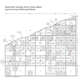
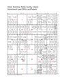
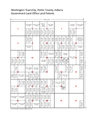
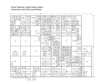
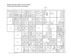
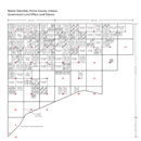
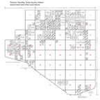
Land Patent Plat MapsPorter County land patent plat maps based on GLO data . . . .
Land patents were issued by the General Land Office, conveying property held by
the federal government to individuals. An individual receiving a patent was
referred to as a patentee. The most common types of land patents issued in Porter
County included Cash Entry Land Patents, Homestead Land Patents, and Military
Warrant Land Patents.
A total of 2,638 land patents are recorded on the
township maps provided below, which you can search to find original owners of
Porter County land. You can also search by patentee name using the
Porter County Land Patent Name Index; this index also provides copies of the
original land patent document issued by the federal government.
Clicking on a township map below will open a copy of the
township land patent map in
Adobe Acrobat pdf file format. Upon examination of the maps, you will note
that many tracts of land do not list a patentee's name. In these cases, the land
was either held in reserve by the federal government, transferred to the state
for disposition, or held in public good for uses such as school land or
railroads.
If you have questions or comments regard the land patent maps presented on this
website, then please contact the
Porter County GenWeb Coordinator.
Source Citation:
Department of Interior, Bureau of Land Management, General Land Office,
Federal Land Patents.
 Portage (North)  Portage (South) |
 Westchester |
 Pine (North)  Pine (South) |
 Liberty |
 Jackson |
|
 Union |
 Center |
 Washington |
 Porter |
 Morgan |
 Boone |
 Pleasant |
General Land Office plat maps prepared for web by Steven R. Shook,
October 2011