1976 Historic Structure Report - Bailly CemeteryHistoric Structure Report for the Bailly Cemetery, 1976 . . . .
The following is a complete transcription of a historic structure report for the
Bailly Cemetery published in December 1976 by the United States Department of the
Interior, National Park Service. The report provides significant information
concerning the history of Bailly Cemetery.
Source Citation:
Clemenson, A. Berle, Kenneth W.
Bennett, and Catherine H. Blee. 1976.
Historic Structure Report, Bailly Cemetery:
Historical, Architectural, and Archeological Data, Indiana Dunes
National Lakeshore, Indiana. United States Department of the Interior,
National Park Service, Historic Preservation Division. Denver, Colorado: United
States Department of the Interior. 85 p.
HISTORIC STRUCTURE REPORT
BAILLY CEMETERY
HISTORICAL, ARCHITECTURAL, AND ARCHEOLOGICAL DATA
INDIANA DUNES NATIONAL LAKESHORE
INDIANA
Prepared by
A. Berle Clemensen
Kenneth W. Bennett
Catherine H. Blee
DENVER SERVICE CENTER
HISTORIC PRESERVATION DIVISION
NATIONAL PARK SERVICE
UNITED STATES DEPARTMENT OF THE INTERIOR
DENVER, COLORADO
December 1976
1
I. ADMINISTRATIVE DATA
2
Below is the administrative data supplied by Indiana Dunes National Lakeshore,
which includes an initial listing of structure title, number, specific location
within the park, and date or period or cultural significance.
A. Name and Number of Structure
Title: Bailly Cemetery
Number: 34-100 - Cemetery
Location: Bailly Unit
Period: 1910-1915
Significance: Bailly family and others were buried there
Historian Berle Clemensen, Historic Preservation Division, DSC, inspected Bailly
Cemetery in October 1975 for the purpose of making recommendations regarding the
portion of the Bailly Unit to be included on the National Register. His
determination relative to the undefined scope of the term "Bailly Homestead" was
that it referred only to the five-building enclave adjacent to the Little
Calumet River, thus excluding the cemetery. He believes this latter area to be
of Third Order of Significance.
B. Proposed Use of Structure
The historic structure report (1972) prepared by Harry Pfanz and T. Russell
Jones recommends restoration to the period of 1910-1917, based on the historic
photograph on page 81 of that report. Generally, the cemetery will be restored
to its appearance after final alterations were made in 1915. Work will include
replacement of the concrete railings on the upper terrace, reconstruction of the
wooden cross, repair walks and walls, clean-up, removal of existing vegetation,
and the planting of new flora, thereby reestablishing the appropriate historical
landscape.
C. Provision for Operating Structure
Proposed use of the structure in the context of operations and management
requirements will be confined to visitor use and interpretation. Park staff
concurred with the advisement that the cemetery must be secured from vandalism.
How this will be accomplished will be determined later. A regular maintenance
schedule will be instituted by park management to facilitate the cemetery's
general maintenance requirements.
D. Cooperative Agreement, if Any, Executed or Proposed for Operating
Structure
Cooperative agreements have been made with NOPAC for ambulance service and with
the town of Porter for fire protection.
Associated documents such as master plan and resource studies bear on
furnishing, management, and use of the structure. These pertinent documents are
listed here with their respective dates:
3
Master Plan, 1969
Interpretive Prospectus, 1972
Historic Structure Report, 1972, H. Pfanz and T. Russell Jones
4
[blank page]
5
II. HISTORICAL DATA
by
A. Berle Clemensen
6
A. Preface
This general account and structural history of Bailly Cemetery has been written
to provide information for its interpretation and preservation.
My thanks are extended to Superintendent Whitehouse of the Indiana Dunes
National Lakeshore and his staff and to the Porter County Historical Society for
their research aid.
B. Statement of Significance
Bailly Cemetery is the oldest white cemetery in Porter County, Indiana.
Tombstones indicate the earliest burial date to be 1811. The Bailly family, one
of the first to settle in the area, made its claim to the plot with the
interment of Robert Bailly, Joseph Bailly's son, in 1827. They claimed the
cemetery as their private burial place in 1866 although neighbors continued to
use it until the early 1870s. Concern for privacy led the Bailly descendents to
build this unique walled cemetery.
C. Introduction
Frenchmen were the first whites to travel through northern Indiana. Marquette
passed the Dunes area of northern Indiana as early as 1675. In the 1750s the
French constructed the Petite Fort near the mouth of Fort Creek in what is now
the Indiana Dunes State Park. By this time the Potawatomi Indians dominated the
Calumet area with some Ottawa and Miami also inhabiting the region.
White men utilized the Indian trails -- the first commonly used routes in the
area. In the period 1803-36 the principal road from Detroit to Fort Dearborn
followed the main Sauk Trail to its northern branch, then on to Chicago via the
Lake Shore (Calumet Beach) Trail. The northern branch of the Sauk Trail crossed
the Bailly area on a southeast to northwest course. In 1837 the Detroit-Chicago
road changed to follow the Calumet Beach Trail. This latter route passed just
north of Joseph Bailly's homestead. Present-day Highway 12 approximately follows
this trail.
Joseph Bailly was born on April 8, 1774, into a long established French family
in Quebec. As a young man he chose a profession in the fur trade. In 1798 he
married an Indian woman by whom he fathered five boys and a girl, but in 1810 he
left this wife and took a second. With this half French, half Ottawa woman,
Marie LeFevre de la Vigne, he later settled in the Calumet region of northern
Indiana.
Bailly's name first emerged in connection with the area south of Lake Michigan
during the War of 1812. On March 17, 1813, a representative of the British Army,
Robert Dickson, wrote Bailly asking for his assistance in winning the Indians of
that region to the British cause. Bailly agreed. In June 1814 he began to supply
the Indians with goods to encourage them into a British alliance. Late in that
year the American forces captured Bailly as
7
he entered the area with more merchandise. Bailly's work for the English netted
him three months in prison. Three days after his release he billed the British
for his services and losses, but there is no record of reimbursement.
By 1916 Bailly faced hardships in his livelihood. In that year Congress
prohibited Canadians from participating in the American fur trade. As an
expedient Bailly became an American citizen. Naturalization brought him
employment in 1818 with the American Fur Company at its Mackinac Island
headquarters.
Evidently dissatisfied as a hireling of the American Fur Company, Joseph Bailly
became a free trader in 1821. He received a fur trading license for the Calumet
region of Indiana where he located the Bailly homestead.
Bailly entered northern Indiana in 1822 and chose a good location for his fur
trading post near the intersection of two Indian trails (the Calumet Beach and
the northern Branch of the Sauk Trail). Fur trading in the area, however, had
declined. It reached a nadir for Bailly in the period 1828-30. The American Fur
Company, his major market, recorded no business with him in that period except
charges of interest on past debts. Evidently to augment his limited income from
furs, Bailly opened a tavern nearby on the northern branch of the Sauk Trail,
which formed the main Chicago-Detroit road at the time.
The Potawatomi Treaty of 1826 placed the Little Calumet River area in the public
domain. In 1829 United States surveyors established section lines in the area of
the Bailly homestead. Joseph applied for a land title, and on September 6, 1831,
he was conveyed by patent the SE 1/4 of Section 27, Township 37, Range 6 West.
On this 159.80 acres of land Bailly had his homestead. The cemetery, which
carried the family name, was located north of the home site.
D. Structural History
The burial ground, comprising about two acres, is located on a sand hill bout
three-fourths of a mile north of the Bailly home buildings. Its Survey Plat
location is the NE 1/4 of Section 27, Township 37, Range 6 West. The plot
derived its name from the numerous Bailly family graves located there, as well
as from Bailly ownership and maintenance of the site. Jacob Stair, however,
first owned the land on which the cemetery was located, having purchased it on
July 8, 1834. Stair deeded the property to Therese Vigne, Joseph Bailly's
stepdaughter, on February15, 1839, after she paid the delinquent taxes. Joel
Wicker, Bailly's son-in-law, obtained the land in 1856, passing it to Rose
Bailly Howe in March 1864. She owned it until her death in 1891, at which time
her daughter Frances R. Howe acquired the title. Following her death, the
Danielson family purchased the land; they deeded it to the Michigan City
Historical Society in 1949. In 1971 the United States government acquired the
property.1
8
Indians reportedly first used the site for their dead.2 Although some
skeletons have been uncovered on several occasions, they have been reburied
without a determination of their race. As a result no one has established that
the hill originally served as an Indian burial ground.
Joseph Bailly's granddaughter, Frances R. Howe, claimed the first interment
occurred in 1827 when Bailly buried his ten-year-old son Robert.3
However, it is very doubtful that this boy was the first white entombed there.
Just outside the present cemetery wall on the north are tombstones containing
eight names. Four of these markers have dates preceding 1827, the year Robert
Bailly died. These include: Isaac Schellinger, 1811; Peter Carlbon, 1814; Rhoda
Schellinger, 1816; and Thomas B. Speer, 1817.
In 1827 Joseph Bailly chose the sand hill as the resting place for his son
Robert. Near the grave he placed a a large oak cross, which travelers on the
nearby trail could easily view. Bailly constructed a small log shelter in front
of the cross that served as protection for those who wished to pray there.4
Joseph Bailly, his wife Marie, and all their daughters have since been buried in
the cemetery. A stepdaughter, son-in-law, and several grandchildren were also
interred there. In addition, numerous Swedish immigrants used the hill for their
dead.5
Two months before Marie Bailly's death in September 1866, her daughter, Mrs.
Rose Bailly Howe, enclosed the area around the family graves with a wooden
fence. At the same time she restricted the cemetery to Bailly family members and
asked the neighbors to remove their dead,6 but few complied. Instead,
during the absence of Mrs. Howe and her daughters in Europe (1869-1874),
non-family graves increased: three Swedish immigrants were buried there in that
period.7
Upon her return from Europe Mrs. Howe was evidently distressed to find how
little the neighbors had cooperated to convert the hill into a private
9
family cemetery. Maintenance of the enclosed family plot offered an alternative
method to delineate family graves from the others and afford some privacy. In
1878 she contracted with John Peter Nord to keep the fence in repair and weed
the enclosure twice a year.8
Privacy for the family graves increasingly concerned Mrs. Rose Bailly Howe after
her daughter Rose died in 1879. In the early 1880s Mrs. Howe had the wooden
fence removed and the area encompassed with a six-foot limestone wall topped
with iron spiked. A seven-foot-wide two-door iron gate on the south guarded the
driveway entrance. Fastened to three inside walls were wooden cabinets with
rounded tops and a cross over each. Figures inside each cabinet depicted the
stations of the cross. Additionally, each cabinet had a kneeling bench beneath
it. An altar was located in the southeast corner. "Graveyard Myrtle" gave the
enclosure a subtle fragrance. Trees and other "Sweet-Smelling" plants also grew
inside the walls.9
Since the original cross placed on the site by Joseph Bailly had decayed, Mrs.
Howe decided to replace it with a replica. A a ceremony in December 1884 she
dedicated the new cross, which was centered on the north atop a rough stone
mound.10 The cross beam was supposedly notched into the vertical
column and held in place with a strap of iron bolted to it.
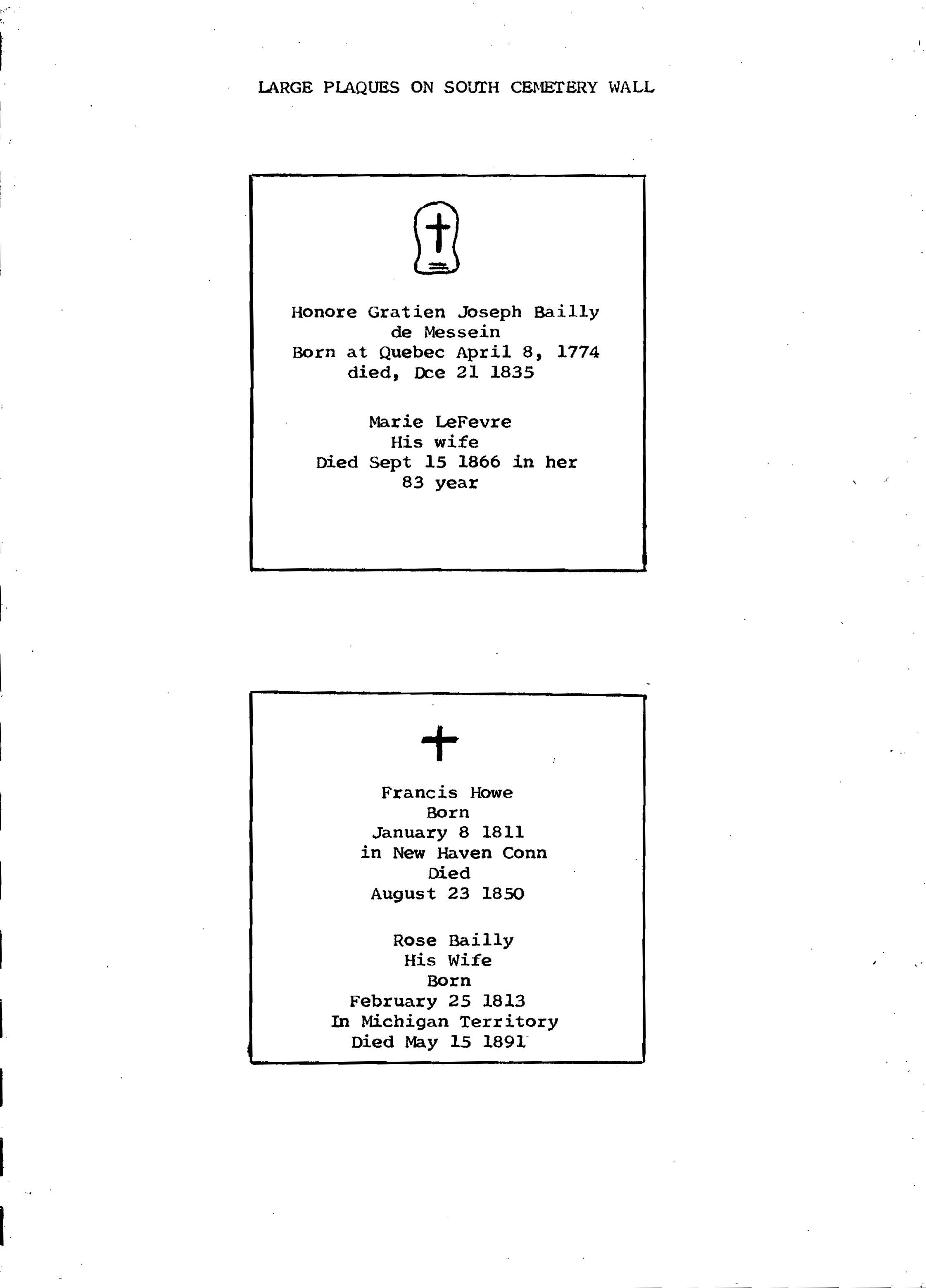
A short time after the death of Mrs. Rose Bailly Howe in May 1891, her daughter,
Miss Frances R. Howe, had two plaques measuring about three by five and one-half
feet emplaced in the north wall. One bore the names of Joseph and Marie Bailly
and the other those of Francis and Rose Bailly Howe. In addition, two nearby
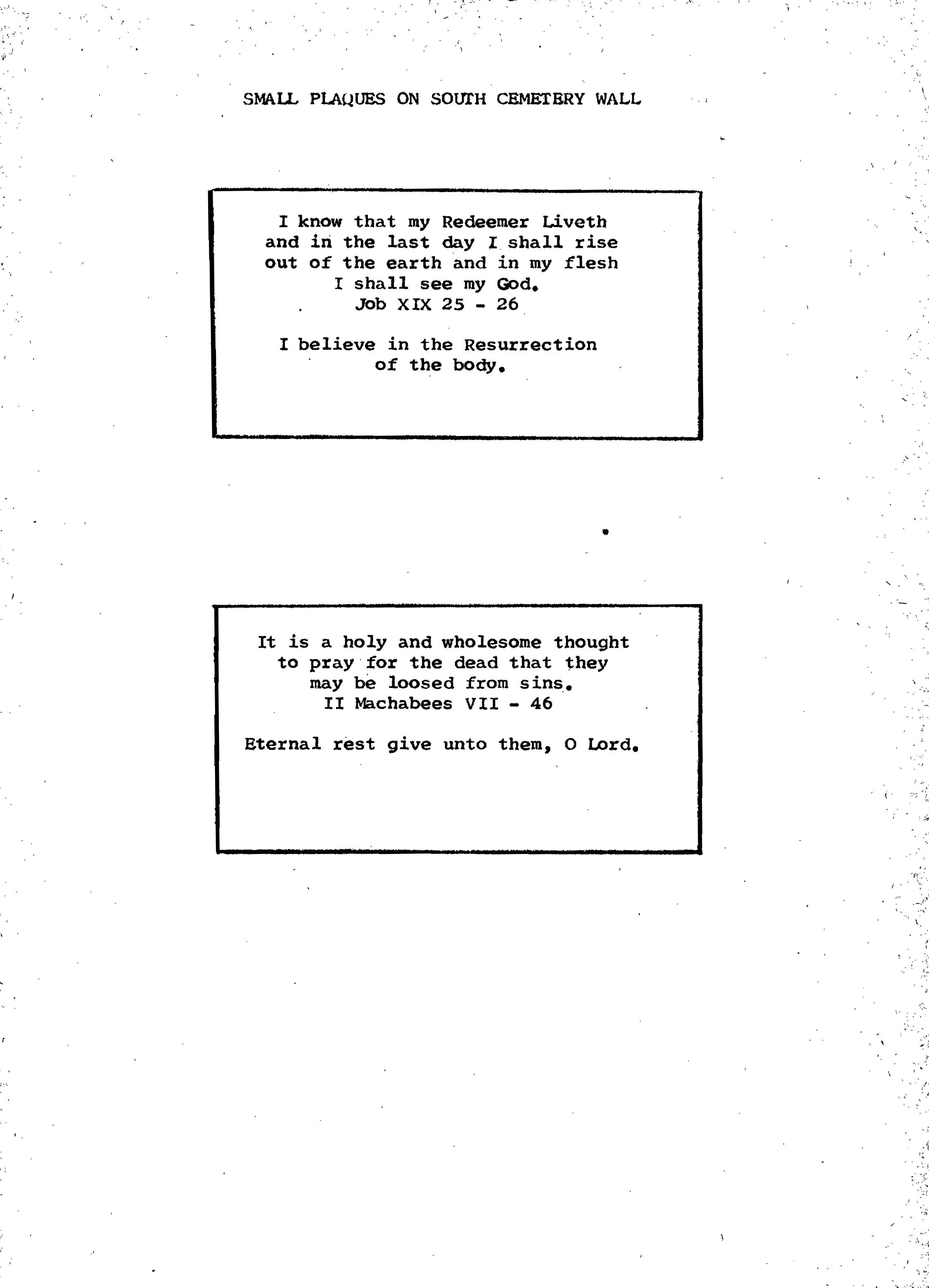
smaller plaques carried biblical inscriptions. About this same time Miss Howe
evidently had a low cross placed opposite the large one.11
The graves of Joseph and Marie Bailly were located near the large cross at the
north center of the cemetery. Their son's grave was to the east while to the
west were the graves of Francis Howe and his wife Rose Bailly, their daughter
Rose, and four of their other children who died in infancy. A second row of
graves to the south marked the resting place of other family members.12
10
Most graves had thin slab stone markers that bore the occupant's name and the
dates of birth and death.13
In 1914 Miss Frances R. Howe contracted with Theodore Stephens of Chesterton,
Indiana, to change the cemetery. Worried about vandalism, she wished to adopt a
Roman-style plan. Stephens constructed a new concrete block wall, with top
spindles and coping, around the old one. He filled the six to eight inches of
space between the walls with concrete. On the north a stairway led to the top.
Before filling the interior with sand he removed the cabinets and several
plaques from the north wall. At Miss Howe's request he left the large plaque
with Francis and Rose Bailly Howe's names in place. The plaques and a duplicate
of the one left inside were fixed to the south exterior of the new wall. In
addition Stephens laid some tombstones on the graves and placed others against
the wall.14
Stephens circled the cemetery wall at a distance of some ten feet with a
concrete retaining wall. About nine feet beyond the retaining wall he placed a
second similar wall. Miss Howe intended to use the space between the two walls
as a roadway, but she died before it could be completed.15 In
addition Frances How had the area to the highway and around the wall landscaped
with "grave plants." Besides grass, colored flowers topped the cemetery.16
Miss Frances Howe purchased a Spanish pine cross in California to adorn the
remodeled cemetery. When the cross arrived, Stephens assembled it. He placed the
fifteen-foot-high cross facing north near the center, atop the enclosure.17
Frances R. Howe's death on January 20, 1917, ended the line of Bailly
descendents occupying the homestead. Her body, the last to be interred in the
cemetery, was buried in the northwest corner. The metallic coffin was enclosed
in a dark-brown oak box with copper trim.18
The Danielsons, who purchased the property after Miss Howe's death, allowed
their livestock to graze up to the west and south sides of the cemetery
11
wall. The animals, as well as time, undoubtedly destroyed much of the landscape
vegetation placed there by Theodore Stephens.19
12
APPENDIX
Family Interments in the Bailly Cemetery
Joseph Bailly: 1774-1835
Robert Bailly: 1817-27 (son of Joseph and Marie Bailly)
L'Arbre Croche Infant: 1815-15 (legendary son of Joseph and Marie Bailly
interred in the Bailly Cemetery in 1827)
Esther Bailly Whistler: 1811-43 (daughter of Joseph and Marie Bailly)
Therese de la Vigne (?)-1843 (daughter of Marie Bailly by her first marriage)
Hortense Bailly Wicker: 1823-55 (daughter of Joseph and Marie Bailly)
Marie LeFevre de la Vigne Bailly: 1783-1866 (wife of Joseph Bailly)
Francis Howe: 1811-50 (husband of Rose Bailly Howe)
Rose Bailly Howe: 1813-91 (daughter of Joseph and Marie Bailly)
Frank Howe (infant son of Francis and Rose Howe)
Infant (son of Francis and Rose Howe)
Eleanor Howe (infant daughter of Francis and Rose Howe)
Infant (daughter of Francis and Rose Howe)
Rose Howe: 1842-79 (daughter of Francis and Rose Howe)
Two nephews of Rose Bailly Howe
Frances R. Howe: 1851-1917 (daughter of Francis and Rose Howe)
13
BIBLIOGRAPHY
Books and Articles
Howe, Frances R. The Story of a French Homestead in the Old Northwest.
Columbus, Ohio: Press of Nitschke Bros., 1907.
Moore, Powell A. The Calumet Region: Indiana's Last Frontier.
Indianapolis: Indiana Historical Society, 1959.
Nelson, C. W. "The Bailly Cemetery." (1949). MS, Reed Folder, in files of
Indiana Dunes National Lakeshore Park.
Russell, Carl P. "The Independent Fur Traders of Northern Indiana." (1962). MS,
in files of Indiana Dunes National Lakeshore Park.
Schiemann, Olga. "Historical Notes." (1952). MS, in files of Indiana Dunes
National Lakeshore Park.
Stephens, Theodore. "Bailly Cemetery - Roman Style." Duneland Historical
Society, Living Biographies 2, no. 4 (May 1956).
Letters
Lamb, W. Kay (Dominion Archivist, Public Archives of Canada), to Earl H. Reed,
1959.
Newspapers
Chesterton (Ind.) Tribune.
14
[blank page]
15
ILLUSTRATIONS AND MAPS
16
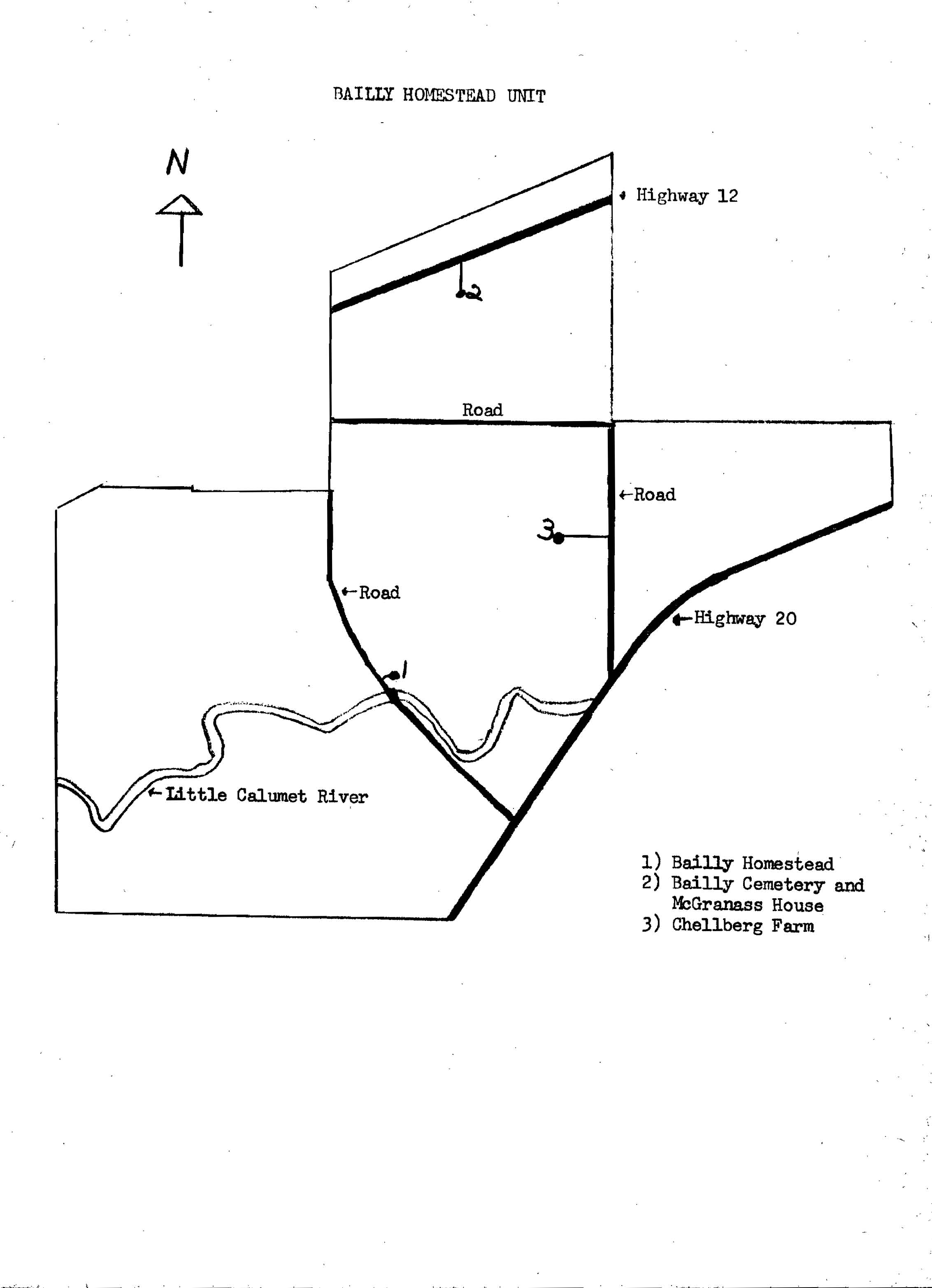
Illustration 1.
Bailly Homestead unit.
17
[Click to Enlarge]
18
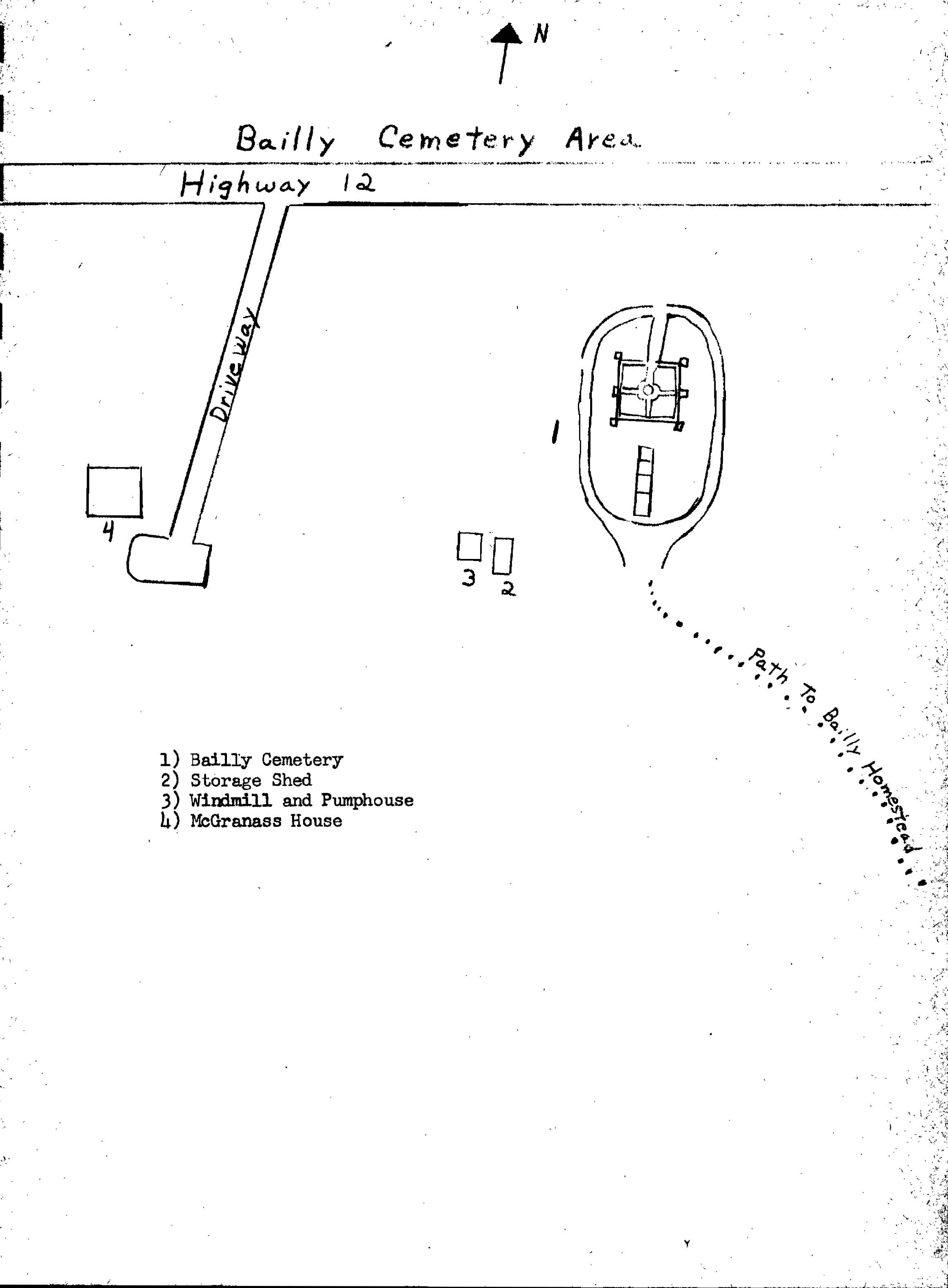
Illustration 2.
Bailly Cemetery area.
19
[Click to Enlarge]
20
Illustration 3.
Large plaques on south cemetery wall.
21
[Click to Enlarge]
22
Illustration 4.
Small plaques on south cemetery wall.
23
[Click to Enlarge]
24
[blank page]
25
III. ARCHITECTURAL DATA
by
Kenneth W. Bennett
26
A. Acknowledgments
While working on this project, the author became increasingly aware of the value
of conversing or working with specific individuals or groups who have shown
themselves to be highly competent and, most notably, very cooperative. Those
persons with whom he had continuous contact and upon whom he relied heavily for
assistance should be acknowledged at this time. They include fellow Denver
Service Center co-workers and the entire staff of the Indiana Dunes National
Lakeshore, without whose sincere and concentrated efforts this report could not
have been properly completed. Thanks go to those persons who contributed greatly
toward the production of this report.
B. Introduction
The Bailly Cemetery, which has regional historical significance as well as a
direct historical relationship with the Bailly complex, is located 0.8 miles
north of the five-building enclave and some 200 feet south of U.S. Highway 12.
This positions it approximately one quarter of a mile west of the junction of
U.S. 12 and Mineral Springs Road. Geographically the cemetery is situated in
Porter County in the NE 1/4 of Section 27.
In part, this area served as a burial site for the Joseph Bailly family. The
selection of this site was probably based on its close proximity to an existing
historic (and possibly prehistoric) burial plot. Considerable conjecture still
exists today as whether the mound on which the cemetery now stands was used as a
prehistoric burial site. Evidence in the form of unidentified human bones offers
little in the way of authentication, but does sustain the possibility that such
was the case.
The original configuration of the cemetery has been transformed by three basic
alterations, not to mention several intermediate changes. First the burial plot
was enclosed with a wooden fence ca. 1837. The second transformation occurred
about 1880 or 1881 when the wooden barrier was removed and a six-foot limestone
wall crowned with iron spikes was erected. The area assumed its final appearance
in 1915 when a rusticated concrete block facade was placed around the dressed
limestone wall. In conjunction with the newly constructed wall facade, a precast
concrete balustrade was assembled atop the rusticated stonework. A stairway was
also built leading from the north wall to the perimeter roadway. The exposed
interior was then filled with sand, landscaped with walkways and flora, and
accented with a visually dominant and centrally located standing cross. Reverend
Carlson, in his report, assessed the height of the cross's vertical column at
about fifteen feet. However, judging from the available photographic evidence,
an estimate of fourteen feet would be more accurate.
Because of numerous evolutionary changes, the writer will restrict his
commentary to the two primary and most architecturally significant cemetery
configurations. All major aspects of those two restorations proposals will be
covered in the test of this report.
27
C. Appearance
1. Structural Development for Ca. 1910 Appearance
The cemetery's ca. 1910 appearance was reflective of the 1880s modification that
involved the complete enclosure of the burial plot by a six-foot-high limestone
wall. Inserted into the concrete cap, which topped the limestone wall, were
regularly-spaced iron spikes. A single access was left in the south wall in the
form of a seven-foot passageway secured with a double iron gate mantled with
spikes. Wooden cabinets, each displaying a figurine; kneeling benches; numerous
crosses; and an altar were contained within the necropolis1 along
with a random arrangement of grave sites and their respective headstones. Not
all the grave sites were enclosed during this 1885 modification. Landscaping
probably entailed periodic clearing of indigenous undergrowth. Construction
components incorporated into this particular alteration were:
(a) A six-foot limestone wall topped with iron spikes
(b) A seven-foot-wide iron entrance gate with spikes
(c) Wooden cabinets with rounded tops and a cross over each
(d) Figurines, sheltered within each cabinet, depicting the
Stations of
the Cross
(e) A cross topping a rough stone mound marking the grave of
Joseph
Bailly's son
(f) Ground cover, unknown
2. Structural Development for Ca. 1915 Appearance
In 1915, as today, the landscape revealed an elevation rise in the form of a
mound capped by a vertical seven-foot cemetery wall rectangular in shape and
measuring fifty-eight feet four inches by forty-nine feet ten inches. Buttresses
are situated at all four corners with intermediate ones located approximately in
the center of the two longer sides. Two additional buttresses are located
immediately opposite each other at the furthermost extension of the double
abamurus that flanks a concrete stairway.
Grading immediately surrounding the four enclosed walls is elliptically belted
by a roadway defined by concrete retaining walls, with the inner wall forming a
terrace. In actuality, the roadway constitutes one terrace with the roadway's
inner retaining way supporting the second terrace. Both then are ascended by a
third terrace that is formed by the sand-filled cemetery wall. The outer roadway
retaining wall has collapsed or noticeably shifted due primarily to later
grading loads and natural soil erosion.
Steps centrally and perpendicularly abut against the north elevation plane and
lead from the first terrace to the top of the rusticated concrete block wall
coping. Inside the rusticated concrete block coping -- the highest horizontal
plane -- are walkways enclosing and quadrifiding the san-filled interior. These
four walkways radiate from a central , open hub and bisect the length of each
28
perimeter wall. Located approximately at the center and inscribed within the
curbed, circular sidewalk forming the open hub is a concrete-capped limestone
footing that once supported the fourteen-foot wooden cross. The cross has since
been partially destroyed either through general neglect or vandalism, as has the
precast concrete balustrade that was situated atop the precast rusticated
concrete block. The cemetery took on this appearance, which it retains today, as
a result of a construction contract let by Mrs. Howe ca. 1913. The present
ground cover does not resemble what was there immediately following the
cemetery's modification.
The term "grave plant" was used to describe the type of foliage adorning the
second terrace, with grass denoted as the prevailing ground cover for the upper
terrace. The first terrace or unfinished roadway was for the most part devoid of
ground cover because it served as a visitor access to the cemetery grounds.
Construction components incorporated into this alteration, including those that
were removed, include:
(a) A rusticated precast concrete block
(b) A precast concrete balustrade
(c) A stairway
(d) A fourteen-foot "Spanish pine" cross
(e) A new concrete duplicate wall plaque
(f) Sand filling of the previously open necropolis
(g) Concrete walkways
(h) Two precast rusticated block grave site enclosures
(planters)
(i) Roadway retaining walls
(j) New landscaping
(k) Removal of double gate
(l) Removal of coping spikes
(m) Removal of wooden cabinets
(n) Removal of an altar
D. Anticipated Use
The cemetery will complement the five-building historic river setting, serving
as the concluding chapter to the Bailly story. Upon rehabilitation it will be
utilized for visitor and interpretive use as it relates to the nearby Bailly
Homestead site.
E. Existing Structural Components
Below is an itemized listing of all major structural components. Their present
conditions will be elaborated upon in the succeeding paragraphs:
(1) Limestone wall
(2) Buttresses
(3) Precast rusticated concrete block facade
(4) Stairway
(5) Balustrade
(6) Retaining walls
29
(7) Wall footings
(8) Concrete walkways and curbing
(9) Landscaping
1. Existing Conditions
a) Encased Limestone Wall
It is presently impossible to make a thorough assessment of this wall's
stability, but it has been deduced through a superficial examination that the
wall is structurally sound and intact.
b) Buttresses
A typical detail, these are composed of an outer facing of bonded precast
rusticated concrete block and an inner core of what is probably heavy aggregate
concrete fill. All buttresses inner cores appear to be stable, but the exposed
block facing shows partial area of spalling and mortar deterioration.
c) Concrete Block Facade
The precast rusticated facade's existing condition reflects a natural sequence
of deterioration due to general neglect coupled with sporadic attacks of
vandalism. The rusticated surfaces of the blocks show evidence of spalling as
does the concrete cap that tops them. Areas comprising, or immediately adjacent
to, those buttressed portions of the wall have sustained more noticeable damage,
primarily because of of moisture-absorbing tendency enhanced by the absence of
direct sunlight for drying. The presence of fungi on exterior surfaces of the
precast concrete block facade contributes to the blocks' degeneration.
The molded precast concrete coping mantling the rusticated block wall has
succumbed as a result of years of idle use and abuse. Segments of coping are
either missing, in the process of fracturing, or entirely absent. The cellular
configuration of the precast concrete coping contributes to overall
deterioration by permitting water to pool within its built-in cavities. Also
included among internal wall structural variables is the condition of the mortar
or its absence. Partial mortar erosion is found within specific area. Present
determinations indicate minimum impact on the wall from grade erosion. However,
root systems extending into and behnd the wall facade create a structural
problem because the cellular blocks provide them with a source of moisture.
d) Stairway
The stairway is composed of a series of fourteen seven-inch risers and thirteen
fourteen-inch treads, all of concrete. General condition would be classified as
good although there is nominal tread wear and weathering. A single tread
indicates concrete fracturing at its leading edge.
e) Balustrade (rails and pedestals included)
Balustrade components are a precast concrete material with individual block rail
units consisting of three full cells and two half cells, each measuring two
30
feet by one foot by eight inches. The pedestal is a solid concrete casting about
on foot seven inches high by a variable perimeter not exceeding a
five-and-a-half-inch square. Destruction of the balustrade can be attributed to
periodic vandalism.
f) Retaining Walls
Taking the form of concentric modified ellipses, the eight-inch-thick, formed,
poured concrete double retaining walls seem structurally sound on the western
half but are failing on the eastern half. Major factors influencing this decline
are extensive soil erosion occurring on the downgrade side of the outside wall
and lateral grade pressures from the ascending terraces. These two factors have
contributed to the wall's vertical fracture lines, its downgrade leaning, and
even to the degree of sectional collapses of the outer wall. Evidence would
indicate that the peripheral tree line is causing subgrade disturbance by
natural root system expansion in specific areas along the outer wall.
g) Block Facade Wall Footings
The existing wall footings were found to be approximately three feet deep, thus
reveling why there is currently little evidence of wall movement. There is no
visible evidence of concrete reinforcing. The finished nine-inch upper portion
of concrete footing discloses the use of wooden forms in contrast to the lower
bulk portion, which is pit formed. The thickness of footing could be estimated
in excess of fifteen inches. In summation, the footing are in excellent
condition and would require only minimal restoration attention.
h) Concrete Walkways and Curbings
These radial, grooved, six-foot-wide concrete walkways atop the necropolis are
continuous in form, but because of the sand fill, settlement has caused some
fracturing and a certain amount of crumbling. The five-inch-wide curb embracing
the centralized circular walkway is generally intact, as is the perimeter
walkway abutting against the precast exterior wall coping.
i) Landscaping
The landscaping consists of a conglomerate of undergrowth, none of which would
be considered historical. No care has been taken to retain the growth existing
at the time of the cemetery's greatest use.
Those gravestones that are visible are widely scattered throughout the second
terrace level, with the probability that others are buried nearby. The exposed
gravestones are in a state of partial deterioration due either to weathering or
vandalism or both.
31
F. Restoration Alternatives
1. Materials and Their Application, Ca. 1910 Restoration
Materials to be utilized are dictated by applicable needs and are identified in
the following commentary.
Most notable would be the complete excavation of the sand filled necropolis,
which would also entail exhuming a grave. A second major consideration would be
the required removal of the rusticated concrete block facade and the immediate
damage this would cause to the historic limestone wall. Upon exposure of the
wall, a tested stone preservative might be applied to neutralize further decay.
The above procedure would follow necessary stone replacement and subsequent
repointing. Identification and relocation of graves and their respective markers
would be a prerequisite for restoring the historical integrity of the site. A
passageway through the south elevation of the necropolis would have to be
reintroduced, with the concomitant installation of a reconstructed heavy
wrought-iron double gate. Iron spikes would also have to be reinserted into the
cap atop the limestone wall. Demolition of the double retaining walls, stairway,
and concrete walkways would be required because they intrude on the ca. 1910
setting. As a follow-up to the termination of demolition activities, grade
restoration would be required. Period ground cover is unknown.
2. Materials and Their Application, Ca. 1915 Restoration.
Standard preservation techniques would generally apply to the structure for it
to reflect a ca. 1915 setting. Nominal repointing of the exterior precast
concrete wall would be required along with a minimal quantity of block
replacement. A preservative coating, proven by testing, would then be applied o
the exterior wall surfaces. The balustrade that was previously situated atop the
the precast concrete wall coping would have to be entirely reconstructed, as
would the cross that once stood within the centralized encirclement atop the
sanf-filled necropolis. Material historically referred to as "Spanish pine" will
be identified as to specie and used in the reconstruction of the wooden cross.
Also, segments of the outer concrete retaining wall areas would require
replumbing. Stephens' original design was to encircle the necropolis with a
concrete roadway bound by two concrete retaining walls. Today only the two
retaining walls attest to this fact, because the roadway's concrete surface was
never poured. Augmentation of the existing features with a reconstructed roadway
surface is superfluous, for the existing walls adequately show the designer's
intent. General patching would be required on the following concrete components:
wall coping, walkways and curbings, stairway, and retaining wall. Buttresses and
footings are in little need of repair.
The cemetery would in essence retain its existing contours. However, new ground
cover would be planted to mirror documented vegetation: grass and "grave
plants." Such documentation may be found in Mr. Stepehens' resume:
She also landscaped the hill in a
manner befitting it. There were
plantings of what we called "grave
plants" all over the hill from
32
the highway to the walls and atop the
wall grass and gaily
colored flowers.2
The best guess for a flower equivalent to the "grave plants" mentioned would be
the common iris. Plantings of iris would be made on the second terrace and
surrounding mound. The upper terrace would be planted with colored flowers and
native grasses.
G. Recommendations
Even discounting all the possible complications resulting from exhuming a grave,
restoration to a 1910 date would require both extensive demolition and
considerable reconstruction, and the credibility of the restoration would still
be in question. Previously a Mr. Nelson did raise such a question in
anticipation of forthcoming restoration decisions by explicitly commenting:
There has been considerable talk of
removing the sand within the
walls and restoring the plot to its
original state. There would
be difficulties to contend with. Miss
Howe's body would have to
be exhumed and reburied by the side
of her ancestors. Furthermore,
one of the men who helped haul in the
sand told me that several of
the thin headstones dating from 1850
or 1860 had broken and were
lying on the ground. These were put
up along the walls before
filling operations began, and for
this reason it would probably
be impossible to locate the graves at
which they were erected.3
Because of limited photographic documentation, it would be nearly impossible to
accurately relocate within the necropolis all the artifacts originally placed
there. Site integrity would be sacrificed at the expense of an arbitrary date
that in itself has little significance.
For these reasons the writer recommends a restoration date of ca. 1915, which
would preserve existing site integrity. This restoration date would also allow
the cemetery setting to closely correlate with the restoration period
established for the Bailly Homestead complex.
H. Additional Design Considerations
1. Security Against Vandalism
It has been determined that the erection of a security barrier, independent of
type, would not totally preclude illegal entry. Also taken into account were the
built-in negative aspects relating to infringement upon the historical scene.
With this in mind, the only remaining security alternatives would be
33
restricted to forms of visual monitoring either by park staff or other policing
agencies.
2. Recommended Visitor Access
A wood chip walkway would lead from the entrance drive to the southernmost
extension of the parted and flared outer retaining wall.
3. Reactivation of Well and Windmill
To preface a structural commentary, a general description of the setting would
be appropriate. Both the existing well and windmill are located approximately
twenty-five yards south-southwest of the cemetery wall and some fifty yards east
of the McGrannass house. The windmill, tower, and pumphouse are situated
directly over the well. A nearby structure of more recent vintage should
probably be removed, since its design has little or no architectural
significance and is certainly out of context with the historical setting.
For a period of time the well and windmill functioned, at least partially, to
supply a watering system for the cemetery grounds. Mr. Stephens, who was
contracted by Mrs. Rose Howe, to refurbish the cemetery in 1913, made a brief
reference to this in his report. He also called attention to the windmill's
possible interim irrigation function: "A high windmill with a large storage tank
at the top was erected, with pipes laid all over the grounds as an elaborate
sprinkling system."4
Even with this documentation, it is the writer's personal opinion that Nelson
was merely describing the anticipated implementation of an irrigation system.
There is no positive evidence that the windmill's intended function in regard to
the cemetery was ever fully realized; it probably never was.
The writer's assessment of the aforementioned documentation is based upon the
ascending topographical features of the cemetery and the fact that no physical
evidence has been found to support the windmill's alleged irrigation function.
This is not to say that it could not have been utilized in this capacity, but
practicality precludes that possibility.
The windmill's location places it between the cemetery and the McGrannass
farmhouse, thereby suggesting the possibility of dual roles. In essence, it
could have served both, but not necessarily simultaneously. Regardless of this
dichotomy of function, the well and windmill were in some facet interrelated
with the cemetery, thereby making them an integral part of the historical scene.
A brief commentary follows on several of the primary structural components of
the well, well hut, windmill, and tower.
34
a) Well
Observation indicates that the well hole is basically intact, but it is
recommended that the well water be tested for drinkability.
b) Pumphouse
This wooden shelter, erected within the steel base framework of the tower, is in
fair condition considering its long period of disuse. Its board and batten
vertical exterior siding and its roof have been covered with an asbestos rolled
roofing material. The flooring is brick and is showing signs of collapse in the
area where it also serves as a capping over the well hole.
c) Vane and Arm
Both the sheet metal trapezoidal vane and its supporting hinged metal rod arm
are rusting but appear to be restorable.
d) Gearing Mechanism and Brake Lever
Both apparatuses are comprised of metal components and thus show a greater dgree
of rust deterioration because they are exposed and subject to extensive
oxidation. In all probability the brake lever is frozen to the gearing mechanism
and would require unit replacement.
4. Tower and Its Components
a) Corner Post and Tie-Rods
Both the steel angle corner post and the steel diagonal tie-rods appear to be
structurally sound with nominal rusting indicated.
b) Pump Rod and Ladder
Both metal components have portions missing. Replacement of the pump rod is
required as is splice welding of the fallen portion enabling full ladder
extension, provided it is not rusted to the degree that would necessitate a
complete new unit.
c) Storage Tank
With the possible exception of the bottom portion, the sheet metal tapered tank
appears to be in fair condition.
d) Hand Pump, Cylinder, and Pipe
The surface-mounted hand pump is missing. The existing brick floor and well cap
precluded a sublevel examination for the presence of the other two components.
It is common practice to have steel anchor plates riveted to the bottom of each
corner post, which in turn are securely attached to a concrete or masonry
35
pier. This s a typical detail; however, its presence could only be verified by
extensive excavation, which could not be accomplished at the time of inspection.
Reexamination of the historical fabric should precede the construction document
phase to determine existing conditions.
36
[blank Page]
37
APPENDIXES
38
[Click to Enlarge]
39
[Click to Enlarge]
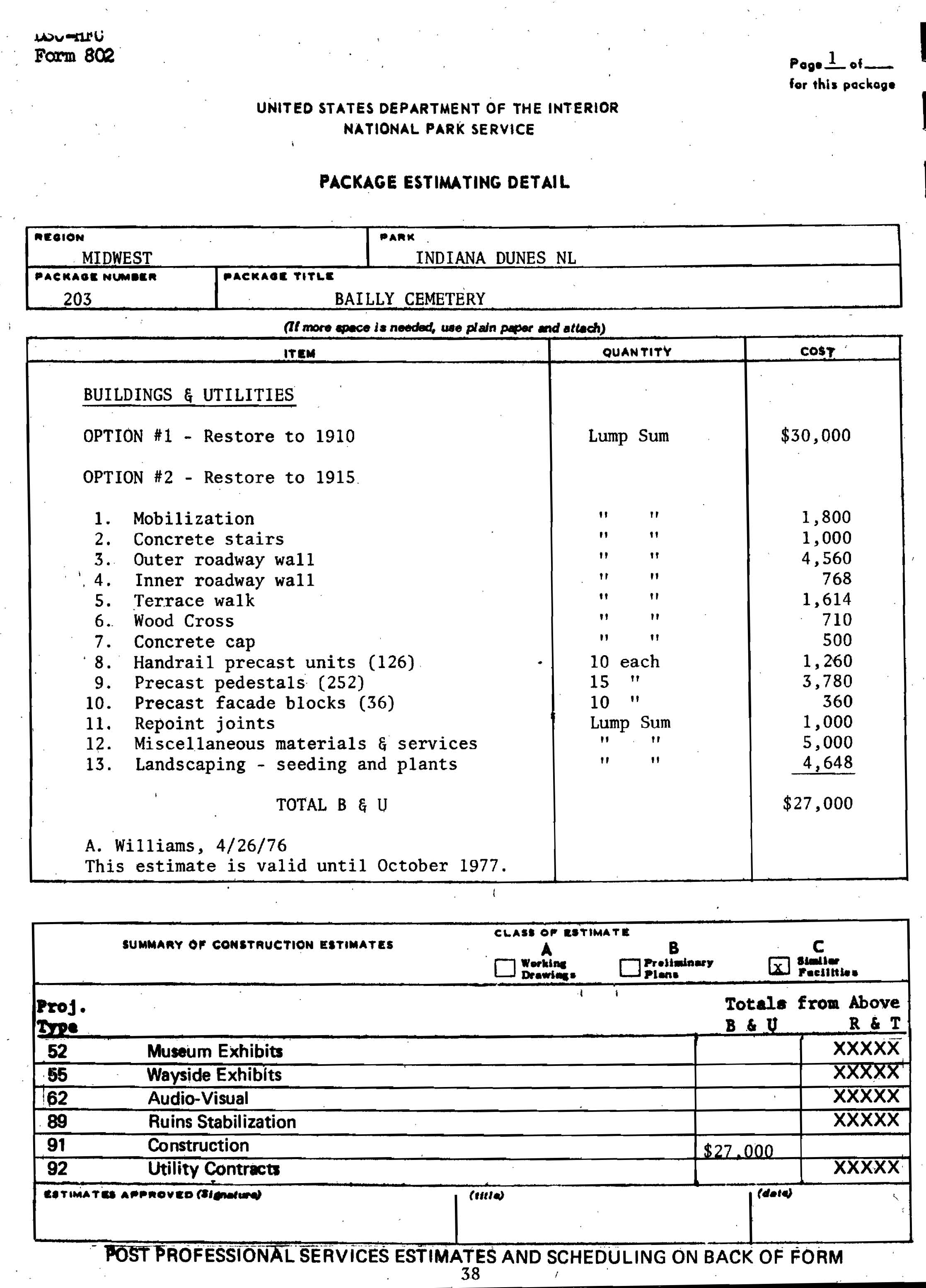
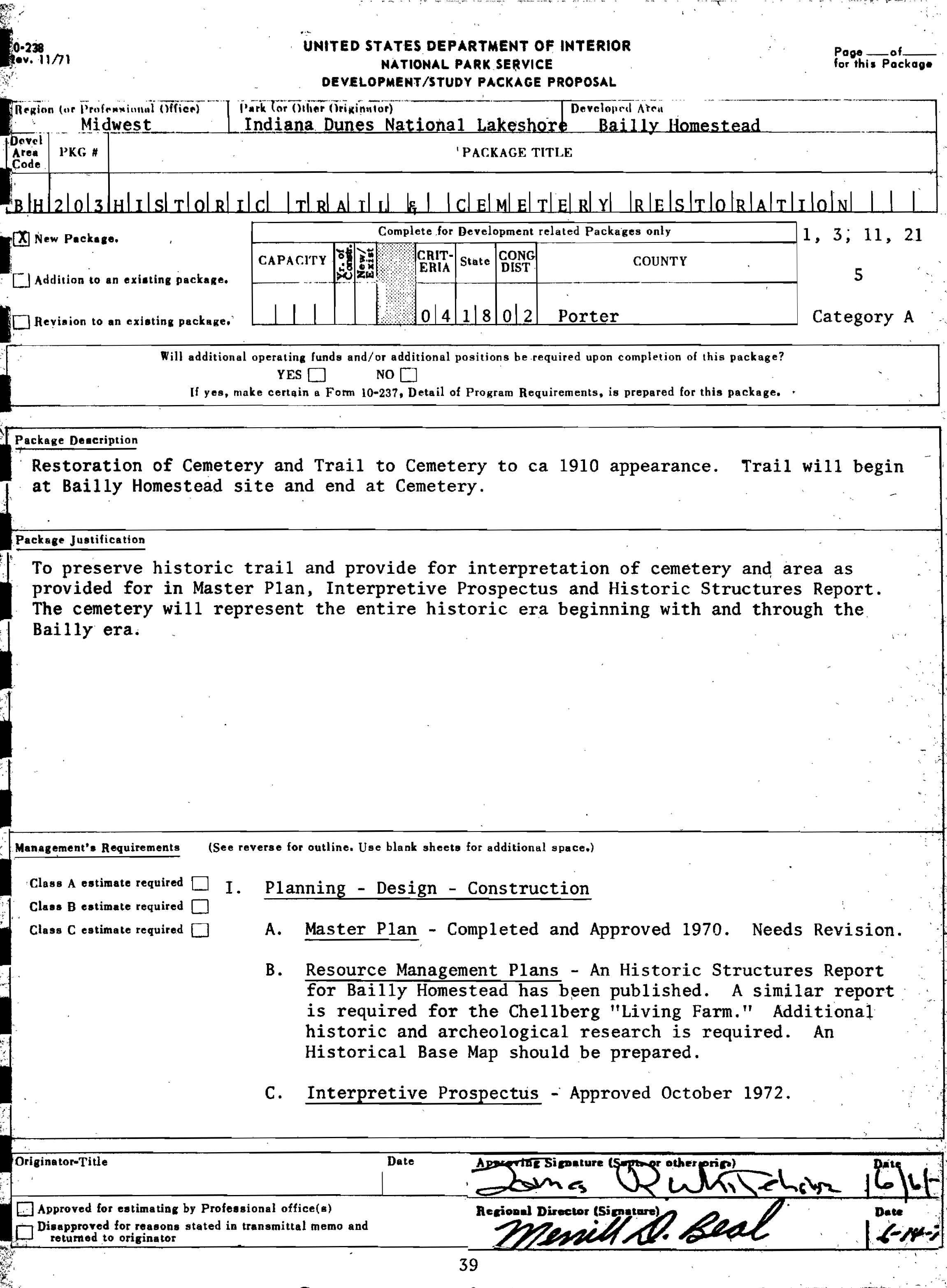
Package Description
Restoration of Cemetery and Trail to Cemetery to ca 1910 appearance. Trail will
begin at Bailly Homestead and end at Cemetery.
Package Justification
To preserve historic trail and provide for interpretation of cemetery and area
as provided for in Master Plan, Interpretative Prospectus and Historic
Structures Report. The cemetery will represent the entire historic era beginning
with and through the Bailly era.
Management's Requirements
I. Planning - Design - Construction
A. Master Plan - Completed and
Approved 1970. Needs Revision.
B. Resource Management Plans -
An Historic Structures Report for
Bailly
Homestead has been published. A similar report is required
for the
Chellberg "Living Farm." Additional historic and archeological
research is
required. An Historical Base Map should be prepared.
C. Interpretive Prospectus -
Approved October 1972.
40
D. Development Concept Plan -
626/40,009 approved 1973.
E. Buildings and Utilities
Required - Restoration of cemetery.
F. Roads &/or Trails Required
- .8 mile of historic trail
IV. History - Historic Structures Report completed 1972.
V. Museum Exhibits and Audiovisuals
C. Wayside Exhibits
Interpretive signing (6 signs)
VI. Archaeology (see following studies)
Honerkamp, Marjory
1968 An appraisal
of the Archeological Resources and Ecological
Context of the Proposed Indiana Dunes National Lakeshore,
Ms, Mational Park Service, Lincoln
Limp, Frederick
1964 An
Archeological Study of an Early Historic Homestead in
the Calumet, Ms, National Park Service, Lincoln
41
[Click to Enlarge]
42
Part I
Description
Package 203 provides for the restoration of the Historic Trail and Cemetery,
Bailly Homestead, Indiana Dunes National Lakeshore. It is recommended that the
cemetery be considered third order of significance. The level of treatment will
be restoration. A class B architectural investigation will be conducted to
determine recommendations for treatment. A Historic Structure Report will be
prepared including the following sections: Architectural Data Section, Historic
Data Section and Administrative Data Section. Funds for contract documents have
not been programmed.
Although the development/study package proposal for this package is titled
"Historic Trail and Cemetery Restoration" and the comprehensive design makes
reference to a historic trail, no physical evidence has been found to
substantiate the existence of such trail - either for walking or carriage. It is
recommended that "Historic Trail" be eliminated from the title of this project.
Because Bailly Homestead is listed on the National Register of Historic Places,
projects affecting it are subject to the requirements of the Advisory Council on
Historic Preservation "Procedures for the Protection of Historic and Cultural
Environment (36 CFR Part 800). Historic preservation concerns will be paramount
and at the appropriate stage of
43
planning, the Regional Director shall, in consultation with the Indiana State
Historic Preservation Officer, apply the Advisory Council "Criteria for Evvect
(Sec. 800.8) and "Criteria for Adverse Effect" (Sec. 800.9) and afford the
Advisory Council an opportunity to review and/or comment on the proposal.
Programmed Funds - Package No. 203
Project Type
Amount FY
Acct. No.
05 Survey
$10,000 76
0320-399*
*These funds are not needed at this time and should be
reprogrammed.
35 Historic Structure Report 12,000
76 1375-399
Future Programmed Funds
None
Estimated Work Schedule
Administrative Data Section, March 1976
Architectural Data Section, March 1976
Historical Data Section, March 1976
Archeological Data Section, March 1976
44
Team
Alan C. Reynolds, Historical Architect, DSC
Kenneth Bennett, Architecture Technician, DSC
Thomas Armstrong, Exhibits Specialist, DSC
A. H. Gustavson, Landscape Architect, DCS
Berle Clemensen, Historian, DSC
Deborah Bauxer, Archeologist, DSC
Superintendent, Indiana Dunes National Lakeshore, for preparation
of Administrative Data Section
Consultants
Superintendent and staff, Indiana Dunes National Lakeshore
Midwest Regional Office
Historic Preservation Division, DSC
Division of Design, DSC
Park Historic Preservation, WASO
Midwest Archeological Center
45
Part II
Scope of Work
I. Administrative Data
This section has already been prepared by the park staff and will be included in
the report.
II. Historical Data
To be prepared by DSC historian.
III. Architectural Data
A. Summary of historical data
B. Anticipating use of the cemetery
C. Evaluation of the present
conditions of the cemetery.
D. Causes of present deterioration.
E. Evaluation of methods and
materials for the cemetery rehabilitation
F. Landscape design
G. Additional design considerations
1. Re-activation of the well and windmill
2. Methods of providing security against vandalism
H. Project time schedules
I. Preliminary drawings for the
proposed restoration
J. Cost estimated for restoration
46
Part III
Basic Data
Historic Structure Report, Historical and Architectural Data on Bailly
Homestead, Indiana Dunes National Lakeshore, prepared by Harry Pfanz and
Russell Jones, November 1972.
Bailly Cemetery - Roman Style, by Theodore Stephens
Master Plan, Indiana Dunes National Lakeshore, approved Lemuel Garrison,
Director, Northeast Region, November 1969.
Interpretive Prospectus (a part of the Master Plan) approved Henry G.
Schmidt, Director, Northeast Region, February 1971.
Comprehensive Design Plan for Bailly Homestead Unit, recommended for
revision by Superintendent, September 1975.
47
BIBLIOGRAPHY
Carlson, E. H. "Reverend Carlson Attends and Writes about Funeral of Gifted
Daughter of Early Indiana Settler." Chesterton (Ind.) Tribune, February
7, 1918.
Nelson, C. W. "The Bailly Cemetery." (1949). MS, Reed Folder, in files of
Indiana Dunes National Lakeshore Park.
Pfanz, Harry W., and Jones, T. Russell. Historic Structure Report, Bailly
Homestead, Historic and Architectural Data, Indiana Dunes National Lakeshore,
Indiana. 1972. MS, in files of Historic Preservation Division, DSC, National
Park Service.
Stephens, Theodore. "Bailly Cemetery - Roman Style." Duneland Historical
Society, Living Biographies 2, no. 4 (May 1956).
48
[Blank page]
49
HISTORICAL PHOTOGRAPHS
50 and 51
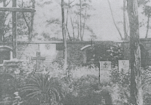
Plate 1.
This pre-1913 photograph is an interior view of the north wall, revealing the
necropolis's enclosed interior. Note the limestone wall with the attached wooden
cabinets and embedded granite plaques, which supports an iron-spiked concrete
cap.
Date and photographer unknown.
Negative from files,
Indiana Dunes National Lakeshore Park.
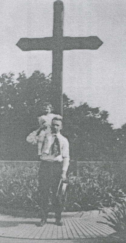
Plate 2.
The relatively large scale of the prominent cross may be seen when comparing it
to the persons dwarfed beneath it. Note the bolted cross straps that secure the
horizontal member to the vertical staff. Duplicate cross straps were used on the
opposite side of the cross.
Date and photographer unknown.
Negative from files,
Indiana Dunes National Lakeshore Park.
52 and 53
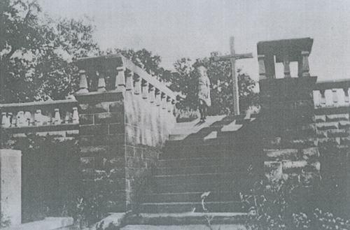
Plate 3.
A post-1915 photograph showing clearly the detail of the balustrade. The
stairway leads down from the sand-filled necropolis to the terraced roadway.
Date and photographer unknown.
Negative from files,
Indiana Dunes National Lakeshore Park.
54 and 55
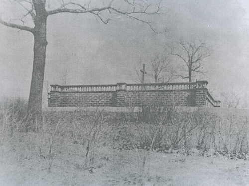
Plate 4.
A post-1915 photograph showing how the cemetery will appear after restorative
construction. West elevation shown.
Date and photographer unknown.
Negative from files,
Indiana Dunes National Lakeshore Park.
56
[blank page]
57
PHOTOGRAPHS OF EXISTING CONDITIONS
58 and 59
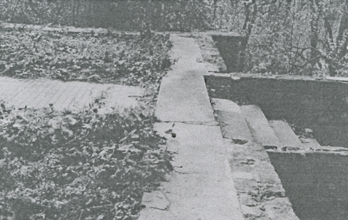
Plate 5.
Photograph indicates where the balustrade pedestals once stood in a staggered
alignment. Upper stairway tread shows evidence of weathering, although damage is
partially hidden by presence of leaves.
October 1975
DSC negative.
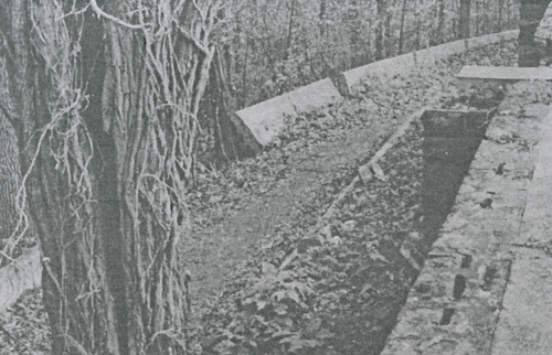
Plate 6.
This southern portion of the outer retaining wall is shown in a state of
collapse. Grade erosion on the downhill side is responsible for this occurrence
as are lateral grade forces exerted by the ascending terraces.
October 1975.
DSC negative.
60 and 61
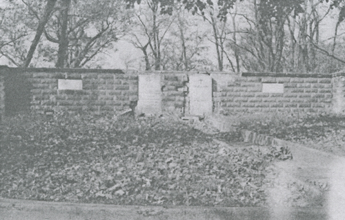
Plate 7.
Existing conditions of south elevation are shown in this photograph. Note the
areas of deterioration, which are primarily confined to the precast concrete
wall coping.
October 1975.
DSC negative.
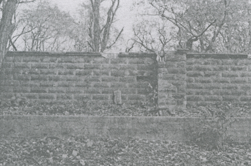
Plate 8.
Both the western cemetery wall and the corresponding inner belting retaining
wall are included in the photograph. Wall facade deterioration is most
noticeable at buttresses or in areas adjacent to them.
October 1975.
DSC negative.
62 and 63
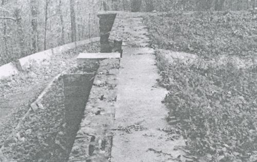
Plate 9.
A detail photograph of the existing wall coping's cellular configuration. These
cells allow water to penetrate the precast facade, thus making the wall highly
vulnerable to normal freeze-thaw cycles. Also pictured is one of the radiating
grooved walkways that show evidence of severe settling to the extent of
fracturing.
October 1975
DCS negative.
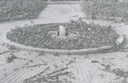
Plate 10.
Contained within the necropolis's centrally located walkway circle is the
cross's stone anchor insert and the encompassing footing. Piercing the limestone
anchor is a steel dowel used to attach the sleeved butt of the cross to the
stone anchor.
October 1975.
DSC negative.
64 and 65
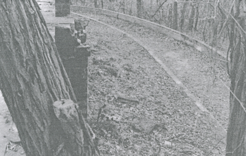
Plate 11.
Tree in foreground is presently crushing the wall's coping at the point of
contact. Since this is obviously a structural hazard, the tree limb must be
removed to preclude further damage.
October 1975.
DSC negative.
66
[blank page]
67
DRAWINGS
68
Sheets 1-5, #626/28,000
Bailly Cemetery: Existing and Proposed Conditions.
69
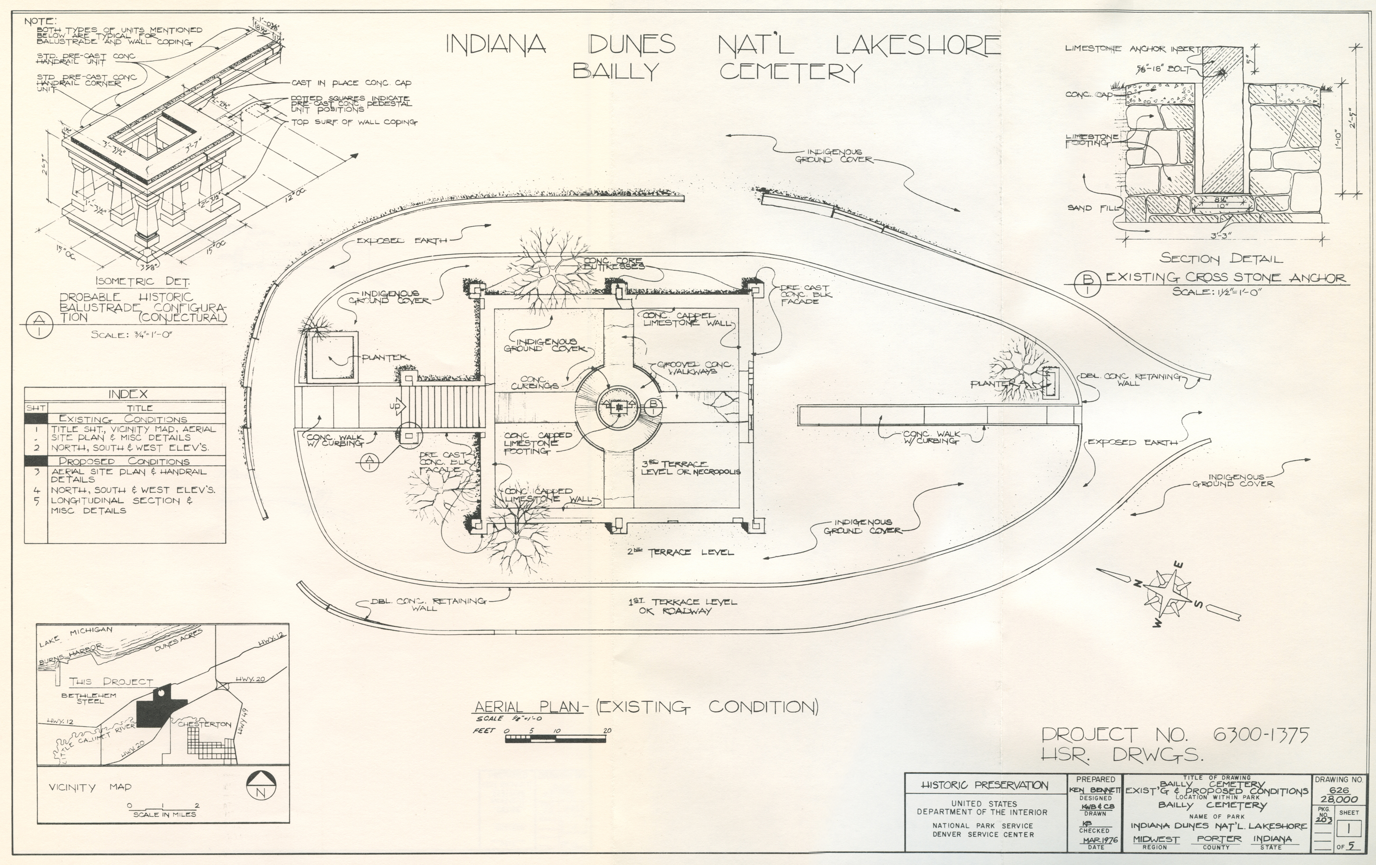
AERIAL PLAN - (EXISTING CONDITION)
[Click to Enlarge]
70
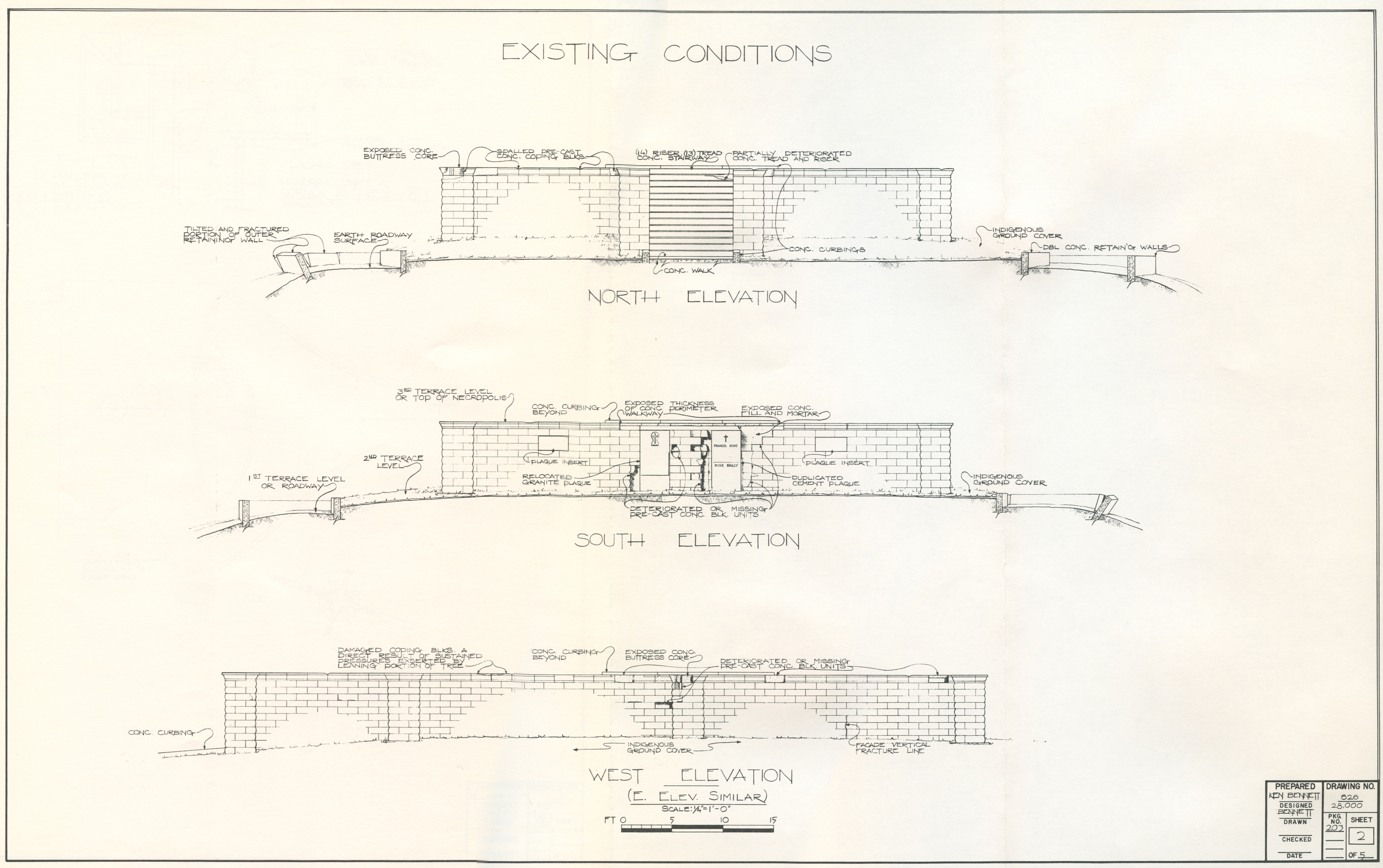
EXISTING CONDITIONS
NORTH ELEVATION
SOUTH ELEVATION
WEST ELEVATION
[Click to Enlarge]
71
AERIAL PLAN - (PROPOSED CONDITION)
[Click to Enlarge]
72
PROPOSED CONDITIONS
[Click to Enlarge]
73
LONGITUDINAL SECTION - (PROPOSED CONDITION)
[Click to Enlarge]
74
[blank page]
75
IV. ARCHEOLOGICAL DATA
by
Catherine H. Blee
76
A. Preliminary Information
At the request of Ken Bennett, Architecture Technician, Historic Preservation
Division, DSC, this writer monitored his exploratory diggings at Bailly
Cemetery, Indiana Dunes National Lakeshore. The work took eight hours on March
2, 1976, and about four hours on March 3. It was done as a part of the historic
structure report being prepared by Ken and Berle Clemensen, Historian, DSC-MH.
Six man-days were used in preparation for the trip (i.e., records search and
library research), three man days in the field, and five man days in preparation
of the report.
B. Description and Exploratory Work
Beginning at an area about three feet south of the northeast buttress of the
cemetery and proceeding four to six feet south, the lower portion of the
concrete block facing of the cemetery wall had fallen away. Mr. Bennett was
concerned that settling of the wall had caused structural damage in that area,
and that the footing under the wall were damaged to the extent that they would
have to be repaired or replaced. This was the major area of investigation.
After some brief exploratory work in an area designated Test Pit A (See Fig. 1),
the writer staked out a test trench (A) measuring forty-five inches east from
the exposed limestone wall and fifty inches wide. The concrete rubble that had
fallen from the wall was removed from the ground surface. The footing was
encountered one to two inches below the surface. The trench was taken down in
natural levels; that is, each level was of relatively homogeneous material.
The exposed profile (Fig. 2) clearly showed the development activity at the
cemetery. Level 1 is mainly topsoil and humic material, heavily interlaced with
root systems. Level 2 is mixed sand and humus; its mottled appearance implied
that it was fill. The contractor, Mr. Stephens, apparently covered the footing
with the mixed dirt and sand from the trenches excavated for the footing. Level
3 substantiates this idea; there is a two- to three-inch dark-brown humic layer
that rapidly grades into light-colored sand at the top of the level. This was
the original surface of the stabilized dune on which the cemetery sits. Level 4
consists of fine, sterile yellow sand, almost exclusive of any other material. A
few worn stones, a chipping flake, and two objects that shall be discussed later
were encountered. The trench was taken down to just below the footing in order
to get an accurate measurement.
The wall footing was found to be complete and in excellent shape. The eroding of
the wall was undoubtedly caused by water seepage and by root systems seeking the
water retained in the cells of the concrete facing. There should be no
structural damage to the footing of the cemetery wall.
Level 4, being sterile, homogeneous sand, represents the original living dune.
The prehistoric material that it contained is not diagnostic; material on a
living dune may not have been deposited in situ. The flake is man-made;
77
BAILLY CEMETERY
PLAN: TRENCH A - EAST WALL
3/2/1976
[Click to Enlarge]
78
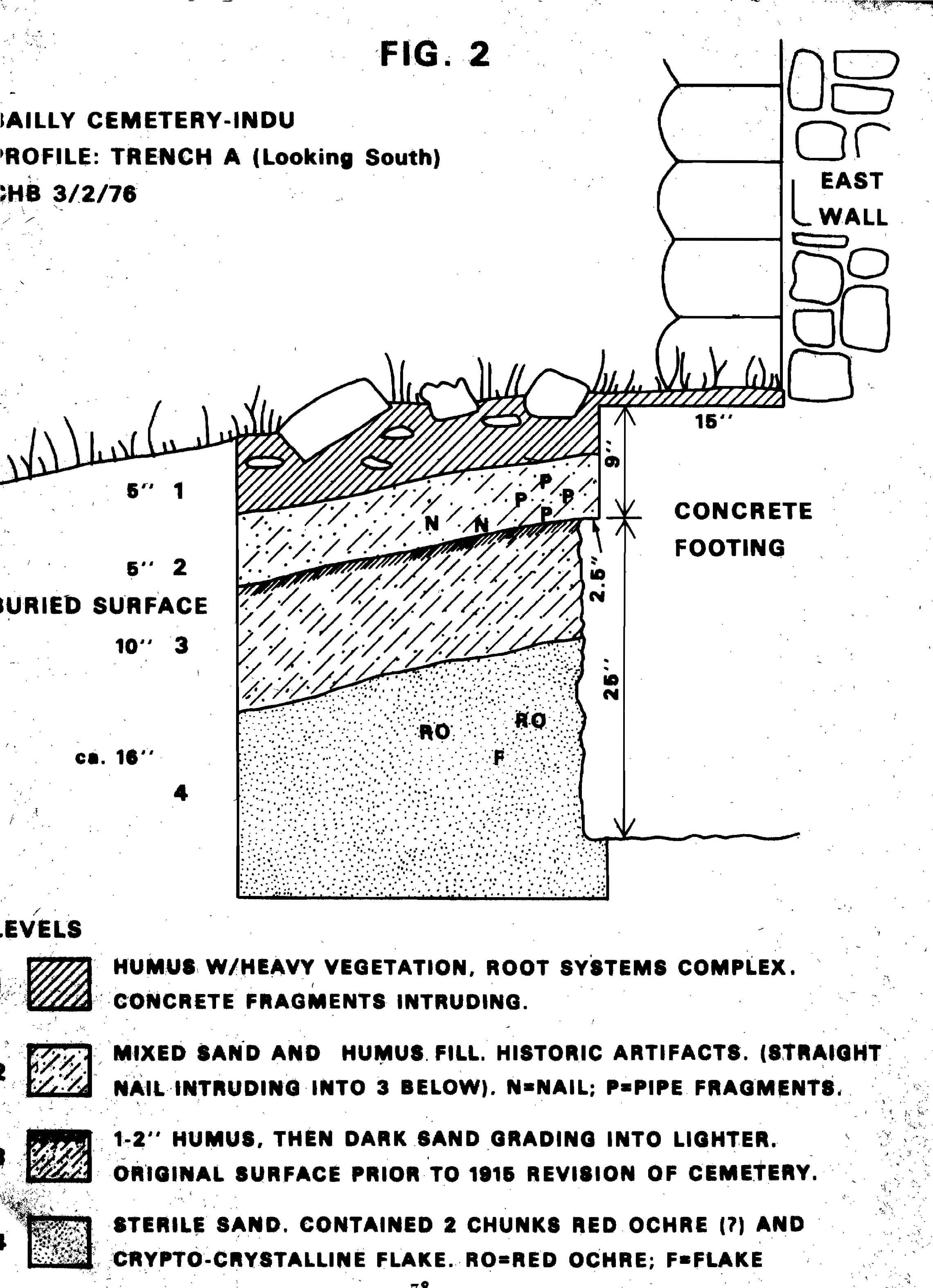
BAILLY CEMETERY
PLAN: TRENCH A (Looking South)
3/2/1976
[Click to Enlarge]
79
two chunks of red, granular rock were observed to be sand grains held together
with hematite. These rocks could have been formed in the dune by pockets of
standing water holding iron, or have been brought in for use by the Indians (Hagood,
personal communication). Ground against a hard surface, the material crumbles
and could be used as red pigment. Either way, the evidence provided by the
hematite and the flake is inconclusive.
Level 4's indication of some sort of prehistoric activity tends to substantiate
local feeling that the Bailly Cemetery was used aboriginally. Neil King, park
interpreter, told me that the cemetery is often called "the Indian Cemetery,"
but could not cite any evidence substantiating this claim. McAllister (1932)
mentions an "Indian Burial Ground" in his survey of Porter County, but placed it
in the NE 1/4 of the NE 1/4 of the NW 1/4 of Section 26, Township 37 North,
Range 6 West. The Bailly Cemetery is in the NE 1/4 of Section 27, placing the
two no more than one-half mile apart. There is a possibility that the two
cemeteries were confused with each other.
At the time that Theodore Stephens rebuilt the cemetery, ca. 1915, he
encountered human bones in his construction activities, but he stated they were
"the graves of people of the community" (Stephens, n.d.:3).
Nelson, in an early report on the cemetery, commented on its Indian origins:
The cemetery has variously been
referred to as the Bailly
Cemetery, the Catholic Cemetery and
the Indian Cemetery.
These terms are probably all correct.
It is quite well
authenticated that the Indians used
the sand ridge along
the ancient shore-line for their
burials. The Bailly hill
being the largest dune of the ridge
was probably used more
than the smaller hills to the east
and west (Nelson, n.d.:2).
He does not give his source for the "quite well authenticated" fact, and may
have perpetuated a myth. Unless more prehistoric material is recovered under
strict scientific control, nothing can be assumed. However, these "rumors" and
the flake recovered are reason enough to recommend continued surveillance during
any and all ground disturbance involved in restoring the cemetery.
A good overview of the prehistory of the Bailly Homestead area is given by Limp
(1974:5-10), and should be consulted during any further archeological work at
the cemetery. Porter County experienced the full gamut of prehistoric occupation
in the northeast, from Paleo-Indian through the Archaic (including an
interesting overlap of the Red Ochre, Old Copper, and Glacial Kame complexes),
and into the Woodland. Historic tribes include the Potawatomi, Wea, and Miami.
The late Archaic complexes mentioned above are defined by their burial customs,
so there is good material available. The Woodland burial customs are also well
documented; they usually involved artificial mounds. I could find no reference
to burial customs of the historical tribes in the area. Since McAllister (1932),
in his description of the "Indian Burial Ground" in Section 26, did not give the
particulars of the interment, it is impossible
80
to determine what culture it may be associated with. No probable association for
possible prehistoric graves at Bailly Cemetery can be made at this time.
Two other exploratory diggings were undertaken, neither of which disturbed
cultural material. Test Pit B, plotted in on Fig. 3, was dug to determine what
Stephens had used to fill in the original south gate in the limestone wall. The
test pit was about eight inches deep and measured eighteen by sixty-six inches.
The soil consisted of mixed sand and humus capped by a four-inch-thick topsoil
brought in to fill the inner part of the cemetery. The testing showed that he
filled the gap with rough-cut limestone, barely mortared.
The third area of investigation was at an eight-foot gap in the outer retaining
wall along the east side of the cemetery. With a trowel point, the writer
encountered a hard substance about three inches below the surface. In tracing
this resistance, an eight-inch-wide concrete footing that ran the length of the
gap was exposed. Only the three- to four-inch humic layer above the footing was
moved; no cultural material was found.
Trench A was backfilled above the top of the footings, and some scattered
concrete blocks replaced on the surface to prevent erosion. Test Pit B was
filled with its back dirt and was small enough that spring vegetation will
obliterate any sign of the testing. The retaining wall footings were left
exposed.
81

BAILLY CEMETERY
PLAN: TEST PIT B
3/3/1976
[Click to Enlarge]
82
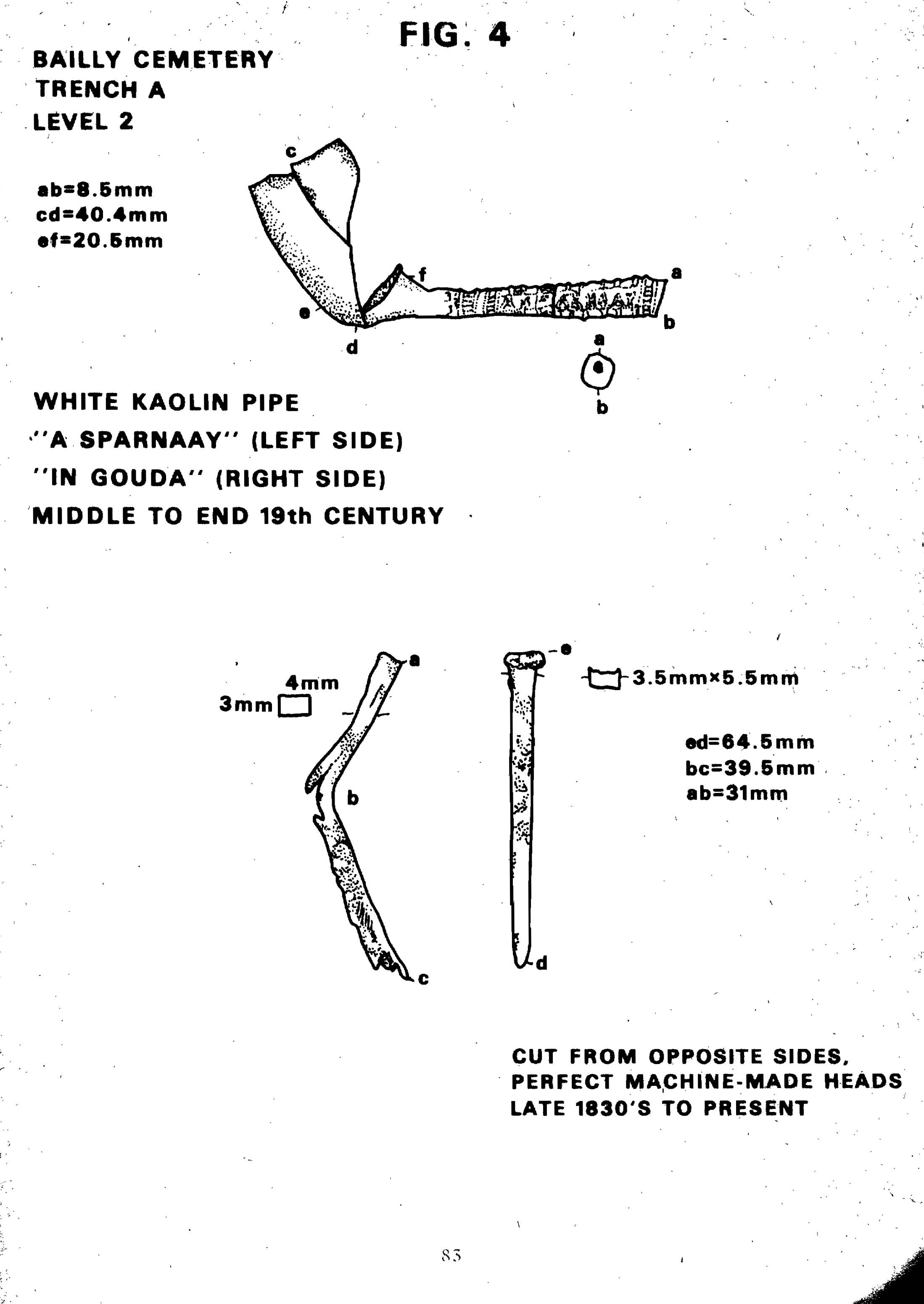
APPENDIX
Artifacts from Test Trench A
Level 2, of Test Trench A yielded three artifacts of some note: a fragmented
pipe and two square nails. Drawings of the artifacts are seen in Fig. 4.
Nails:
Two square nails were found in Level 2, which appears to be fill, and probably
came from the trench dug for the footings. Both nails have shanks that are
rectangular in cross section; they taper in towards the end on two sides but are
parallel on the other two, indicating that they are machine cut. The one
complete nail is burred on the same side, which indicates that it was made by
the "flipping" technique. The shank goes straight up to a machine-made head, and
the metal fiber runs the length of the nail rather than crosswise as shown in
the bent nail. All of these characteristics indicate that the nails could not be
older than 1830, providing Level 2 with a terminus ante quem date of 1830
(Nelson, 1968; Noel Hume, 1974).
Pipe:
Level 2 also yielded four fragments of a white kaolin pipe, which, when cleaned,
fit together to form the groken pipe pictured in Fig. 4. Ivor Noel Hume talks
about the importance of the clay pipe in dating historical sites:
The English kaolin tobacco pipe is
possibly the most valuable
clue yet available to the student of
historical sites, for it
is an item that was manufactured,
imported, smoke, and thrown
away, all within a matter of a year
or two. . . . In addition,
pipes were extremely cheap (selling
in 1790 for as little as
two shillings a gross), thus making
them available to all
economic levels of colonial society.
They were as expendable
as cigarettes, though vastly more
durable, ensuring that their
fragments survive in the ground in
prodigious quantities
(Noel Hume, 1974:296).
The kaolin pipe had completely fallen out of popularity by the turn of the
century, thus indicating that Level 2 came from below the top of Level 3
originally. This buried surface dates at 1915 because it corresponds to the
bottom of the molded footing and would have been the original surface.
The Bailly Cemetery pipe has an undecorated bowl and a relief-decorated stem
bearing the words "IN GOUDA" in the right side and "A SPARNAAY" on the left,
indicating it was made by a company called A. Sparnaay in Gouda, Holland, and is
of a middle- to late-nineteenth-century date (Hanson, 1971:98, and Humphrey,
1969:18-20).
83
BAILLY CEMETERY
TRENCH A
LEVEL 2
[Click to Enlarge]
84
BIBLIOGRAPHY
The Cemetery
Clemensen, Berle
1975 Bailly homestead unit, Indiana Dunes National Lakeshore:
history,
maps,
evaluation of historic resources, determinations of structures
composing the
Bailly homestead. Historic Preservation Division,
National Park
Service, Denver Service Center. xeroxed.
Howe, France R.
1907 The story of a French homestead in the Old Northwest.
Press of
Nitschke
Bros., Columbus, Ohio.
Nelson, C. W.
1949 The Bailly cemetery. Reed Folder. Indiana Dunes National
Lake-
shore Park.
xeroxed.
Pfanz, Harry W., and Jones, T. Russell
1972 Historic structure report, Bailly homestead, historical
and
architectural
data, Indiana Dunes National Lakeshore, Indiana.
Historic
Preservation Division, National Park Service, Denver
Service
Center. xeroxed.
Stephens, Theodore
1956
Bailly cemetery--Roman style. Duneland Historical
Society, Living
Biographies 2, no. 4.
The Prehistory
Dorwin, John T.
1966 Fluted points and late Pleistocene geochronology in
Indiana. The
Prehistory
Research Series of the Indiana Historical Society 4,
no. 3.
Fitting, James E.
1970 The archaeology of Michigan: a guide to the prehistory
of the Great
Lakes
region. Natural History Press, Garden City, New York.
Honerkamp, Marjory
1968 An appraisal of the archaeological resources and
ecological context
of the
proposed Indiana Dunes National Lakeshore. Manuscript report.
Historic
Preservation Division, National Park Service, Denver
Service
Center.
Limp, W. Frederick
1974 The Bailly site: an archaeological study of an early
historic
homestead in
the Calumet. Manuscript report. Historic Preservation
Division,
National Park Service, Denver Service Center.
85
McAllister, J. Gilbert
1932 The archaeology of Porter County. Indiana History
Bulletin 10,
no. 1.
Morgan, Richard G.
1952 Outline of cultures in the Ohio region. In The
Archaeology of the
Eastern
United States, edited by James B. Griffen. University of
Chicago
Press.
Oswalt, Wendell H.
1973 The fox. In This land was theirs, a study of the North
American
Indian.
John Wiley and Sons, New Yok.
Quimby, George I.
1952 The archaeology of the Upper Great Lakes area. In The
archaeology
of the
Eastern United States, edited by James B. Griffen. Univer-
sity of
Chicago Press.
Ritzenthaler, Robert E., and Quimby, George I.
1962 The Red Ochre culture of the Upper Lakes and adjacent
areas.
Fieldiana.
Anthropology 36, no. 11:243-275.
The Artifacts
Hagood, Allen
(Personal
communication. Geologist, Pacific Northwest/Western
Planning
Team, Denver Service Center, National Park Service.)
Hanson, Lee H. Jr.
1971 Pipes from Rome New York. Historical Archaeology
5:92-99.
Humphrey, Richard V.
1969 Clay pipes from old Sacramento. Historical Archaeology
3:12-33.
Nelson, Lee H.
1968 Nail chronology as an aid to dating old buildings.
American
Association
for State and Local History Technical Leaflet 48,
History
News 24, no. 11.
Noel Hume, Ivor
1974 A guide to artifacts of colonial America. Alfred
A. Knopf, New
York.
Wilson Rex L.
1971 Clay tobacco pipes from Fort Laramie National Historic
Site and
related
locations. National Park Service.
As the Nation's principal conservation agency, the Department of the Interior
has basic responsibilities to protect and conserve our land an water, energy and
minerals, fish and wildlife, parks and recreation areas, and to ensure the wise
use of all these resources. The Department also has major responsibility for
American Indian reservation communities and for people who live in island
territories under U. S. administration.
NPS 1125
FOOTNOTES:
Part II. Historical Data
1. C. W. Nelson, "The Bailly Cemetery," (1949), MS, Reed Folder, in files of
Indiana Dunes National Lakeshore Park, pp. 4-7.
2. Ibid., p. 3.
3. Chesterton (Ind.) Tribune, September 9, 1909; Nelson, "The Bailly
Cemetery," p. 3.
4. Frances R. Howe, The Story of a French Homestead in the Old Northwest
(Columbus, Ohio: Press of Nitschke Bros., 1907), p. 68.
5. Nelson, "The Bailly Cemetery," p. 3; Olga Schiemann, "Historical Notes,"
(1952), MS, in files of Indiana Dunes National Lakeshore Park, p. 3.
6. Schiemann, "Historical Notes," p. 3. Mrs. Rose Bailly Howe paid her
brother-in-law, Joel Wicker, twenty-five dollars to fence the area.
7. Nelson, "The Bailly Cemetery," p. 7.
8. Schiemann, "Historical Notes," p. 4.
9. Theodore Stephens, "Bailly Cemetery--Roman Style," Duneland Historical
Society, Living Biographies 2, no. 4 (May 1956): 1-2. "The Bailly Cemetery,"
pp. 6-7, 9.
10. Chesterton (Ind.) Tribune, December 3, 1884.
11. Stephens described the plaques and cross in "Bailly Cemetery--Roman Style."
12. Nelson, "The Bailly Cemetery," p. 6; Stephens, "Bailly Cemetery--Roman
Style," p. 2.
13. Stevens, "Bailly Cemetery--Roman Style," p. 2.
14. Ibid., pp. 2-3.
15. Ibid., pp. 3-4.
16. Ibid., p. 2.
17. Chesterton (Ind.) Tribune, February 7, 1918; Stephens, "Bailly
Cemetery--Roman Style," p. 3; Nelson, The Bailly Cemetery," p. 11.
18. Chesterton (Ind.) Tribune, February 7, 1918; Nelson, "The Bailly
Cemetery," p. 11.
19. Nelson, "The Bailly Cemetery," pp. 11-12.
Part III. Architectural Data
1. A cemetery, especially one of large size or of olden times.
2. Theodore Stephens, "Bailly Cemetery--Roman Style," Duneland Historical
Society, Living Biographies 2, no. 4 (May 1956): 2.
3. C. W. Nelson, "The Bailly Cemetery," (1949), MS, in files of Indiana Dunes
National Lakeshore Park, p. 5.
4. Nelson, "The Bailly Cemetery," p. 9.
Bailly Homestead historical transcriptions prepared by Steven R. Shook