Native American Burial GroundsIndex of Native American Burial Grounds in Porter County . . . .
Numerous Native American burial grounds have been identified in Porter County.
The burial customs of Native Americans have varied widely, not only geographically,
but also through time. Differing environments, social structure, and spiritual
beliefs led to various burial practices. In the region surrounding and including
Porter County, the common Native American burial practice included the construction of earthen
mounds, some of which were chambered mounds and others that were crematory
mounds. Several prominent Native American burial mounds once existed in Porter
County; it has been reported that a total of at least 42 Native American mounds
existed at one time in Porter County. Most of these mounds have been leveled due to farming practices, development, and
destruction from early archaeological digs and curiosity seekers.
Below is an enumeration, listed alphabetically by township, of known Native American burial
grounds located within the boundaries Porter County. It should be noted that not
all mounds were constructed and used by Native Americans as burial tombs. For
instance, piles of earth were heaped into mounds for the purpose of elevating
wigwams in low, wet areas. As such, we do not provide a list of all known
mounds, both existing and obliterated, in the county. Rather, we review only
those Native American mounds that are known to have yielded human skeletal
remains upon excavation.
Boone Township
A. In a history of Boone Township published
in 1936 in The Vidette-Messenger, it is reported that:
"Even today it is not uncommon to
find arrow heads and stone
hatchets in Boone Township.
Immediately across what is now
State Road No. 152 from Hod Morrow's
house near the Kankakee
is an old Indian burial ground. J. M.
Morrow recalls that together
with his brother Hod and other boys
of the community he has
unearthed many arrow heads, hatchets
and bones. He has a
collection of these early relics.
Some of the skeletons had been
buried in a horizontal position,
others in a sitting position. One
tiny grave was uncovered and was
encased on clam shells but
containing no bones. This undoubtedly
was the grave of an infant
whose bones were not as yet ossified.
It was not an uncommon
practice for infants to be buried in
hollow logs. We can well imagine
that over these burial mounds the
Indian squaws blacked their
faces and cooked and ate their food
as was their custom in
mourning their departed. It is small
wonder when they revisited
these mounds, after they have moved
westward, that they were
shocked by the fate of the sacred
burial places. In a visit to the
burial ground just mentioned the
writer in company with M. E.
Dinsmoore found, in a matter of a few
minutes, three arrow
heads, a part of an Indian axe and
several human bones. A corn
field now covers the mound."
The aforementioned burial ground is referred to in McAllister's report on the
archaeology of Porter County as Site 32. McAllister places the exact location
of this Native American burial site at the northwest quarter of the southwest
quarter of the southwest quarter of Section 26, Township 33 North, Range 7 West.
As of 2012, the site is under cultivation for agricultural purposes. With regard
to this burial site, McAllister states that:
"...the Morrow family has come
upon burials in the sandy elevation,
twenty rods east of the highway. A
pipe is said to have been found
with one burial. It is also reported
by U. H. Morrow that mussel
shells were placed with the burial,
usually over the body. This was
noted a number of times in burials
found in several places on the
sandy elevation. The site is now
planted in corn."
B. A Native American burial ground is located upon a sandy ridge in the
northeast quarter of the northeast quarter of Section 27, Township 33 North,
Range 7 West, which is the land located directly southwest of the intersection of Indiana State
Route 2 and US Route 231. McAllister's report on the archaeology of Porter
County refers to this Native American burial site as Site 32, and states that:
"This is known generally
throughout the region as an Indian
burial ground."
Today, this land contains several residential homes.
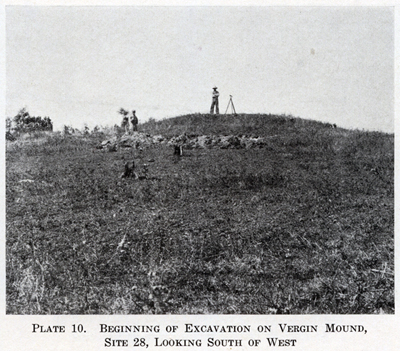
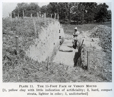
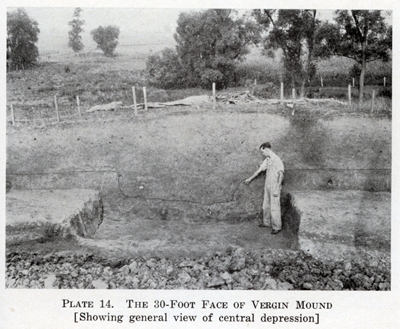
C. The Vergin Mound was a rather isolated and undisturbed mound until
1932 when J. Gilbert McAllister and his archaeological team excavated the site.
The mound is named after Richard and Doshia Vergin, owners of the property on
which the mound is located at the time of its scientific excavation. The mound's
exact location is the southeast quarter of the northeast quarter of the
southwest quarter of Section 5, Township 33 North, Range 6 West. The 50 foot
diameter mound rose 4.5 feet above the surrounding elevations. Portions of five
different skeletons were uncovered during excavation.
D. The Aylesworth Mound is named after the Aylesworth family since it was
located on their property when the mound was first scientifically evaluated. The
mound is located in the northwest quarter of the southeast quarter of the
southeast quarter of Section 9, Township 33 North, Range 6 West, approximately
1,300 feet north of Indiana State Road 8 and 1,000 feet west of County Road 200
West. Today, the cul-de-sacs of Walter Drive and Chester Drive are located very
near the location of the Aylesworth Mound. The mound was excavated as early as
1891 by George C. Gregg, of Hebron, who found skeletal material at a depth of
three feet. No artifacts were found with the human remains.
E. In McAllister's archaeological report of Porter County is mentioned a
burial ground on the property of John Reif. The location of the burial ground is
the northwest quarter of the northeast quarter of the northwest quarter of
Section 17, Township 33 North, Range 5 West. Today, the burial site is situated
between Indiana State Road 8 and Reif Drive, within a subdivision of homes.
McAllister states that:
"Tradition among the oldest
settlers tells of a natural sand mound
which has been used as an Indian
cemetery. According to John
Reif white men are buried on the
southern slope of this same
elevation. Artifacts are sometimes
unearthed while plowing....About
100 feet north and on the line
between Sections 17 and 8, skeletons
and accompanying artifacts were
unearthed when a cut was put
through the sand ridge in building
the highway."
F. In Lewis Publishing Company's 1912 published history of Porter County
a large Native American burial ground is mentioned to exist in Section 21,
Township 33 North, Range 6 West:
"In the early '50s
[1850s] a sawmill was set up near the mouth of Sandy
Hook creek in Boone township, and
soon after that it was started a
number of old Indians visited the
neighborhood to pay their respects to
the graves of some of their
ancestors. This led to the discovery of an
old Indian burying ground some seven
or eight acres in extent, located
in section 21, township 33 north,
range 6 west, a short distance north of
the Kankakee river. After the
departure of the Indian visitors, excavations
were made and a number of implements,
weapons, ornaments, images,
etc., were found."
Source Citations:
Anonymous. August 18, 1936. "The Hebron School History of Boone
Township: As Compiled by History
Class and Instructors for
The Vidette-Messenger,"
The Vidette-Messenger Volume 10,
Section 3, pp. 21-23.
Blatchley,
W. S. 1898. "The Geology of Lake and Porter Counties, Indiana,"
(pp. 25-104) In: Indiana Department of Geology and Natural
Resources, 22nd Annual Report. Indianapolis, Indiana: William B.
Buford.
1,197 p. [see pp. 86-88]
Lewis Publishing Company. 1912. History of Porter County, Indiana: A
Narrative of its Historical Progress, its People and its Principal
Interests.
Volume I. Chicago, Illinois: Lewis Publishing Company.
357 p. [see p. 24]
McAllister, J. Gilbert. 1932. The Archaeology of Porter County. Indiana
History Bulletin 10(1):1-96.
Center Township
A. A brief mention on a Native American
burial ground located in Center Township is made in an August 27, 1960, column
concerning John Jacob Astor trading posts published in The Vidette-Messenger,
as follows:
".... No records exist, but Mrs.
Elizabeth Massey, who was an early
settler, often told of counting 45
Indian graves on the highland, close
to the site where our citizens
established the Old Cemetery, the
Union Street cemetery. That general
area was the only spot in the
vicinity high enough to permit a dry
grave to be dig."
Source Citation:
The Stroller. August 27, 1960. "Astor Trading Post Once Set Up In
This Community,"
The Vidette-Messenger Volume 34, Number 48,
Page 1, Columns 5 and 6, and Page 10,
Columns 5 and 6.
Liberty Township
A. A Native American burial ground reportedly existed
adjacent to the The Cole Cemetery. The Cole Cemetery, which no longer exists, was located on the southwest
quarter of Section 19, west of the Old 49 Highway. The cemetery was situated on
a hill just behind the Cole family farm, now occupied by the Liberty Bible
Church. After the death of Sally (Dillingham) Cole, the Cole farm was sold and
then resold to I. M. Biggs around 1900.
The Biggs family requested that the graves be moved from the site, which the
Cole family agreed to do since they feared that the tombstones would be removed
and the graves plowed over and obliterated. The graves and tombstones of four
Cole family members buried in the cemetery were disinterred and moved to the
Adams Cemetery in Morgan Township, where Sally (Dillingham) Cole's son had a
family plot.
B.
It has been reported that a probable Native American burial mound exists in the
northeast quarter of Section 25 of Liberty Township, adjacent to Liberty Farms
Mobile Home Park.
C. An Indian burial mound located near Gossett Cemetery was mentioned in
a article concerning Porter County published in The Vidette-Messenger in
1959. The article states, in part:
"At Gosset cemetery on Salt Creek is buried another
Revolutionary
War veteran, Father Bataan, who with his daughter came to the
ill-fated
City West to buy a town lot in 1837 -- and finding the
townsite a failure,
he took up his residence at Valparaiso. This old cemetery
dates so far
back in history that no one knows when the first white man
was buried
there. Nearby was an ancient Indian graveyard."
D. A possible Indian burial site was uncovered when a skull was found at
9:45 am on January 20, 2014, by Precision Pipeline LLC while excavating along
the route of the Enbridge Pipeline. The skull was located approximately 500 feet
west of Meridian road and one-quarter mile south of US Route 6 (east half of the
southeast quarter of Section 23). Preliminary research determined the skull was
of pre-1940 origin.
E. An Indian burial mound is reportedly located near Butternut Springs in
the east half of the southeast quarter of Section 27 of Liberty Township. A
lengthy description of Butternut Springs was written in 1936 by the Writers'
Program of the Works Progress Administration, which includes the following
statement:
"Although there are several springs in this vicinity none
is similar to
the one where the Indians brought their sick to be healed....
Two blocks west of the spring is a small mound which is
said to be
the grave of an Indian Cheif [sic]. At one end of the
grave is a tree
which has a crook in it which appears to look like the hump
on a
Camel's back and it is called the 'Camel Tree' for that
reason."
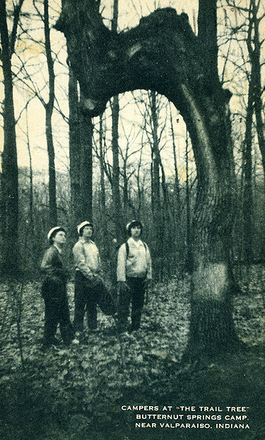
Postcard image of "Camel Tree" located at site of reported Native
American burial mound at Butternut Springs, Liberty Township, Porter
County, Indiana.
Source Citations:
Anonymous. December 22, 1971. "Does Ecology Play Part?"
The
Vidette-Messenger Volume 45, Number
144, Page 1,
Columns 3 and 4.
Communication with J. Timothy Cole of Chesterton, Indiana.
Scheibel, John. January 21, 2014. "DNR
Takes Over Investigation
of Skull Found in Porter County," The Times. [Accessed
June 28, 2015]
The Stroller. January 21, 1959. "Cemeteries Remind of Yesteryear,"
The Vidette-Messenger Volume 32, Number 67, Page 1,
Column 1, and Page 6,
Column 3.
The Stroller. September 15, 1961. "Liberty Township Neutral Zone
for Early Warriors,"
The Vidette-Messenger Volume 35, Number 62,
Page 1, Columns 7 and 8, and Page 8,
Columns 4 and 5.
Writers' Program, Works Progress Administration. 1936. Porter County,
Indiana, Folder 146. Terre Haute,
Indiana: Indiana State
University, Cunningham Memorial
Library. pp. 294-296.
Morgan Township
A. The LaCount Mounds are located in the
southeast
quarter of the northwest quarter of the southwest quarter of Section 30,
Township 34 North, Range 5 West in Morgan Township, approximately 400 feet north
of Sandy Hook Creek. The name of the mounds originates from the owner of the land
on which they were located, Charles F. LaCount. The mounds are reported to have been
approximately 15 feet in height, but by 1932 the height of the largest mound had
diminished to two feet due to previous excavations. Today, the mounds are virtually
flattened. Just west of the center of the largest mound, at a depth of three to four feet,
were found three skeletons. A leather-wrapped copper celt measuring 5.63 inches
in length, a pipe, and a piece of pottery were found with the skeletal remains.
An article published in the August 29, 1921, issue of
the Valparaiso Daily Vidette states that:
"An Indian mound, on the Charles LaCount farm, in Morgan
township, which has been
excavated by the LaCount Brothers,
has given up four skeletons of what are
generally believed
to be Indians. The bones of the bodies crumble upon being
exposed to the air, but the teeth are remarkably well preserved.
The skeletons
are those of big men, and tomahawks, pipes
and pottery found near the bodies
prove beyond a doubt that
they are Indians. The state of the bones indicates
that burial
took place many years ago. The mound itself, is twenty feet
high and
more than fifty feet across. The earth composing the
mound is clay texture of
soil that is proof against weathering.
There are three other mounds on the LaCount farm and these
will be excavated by the LaCount boys."
In 1921, Charles F. LaCount owned the majority of the south one-half of Section
30 in Morgan Township.
Source Citation:
McAllister, J. Gilbert. 1932. The Archaeology of Porter County. Indiana
History Bulletin 10(1):1-96.
Pleasant Township
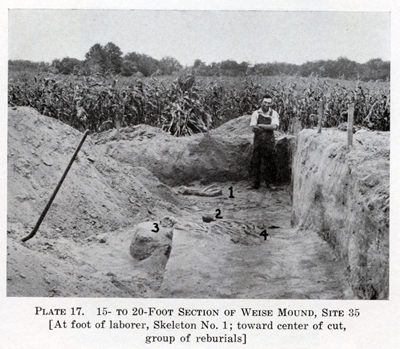
A. The Weise Mound is discussed in great
detail in McAllister's report of the archaeology of Porter County. The mound
was named after Albert Weise, on whose property the mound existed when it was
scientifically examined by McAllister. The exact location of the mound is the
northeast quarter of the southeast quarter of the northeast quarter of Section
27, Township 33 North, Range 6 West. Alternatively, the land located directly
southwest of where County Road 1025 South and County Road 100 West meet is where
the Weise Mound is located. Note that the region around the Weiss Mound was
commonly referred to as Indian Garden.
McAllister reports that the Weise Mound was first plowed in 1925 and had been
plowed two additional times between 1926 and 1932. An excavation of the mound is known
to have taken place in 1908 by Charles Wilcox, who is reported to have unearthed
six skeletons. During McAllister's excavation of the Weise
Mound, five more skeletons were found and a group of "reburials" were also uncovered,
which may possibly have been from the Wilcox excavation.
B. The Collier Burial Ground is located just east of the the historic
Collier Store at Baum's Bridge. The exact location of the burial ground is the
south one-half of the southwest quarter of the southeast quarter of Section 26,
Township 33 North, Range 6 West. A very large number of Native American
artifacts have been unearthed in this particular area over the past many
decades. In McAllister's report on the archaeology of Porter County, it is
mentioned that:
"Several burials have been found
by Jim Collier in the immediate
vicinity. One, he says, was in a
sitting posture."
Source Citations:
McAllister, J. Gilbert. 1932. The Archaeology of Porter County. Indiana
History Bulletin 10(1):1-96.
Portage Township
A. The 1882 History of Porter County, Indiana, states that (p. 215):
"On Section 36, Township 36,
Range 6, was what had the
appearance of an Indian
burying-ground. Evidences of
about twenty graves were to be seen."
The exact location of this burial ground in Section 36 is unknown.
Source Citation:
Goodspeed, Weston A., and Charles Blanchard. 1882. Counties of Lake
and
Porter, Indiana: Historical and Biographical. Chicago, Illinois:
F. A. Battey and Company. 771 p.
Porter Township
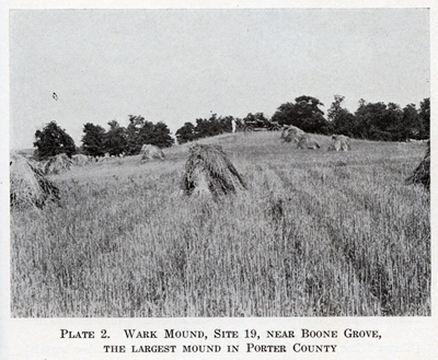
The Wark Mounds represent a group of at least ten Native American mounds located
in Sections 27, 28, 33, and 34 of Township 34 North, Range 6 West in Porter
Township, east of Boone Grove. This complex of mounds is named after one of the
former owners of land upon which several mounds are located, John Wark. The
largest mound in the group is referred to as the Wark Mound. These mounds were
known to exist as early as 1834 since they are clearly notated in the Record of
Field Notes, United States Land Survey; the notes regarding the survey of
the north-south line between Sections 33 and 34 state that "a large
artificial mound surrounded by a number of smaller ones." By 1932, many of
the mounds, especially those located in Section 33, were barely visible due to
previous excavations. Note that not every mound in this group has yielded
skeletal remains when excavated. Thus, only mounds that have yielded skeletal
remains are detailed below.
A. The Wark Mound is the largest Native American burial mound in Porter
County and is located in the northeast quarter of the northeast quarter of the
northeast quarter of Section 33, Township 34 North, Range 6 West. Being slightly
more than 100 feet in diameter, the Wark Mound was approximately 16 feet in
height before excavations reduced its height to about ten feet by 1932. The
Record of Field Notes, United States Land Survey of 1834 reports that nine
smaller mounds surrounded the Wark Mound, but by 1897 these nine smaller mounds
no longer were visually perceptible. A. E. Upp was the first man to farm the
land upon which the Wark Mound is located. It has been reported that Upp stated
that the mound was much steeper and quite difficult to plow when he began
farming the land. On October 6 and 7, 1897, State Geologist W. S. Blatchley
excavated a ditch measuring three feet wide, 32 feet long, and 14 feet deep
through the center of the Wark Mound. Near the very center of the mound was
found one very badly decayed partial skeleton; a total of 14 teeth were found
and only a few bones were recovered.
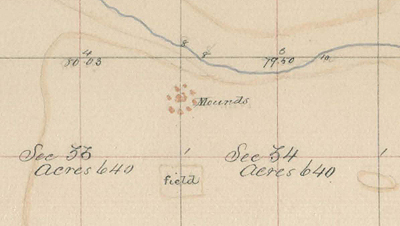
Portion of original government survey map prepared by William Clark in
1834 of Township 34
North, Range 6 West, showing the Wark Mounds
in Sections 33 and 34.
The following newspaper item concerning the Wark Mound was mentioned in the
August 23, 1916, issue of The Porter County Vidette:
"A. E. UPP FINDS PAPOOSE PLAYTHING ON FARM
A. E. Upp, residing in Boone Gove, has one of the smallest
arrowheads in existence. It is only a half-inch long and may
have been a plaything for some
papoose. While pulling weeds
the other day, Mr. Upp found it near the mounds
that are
located on his farm and that of Robert Wark, which gave up
many Indian
skeletons a year ago."
B. The Allman Mound is one of the mounds in the Wark Mounds group and is located in the approximate center of the south one-half of the northeast quarter of the northwest quarter of Section 34, Township 34 North, Range 6 West. In 1931, the diameter and height of the Allman Mound was reported to be 45 feet and 4.1 feet, respectively. State Geologist W. S. Blatchley reported that in October of 1897, Charles H. Wood, Superintendent of the Valparaiso Schools, excavated the Allman Mound. Blatchley stated that Wood found "no skeletons or implements of any kind," but that "charcoal and ashes were quite common." In 1928, J. C. Allman excavated at the center of the mound to a depth of three feet. Allman unearthed several skeletal remains, reporting that most of the bones were in an excellent state of preservation.
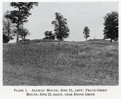
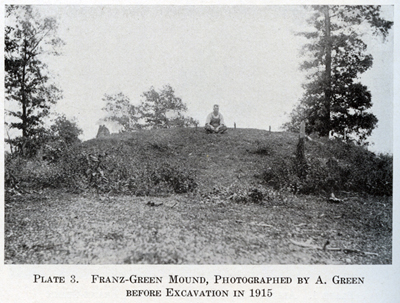
C. The Franz-Green Mound is one of the mounds in the Wark Mounds group and is located in the southeast quarter of the northeast quarter of the northwest quarter of Section 34, Township 34 North, Range 6 West. State Geologist E. W. Blatchley reported in 1897 that this mound "is 210 feet in circumference and its crest is 10 feet above the surrounding level." Blatchley reports that Charles H. Wood, Superintendent of the Valparaiso Schools, excavated at the Franz-Green Mound, but no information concerning Wood's discoveries is available. In 1915, the mound was excavated by Harvey Franz and Amos Green, from which the mound derives its name. The Franz-Green excavation resulted in the discovery of at least 17 burials, three of which were children. Numerous artifacts were also found with the burials. Interestingly, much of the soil removed from the Franz-Green Mound was taken away to be used as fill for the low areas around the barn yard of William Rampke.
D.
Two smaller mounds, known as Site 23 in McAllister's archaeological report for
Porter County published in the Indiana History Bulletin, exist on the section line between Sections 33 and 34,
Township 34 North, Range 6 West. State Geologist W. S. Blatchley reports that
one of these two mounds "is 175 feet in circumference and six feet high, the
other 75 feet in circumference and four feet in height." Blatchley and
Charles H. Wood, Superintendent of the Valparaiso Schools, excavated at Site 23 in 1897,
though results of their excavation are unknown. In the fall of 1930, J. C. Allman
and some boy scouts excavated the larger of the two mounds located at Site 23
and at a depth of four feet discovered skeletal material. The human remains were
reportedly not disturbed.
Unknown. The following newspaper item published in the The Porter
County Vidette on January 24, 1917, mentions Native American remains that
were found in the Boone Grove area. This suggests that the remains may have
possibly originated from the Wark mounds.
"Jake Marks, the west side barber,
who maintains a
collection of curios in his window,
has an addition to
it today in the form of upper and
lower jawbones
of an Indian, unearthed near Boone
Grove, and
provided for the display by Charles
Cobb."
Source Citations:
Anonymous. August 23, 1916. "A. E. Upp Finds Papoose Plaything
on Farm," The Porter County
Vidette [page 1, column 4].
Anonymous. June 1, 1956. "Indian Burial Mounds Still Dot Landscape
in Boone
Grove Area," The Vidette Messenger 29(281):8.
Anonymous. January 24, 1917. "Local Squibs and Personals,"
The Porter County Vidette
[page 3, column 1].
Bennett, Mrs. L. F. September 20, 1916. "Centennial Notes:
Geography Notes Continued," The
Porter County
Vidette [page 4, column 6].
Blatchley, W. S. 1898. "The Geology of Lake and Porter Counties,
Indiana, " in
(pp. 25-104) Indiana Department of Geology
and Natural Resources,
Twenty-second Annual Report.
Indianapolis, Indiana: William B. Buford. 1,197
p. [see pp. 86-88]
Drury, John. 1956. This is Porter County. Chicago, Illinois: Inland
Photo Company. 352 p.
Field Notes North of the Base Line and West of the 2d Meridian,
Indiana,
22:447. Located at Indiana State Archives, Indianapolis,
Indiana.
McAllister, J. Gilbert. 1932. "The Archaeology of Porter County," Indiana
History Bulletin 10(1):1-96.
The Stroller. November 10, 1960. "Bodies of 17 Warriors Found in
Battle
Regalia," The Vidette-Messenger 34(110):1, 14.
Washington Township
A. The 1882 History of Porter County, Indiana, states that (p. 178):
"A village of about one hundred or
more Pottawatomie Indians
was situated near the present site of
Prattville. Their burying-ground
was located on what is now Harmond
Beach's orchard."
An inspection of the 1876 plat map for Washington Township published by A. G.
Hardesty, shows that Harmond Beach's orchard, and thus the Native American burial ground,
is located in the northwest quarter of the northeast quarter of the southwest
quarter of Section 21, Township 35 North, Range 5 West. No evidence of the
Indian burial ground exists today.
Source Citations:
Goodspeed, Weston A., and Charles Blanchard. 1882. Counties of Lake
and
Porter, Indiana: Historical and Biographical. Chicago, Illinois:
F. A. Battey and Company. 771 p.
Hardesty, A. G. 1876. Illustrated Historical Atlas of Porter County,
Indiana.
Valparaiso, Indiana: A. G. Hardesty. 90 p.
Westchester Township
A. The Bailly Cemetery is located approximately three-quarters of a mile north of
the Joseph Bailly Homestead in Westchester Township, at the base of a sand
ridge in the center of the northeast quarter of Section 27 [click
here for detailed historical information concerning Bailly Cemetery]. It is the oldest
white burial ground in Porter County. It has been recorded that Joseph Bailly buried his son,
Napoleon B. "Robert" Bailly, here in
1827. It has also been recorded that Native Americans first used the site for
the burial of their dead. Though skeletons have been uncovered at the cemetery
site on numerous occasions, they have always been reburied without a
determination of their race. Hence, it has not been conclusively determined
whether the Bailly Cemetery was originally a sacred Indian burial ground.
B. An Native American burial ground is located just to the west of the
now nonexistent village of City West in the southwest quarter of the southeast quarter of the northeast quarter of Section 14, Township 37 North, Range 6 West. City West was laid out
along the southeasterly shore of Lake Michigan at, or just south of, the mouth
of Fort Creek. The pavilion at Indiana Dunes State Park is located just east of
where the village was located. City West competed with Michigan City for
federal funds to be used for the construction of a port, but did not gain the support of
Congress and slowly became depopulated. All the structures in City West were
destroyed by a lightening-ignited wildfire in 1854. Timothy H. Ball, a resident
of City West as a young boy, provides a firsthand account of a Native American
burial ground adjacent to City West in his book concerning the history of
Northwest Indiana in the 1800s:
"On a sand knoll, between the
village and the lake, on the bank
of the creek, there was an Indian
burial ground of some size, the
marks or inscriptions on the
head-boards seeming to have been
painted with Indian puccoon root.
Here the villagers did not bury;
this sacred spot they did not
disturb. Near this, in the summer and
fall, some Indian encampments were
held; the Indians being quiet,
peaceable hunting parties, one party
at least having come down
Lake Michigan from Green Bay, if the
information imparted to the
villagers was correct."
Hardesty's history of Porter County, published in 1876, also mentions the Native
American burial ground located near City West:
"Old City West, an Indian
barricade at the time this country was
first known to the whites, and now
used as a summer resort by many,
is the oldest point in this county
entitled to the name of a town. Mr.
Joseph C. Morgan was at an Indian
burial at this place in 1838. It
was the funeral of a squaw, wife of
the principal chief. The
ceremonies consisted of speaking,
singing, dancing and a sacred
feast of well-baked venison."
McAllister's archaeological report of Porter County mentions the Native
American burial ground near City West, stating that:
"...at a place known as
'grave-yard' blow-out, a number of
people have found skeletal material,
including vertebra with
arrow embedded in the bone."
C. McAllister's archaeological report of Porter County also reports the
existence of a Native American burial ground located in the southwest quarter of
the southeast quarter of the northeast quarter of Section 1, Township 37 North,
Range 6 West, which is approximately 500 feet southwest of the entrance to St.
Patrick Catholic Cemetery on South Calumet Road. McAllister's report states
that:
"According to W. Lahyn [William LaHayn]
and A. J. Bouser [Arthur
J. Bowser] this mound was formerly 6 feet high
and 80 feet in
diameter. It is now little more than 1.5 feet
high, though still
retaining much of its symmetry. It has been dug
into a number
of times, skeletal material and many relics
being found. The
mound has been farmed over and is now
planted in alfalfa. Only
flint chips were found at the time of
the present survey."
D. A Native American burial mound once stood between Morgan Lake and
Billington Lake on the line between Sections 5 and 6, Township 36 North, Range 5
West. Today, the mound is completely obliterated and Sand Creek Drive traverses
the site. The mound is thought to have stood about one to two hundred feet north
of the north parking lot at Sand Creek Country Club. McAllister mentions this
mound in his survey of archaeological sites in of Porter County:
"It was reported by Ed Morgan that
there were formerly three
mounds on his father's farm. He
estimates that they were
about 12 feet in diameter and
approximately 2 feet high.
They were excavated by the Morgans in
1893, but only
skeletal material was found....Two
slight elevations indicates
where they stood. The soil is a sandy
loam. Burned stone and
flint flakes were found on the
surface. Large oak trees grown
on and near the site."
E. When Wagner Road (County Road 50 West) was being constructed to
connect with the Dunes Highway (US Route 12) north of the town of Porter, seven
complete skeletons were said to have been removed, though no artifacts were
reported to be found with the skeletal remains. These Native American burials were found just west
of Wagner Road and south of the Dunes Highway, or more specifically in the
northeast quarter of the northeast quarter of the northwest quarter of Section 26,
Township 37 North, Range 6 West. The land on which the skeletal remains were
found was, at the time of discovery, owned by Benjamin and Clara Lehman.
Source Citations:
Ball, Timothy H. 1900. Northwestern Indiana From 1800 to 1900: A
View of Our Region Through the
Nineteenth Century. Chicago,
Illinois: Donohue & Henneberry. 570
p.
Bowers, John O. 1929. "Dream Cities of The Calumet," in (pp. 174-
198) History of Lake County.
Volume 10. Gary, Indiana: Lake
County Historical Association
(Calumet Press). 223 p.
Bringelson, Dawn, and Jay T. Sturdevant. 2007. An Archeological
Overview and Assessment of Indiana
Dunes National
Lakeshore, Indiana. Technical
Report No. 7. Lincoln,
Nebraska: US Department of the
Interior, National Park
Service, Midwest Archeological
Center. 160 p.
Clemenson, A. Berle, Kenneth W. Bennett, and Catherine H. Blee. 1976.
Historic Structure Report, Bailly Cemetery: Historical,
Architectural, and Archeological Data, Indiana Dunes
National Lakeshore, Indiana. United States Department of the
Interior, National Park Service,
Historic Preservation Division.
Denver, Colorado: United States
Department of the Interior. 85 p.
Hardesty, A. G. 1876. Illustrated Historical Atlas of Porter County,
Indiana. Valparaiso, Indiana: A.
G. Hardesty. 90 p.
McAllister, J. Gilbert. 1932. "The Archaeology of Porter County," Indiana
History Bulletin 10(1):1-96.
Nelson, C. W. 1949. The Bailly Cemetery. Manuscript in Reed Folder.
Porter, Indiana: Indiana Dunes
National Lakeshore Park. pp. 11-12.
Skinner, Hubert M. January 15, 1878. Complete History of Porter
County. Valparaiso, Indiana:
Published by Author.
NOTE: If you have information that you
like to add to this database, including corrections, then please contribute it
to
Steve Shook.
Native American Burial Ground data and report prepared by Steven R. Shook